
Wakefield is a village in the town of South Kingstown, Rhode Island, and the commercial center of the town. Together with the village of Peace Dale, it is treated by the U.S. Census as a component of the census-designated place identified as Wakefield-Peacedale, Rhode Island. West Kingston, another South Kingstown village, was the traditional county seat of Washington County. Since 1991, the Washington County Courthouse has been in Wakefield. The Sheriff's Office which handles corrections is also in Wakefield.

The National Register of Historic Places in the United States is a register including buildings, sites, structures, districts, and objects. The Register automatically includes all National Historic Landmarks as well as all historic areas administered by the U.S. National Park Service. Since its introduction in 1966, more than 90,000 separate listings have been added to the register.

This is a list of buildings, sites, districts, and objects listed on the National Register of Historic Places in Alabama.

This is a list of properties and districts listed on the National Register of Historic Places in Rhode Island. As of May 29, 2015, there are more than 750 listed sites in Rhode Island. All 5 of the counties in Rhode Island have listings on the National Register.

The Smithfield Road Historic District is a rural historic district in North Smithfield, Rhode Island along Old Smithfield Road. It extends along Old Smithfield Road north from its junction with Sayles Hill Road, and is roughly bisected by Spring Brook. It includes eight historic houses or farmsteads, two 19th-century cemeteries, and a dam on Spring Brook just east of the road. The district encompasses a cross-section of the development of agricultural properties in North Smithfield over the 19th century, with properties dating from 1811 to 1932. The district covers 170 acres (69 ha), which includes lands currently and formerly in agricultural use.
The Jamestown Archeological District is an expansive archaeological district which is the site of a major prehistoric Native American settlement in Jamestown, Rhode Island. The full extent of archaeologically-sensitive areas has not been fully identified, but is known to extend from Narragansett Avenue in the south to Rhode Island Route 138 in the north, and from Narragansett Bay in the west to North Road. The district overlaps the historically significant Windmill Hill Historic District, and the nearly 300-acre (120 ha) Watson Farm. The district includes one of largest Native American burying grounds in New England, and includes evidence of occupation dating to 3,000 BC.

The Furnace Hill Brook Historic and Archeological District in a historic district in Cranston, Rhode Island.
The Fisherville Historic and Archeological District is a historic site in Exeter, Rhode Island. It is centered on Fisherville Brook in northeastern Exeter, around a mill complex that flourished in the mid-19th century. It includes the foundational remnants of a gristmill, sawmill, and included an abandoned early-19th century Cape style house at the time of its National Register nomination in 1980.
The Great Salt Pond Archeological District is a historic district in New Shoreham, Rhode Island. The district was added to the National Register of Historic Places in 1990.

Hillsdale Historic and Archeological District is a historic district in Richmond, Rhode Island. The district was added to the National Register of Historic Places in 1980. It represents the site of the former textile mill village of Hillsdale.
The Potter Pond Archeological District is a large complex of archaeological sites in coastal South Kingstown, Rhode Island. The area is roughly bounded by United States Route 1, Point Judith Pond, Matunuck Beach Road, and the south coast, and includes 22 archaeologically significant sites dating from the Late Archaic through the Late Woodland periods.
The Scrabbletown Historic and Archeological District in a historic district in North Kingstown, Rhode Island.
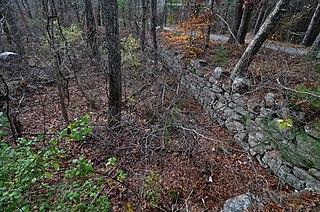
Sodom Mill Historic and Archeological District is a historic district in Exeter, Rhode Island. It includes the foundational remnants of a small early-19th century mill complex, including a dam and raceway, as well as the ruins of several 19th-century dwellings. The oldest mill on the site was built in 1814.
The Meadows Archeological District is a complex of four prehistoric archaeological sites in Warwick, Rhode Island. Discovered in 1980, the sites exhibit properties associated with the procurement and processing of stone tools. Three of the four sites include evidence of short-term habitation, and all four have shell middens. Occupation periods from the Archaic to the Woodland Period have been assigned to them. The district was added to the National Register of Historic Places in 1982, cited for its potential to yield new information about prehistoric Native patterns of living.

The Town Brook Historic and Archeological District is a historic district encompassing much of the length of Town Brook in Plymouth, Massachusetts, and its surrounding landscape. This area has an industrial history that extends to 1620, when the Pilgrims arrived on the Mayflower and established Plymouth Colony. It extends roughly from the crossing of Billington Street, to the mouth of the brook in Plymouth Harbor. The district was listed on the National Register of Historic Places in 1995.
Parris is a surname and a given name.

This is a list of the National Register of Historic Places listings in Chisago County, Minnesota. It is intended to be a complete list of the properties and districts on the National Register of Historic Places in Chisago County, Minnesota, United States. The locations of National Register properties and districts for which the latitude and longitude coordinates are included below, may be seen in an online map.

The Spot Pond Archeological District is a historic archaeological site near Spot Pond in Stoneham, Massachusetts. It is located in the Virginia Woods section of the Middlesex Fells Reservation, a state park. The district encompasses sites along Spot Pond Brook that were mill sites dating from the 17th to the 19th centuries. At its height, in the mid-19th century the Hayward Rubber Works was located in the area, giving it the name "Haywardville". One of the park's trails runs through the area, and a park pamphlet provide a self-guided tour joining the major remnants of the industries that once flourished there.


