Parting lineation

Last updated
Parting lineation, from lower left to upper right; Kayenta Formation, Canyonlands National Park PartingLineation.JPG
Parting lineation, from lower left to upper right; Kayenta Formation, Canyonlands National Park

Parting lineation (also known as current lineation or primary current lineation) is a subtle sedimentary structure in which sand grains are aligned in parallel lines or grooves on the surface of a body of sand (or lithified as a sandstone). [1] The orientation of the lineation is used as a paleocurrent indicator, although the precise flow direction (i.e. upstream vs. downstream) is often indeterminable. They are also the primary indicator of the lower part of the upper flow regime bedform.

Sand A granular material composed of finely divided rock and mineral particles, from 0.063 to 2 mm diameter

Sand is a granular material composed of finely divided rock and mineral particles. It is defined by size, being finer than gravel and coarser than silt. Sand can also refer to a textural class of soil or soil type; i.e., a soil containing more than 85 percent sand-sized particles by mass.

Sandstone A clastic sedimentary rock composed mostly of sand-sized particles

Sandstone is a clastic sedimentary rock composed mainly of sand-sized mineral particles or rock fragments.

Paleocurrent

A paleocurrent or paleocurrent indicator is a geological feature that helps one determine the direction of flowing water in the geologic past. This is an invaluable tool in the reconstruction of ancient depositional environments.

Contents

Description

Current lineation in the Inverness Formation (Pennsylvanian), Cape Breton Island, Nova Scotia Lineation mcr2.JPG
Current lineation in the Inverness Formation (Pennsylvanian), Cape Breton Island, Nova Scotia

Parting lineation is a sedimentary structure commonly found on the surface of parallel-laminated sandstones. It is aligned with the current direction, the alignment holding out in places over several square meters. [2] The lineation is formed by flat, parallel ridges which are separated by depressions or grooves. The height of the ridges rarely exceeds several grain diameters. In profile the depressions are flat-bottomed and the ridges are rounded. Ridges and depressions are arranged en echelon, so that in downstream direction the ridges pass into depressions and vice versa. The crosswise distance between individual ridges typically varies between 0.59 and 1.25 centimeters. Length as well as spacing of the ridges augments with increasing grain size: in fine-grained sands the ridges are 3.5 to 12 centimeters long, whereas in medium-grained sands they can reach 30 centimeters in length. The long dimension of the ridges is therefore 5 to 20 times their crosswise spacing. The coarse(r) sediment fraction accumulates in the ridges, whereas dark heavy minerals and mica trails take up an intermediate position between the ridges and the grooves.

Grain size diameter of individual grains of sediment, or of lithified particles in clastic rocks

Grain size is the diameter of individual grains of sediment, or the lithified particles in clastic rocks. The term may also be applied to other granular materials. This is different from the crystallite size, which refers to the size of a single crystal inside a particle or grain. A single grain can be composed of several crystals. Granular material can range from very small colloidal particles, through clay, silt, sand, gravel, and cobbles, to boulders.

In geology, a heavy mineral is one with a density that is greater than 2.9 g/cm3, most commonly referring to dense components of siliciclastic sediments. A heavy mineral suite is the relative percentages of heavy minerals in a stone. Heavy mineral suites are used to help determine the provenance and history of sedimentary rocks.

Mica phyllosilicate minerals

The mica group of sheet silicate (phyllosilicate) minerals includes several closely related materials having nearly perfect basal cleavage. All are monoclinic, with a tendency towards pseudohexagonal crystals, and are similar in chemical composition. The nearly perfect cleavage, which is the most prominent characteristic of mica, is explained by the hexagonal sheet-like arrangement of its atoms.

Fabric

Statistical studies of the spatial arrangement of the sand grains (fabric) show that in the horizontal plane the long axes of the grains form two symmetrical maxima oriented at an angle of 10 to 20 ° to the current direction. In the vertical plane these maxima are inclined at an angle of 8 to 10 ° into the current direction and the sand grains are imbricated.

Imbrication (sedimentology)

In sedimentology imbrication refers to a primary depositional fabric consisting of a preferred orientation of clasts such that they overlap one another in a consistent fashion, rather like a run of toppled dominoes. Imbrication is observed in conglomerates and some volcaniclastic deposits.

Genesis of the structure

It is meanwhile widely accepted that parting lineation forms in the turbulent, viscous boundary layer immediately above the sediment-water interface. [3] Responsible for the shaping of the structures are streaky vortex trains within the boundary layer. Downcurrent these streaks start to gradually lift off from the sediment surface until they eventually “burst”. Whenever this happens fluid rushes in from both sides. This cyclic process of lift-off, bursting and inrush of fluid exerts a shear stress on the sediment surface, which ultimately finds its expression in the spatial arrangement of the sediment grains. After all it is this lateral inrush of fluid, which “sweeps up” the grains in the grooves and redeposits them in long parallel ridges underneath the lifting turbulences. This rhythmical process is known as burst and sweep.

In physics and fluid mechanics, a boundary layer is an important concept and refers to the layer of fluid in the immediate vicinity of a bounding surface where the effects of viscosity are significant.

Vortex term in fluid dynamics

In fluid dynamics, a vortex is a region in a fluid in which the flow revolves around an axis line, which may be straight or curved. Vortices form in stirred fluids, and may be observed in smoke rings, whirlpools in the wake of a boat, and the winds surrounding a tropical cyclone, tornado or dust devil.

Streak (mineralogy) color of the powder produced when it is dragged across an un-weathered surface

The streak of a mineral is the color of the powder produced when it is dragged across an un-weathered surface. Unlike the apparent color of a mineral, which for most minerals can vary considerably, the trail of finely ground powder generally has a more consistent characteristic color, and is thus an important diagnostic tool in mineral identification. If no streak seems to be made, the mineral's streak is said to be white or colorless. Streak is particularly important as a diagnostic for opaque and colored materials. It is less useful for silicate minerals, most of which have a white streak or are too hard to powder easily.

Mode of occurrence

Modern current lineation in beach sand Lineation mcr1.JPG
Modern current lineation in beach sand

Parting lineation is restricted to coarse silts as well as to fine- and medium-grained sands (i. e. to grain sizes of 16 to 500 µ). [4] The structure very rarely occurs in coarser sediments. Hydraulically it is characteristic for the lower part of the upper plane bed regime and results from fairly high current velocities of 0.6 to 1.3 meters per second.

Silt is granular material of a size between sand and clay, whose mineral origin is quartz and feldspar. Silt may occur as a soil or as sediment mixed in suspension with water and soil in a body of water such as a river. It may also exist as soil deposited at the bottom of a water body, like mudflows from landslides. Silt has a moderate specific area with a typically non-sticky, plastic feel. Silt usually has a floury feel when dry, and a slippery feel when wet. Silt can be visually observed with a hand lens, exhibiting a sparkly appearance. It also can be felt by the tongue as granular when placed on the front teeth.

Hydraulics liquid engineering

Hydraulics is a technology and applied science using engineering, chemistry, and other sciences involving the mechanical properties and use of liquids. At a very basic level, hydraulics is the liquid counterpart of pneumatics, which concerns gases. Fluid mechanics provides the theoretical foundation for hydraulics, which focuses on the applied engineering using the properties of fluids. In its fluid power applications, hydraulics is used for the generation, control, and transmission of power by the use of pressurized liquids. Hydraulic topics range through some parts of science and most of engineering modules, and cover concepts such as pipe flow, dam design, fluidics and fluid control circuitry. The principles of hydraulics are in use naturally in the human body within the vascular system and erectile tissue. Free surface hydraulics is the branch of hydraulics dealing with free surface flow, such as occurring in rivers, canals, lakes, estuaries and seas. Its sub-field open-channel flow studies the flow in open channels.

Velocity rate of change of the position of an object as a function of time, and the direction of that change

The velocity of an object is the rate of change of its position with respect to a frame of reference, and is a function of time. Velocity is equivalent to a specification of an object's speed and direction of motion. Velocity is a fundamental concept in kinematics, the branch of classical mechanics that describes the motion of bodies.

Parting lineation forms in very different depositional environments. The structure is most commonly found on the beach where it forms in flat, wet sediments due to swash. Parting lineation can also be created in dewatering tidal channels. [5] Geological formations like for instance the Old Red Sandstone or the Buntsandstein also give proof of the shallow marine character. [6] Parting lineation has even been described from turbidites. [7] Yet the structure is not only restricted to the marine environment, it can also form in river sediments, especially on point bars.

Depositional environment The combination of physical, chemical and biological processes associated with the deposition of a particular type of sediment

In geology, depositional environment or sedimentary environment describes the combination of physical, chemical and biological processes associated with the deposition of a particular type of sediment and, therefore, the rock types that will be formed after lithification, if the sediment is preserved in the rock record. In most cases the environments associated with particular rock types or associations of rock types can be matched to existing analogues. However, the further back in geological time sediments were deposited, the more likely that direct modern analogues are not available.

Beach Area of loose particles at the edge of the sea or other body of water

A beach is a landform alongside a body of water which consists of loose particles. The particles composing a beach are typically made from rock, such as sand, gravel, shingle, pebbles. The particles can also be biological in origin, such as mollusc shells or coralline algae.

Swash A turbulent layer of water that washes up on the beach after an incoming wave has broken

Swash, or forewash in geography, is a turbulent layer of water that washes up on the beach after an incoming wave has broken. The swash action can move beach materials up and down the beach, which results in the cross-shore sediment exchange. The time-scale of swash motion varies from seconds to minutes depending on the type of beach. Greater swash generally occurs on flatter beaches. The swash motion plays the primary role in the formation of morphological features and their changes in the swash zone. The swash action also plays an important role as one of the instantaneous processes in wider coastal morphodynamics.

Parting-step lineation, [8] which is characterized by step-like parting surfaces, has been reported by Banerjee from varves deposited in glacial lakes. [9]

Parting lineation was even artificially reproduced in hydraulic experiments. [10] [11]

Remark: in the marine environment parting lineation doesn't have to be associated solely with the upper plane bed regime, it has been reported for instance from the erosive stoss side of ripple marks, megaripples and dunes. This implies that the structure can form already under lower current velocities.

Due to its varied and rather widespread occurrence parting lineation is not a unanimous indicator for depositional environments.

Theoretical considerations

In order to derive an expression for the crosswise spacing of parting lineation it is useful to start with the quadratic stress law:

τ = 1/8*f*ρ*Um2

The shear stress τ exerted by the current within the boundary layer is proportional to the square of the current velocity U. The Darcy-Weisbach friction coefficient f and the density of the fluid ρ are constants.

Empirical studies have found a dimensionless value Z = 100 for the parallel streaks/ridges. This can be equated to:

Z = 100 = ρ/η*Ut

where λ represents the measured spacing, Ut the shearing velocity and η the viscosity of the fluid.

We also have the following equality:

Ut = (τ/ρ)1/2 which yields after solving for τ:

τ = Ut2

After equating the two expressions for τ and some rearrangements one arrives at an expression for the crosswise spacing λ:

λ = 100*(η/ρ)*(8/Um2*f)1/2

By inserting the following realistic values one finds for λ:

η = 1.06*10−3 [Pa*s]

ρ = 1000 [kg/m3]

f = 0.01

Um = 1 [m/s]

λ = 100*1.06*10−6*(800)1/2 = 1.06*10−4*28.28

λ = 2.998*10−3 [m]

The calculated crosswise spacing λ is 3 millimeters. This value is in fairly close agreement with the experimental values measured by Allen, which are nevertheless generally 2 to 4 times higher. The discrepancy can be explained by assuming that only strongly developed streaks leave a discernible ridge.

Conclusions

Parting lineation is a very good indicator of the reigning current direction (and therefore also a good paleocurrent indicator). [12] An analysis of the grain fabric furthermore leads to the determination the younging direction within the sedimentary succession. The lower part of the upper plane bed hydraulic regime of relatively swift currents is characterized by parting lineation.

Related Research Articles

In fluid dynamics, turbulence or turbulent flow is fluid motion characterized by chaotic changes in pressure and flow velocity. It is in contrast to a laminar flow, which occurs when a fluid flows in parallel layers, with no disruption between those layers.

Deposition (geology) Geological process in which sediments, soil and rocks are added to a landform or land mass

Deposition is the geological process in which sediments, soil and rocks are added to a landform or land mass. Wind, ice, water, and gravity transport previously weathered surface material, which, at the loss of enough kinetic energy in the fluid, is deposited, building up layers of sediment.

Differential centrifugation

Differential centrifugation is a common procedure in biochemistry and cell biology used to separate organelles and other sub-cellular particles on the basis of sedimentation rate. Although often applied in biological analysis, differential centrifugation is a general technique also suitable for crude purification of non-living suspended particles. In a typical case where differential centrifugation is used to analyze cell-biological phenomena, a tissue sample is first lysed to break the cell membranes and release the organelles and cytosol. The lysate is then subjected to repeated centrifugations, where particles that sediment sufficiently quickly at a given centrifugation force for a given time form a compact "pellet" at the bottom of the centrifugation tube. After each centrifugation, the supernatant is removed from the tube and re-centrifuged at an increased centrifugal force and/or time. Differential centrifugation is suitable for crude separations on the basis of sedimintation rate, but more fine grained purifications may be done on the basis of density through equilibrium density-gradient centrifugation.

Turbidite The geologic deposit of a turbidity current

A turbidite is the geologic deposit of a turbidity current, which is a type of sediment gravity flow responsible for distributing vast amounts of clastic sediment into the deep ocean.

Bouma sequence

The Bouma Sequence describes a classic set of sedimentary structures in turbidite beds deposited by turbidity currents at the bottoms of lakes, oceans and rivers.

Boundary layer thickness

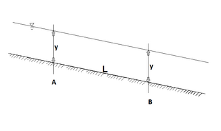
This page describes some parameters used to characterize the properties of a boundary layer formed by fluid flow along a wall. The boundary layer concept was first described by Ludwig Prandtl. Consider a stationary body with a fluid flowing around it, like the semi-infinite flat plate with air flowing over the top of the plate. At the solid walls of the body the fluid satisfies a no-slip boundary condition and has zero velocity, but as you move away from the wall, the velocity of the flow asymptotically approaches the free stream mean velocity. Therefore, it is impossible to define a sharp point at which the boundary layer becomes the free stream, yet this layer has a well-defined characteristic thickness. The parameters below provide a useful definition of this characteristic, measurable thickness. Also included in this boundary layer description are some parameters useful in describing the shape of the boundary layer.

Ekman transport Net transport of surface water perpendicular to wind direction

Ekman transport, part of Ekman motion theory first investigated in 1902 by Vagn Walfrid Ekman, refers to the wind-driven net transport of the surface layer of a fluid that, due to the Coriolis effect, occurs at 90° to the direction of the surface wind. This phenomenon was first noted by Fridtjof Nansen, who recorded that ice transport appeared to occur at an angle to the wind direction during his Arctic expedition during the 1890s. The direction of transport is dependent on the hemisphere: in the northern hemisphere, transport occurs at 90° clockwise from wind direction, while in the southern hemisphere it occurs at a 90° counterclockwise.

Cross-bedding

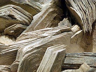
In geology, cross-bedding, also known as cross-stratification, is layering within a stratum and at an angle to the main bedding plane. The sedimentary structures which result are roughly horizontal units composed of inclined layers. The original depositional layering is tilted, such tilting not being the result of post-depositional deformation. Cross-beds or "sets" are the groups of inclined layers, which are known as cross-strata.

Ripple marks sedimentary structures

In geology, ripple marks are sedimentary structures and indicate agitation by water or wind.

Sole markings

Sole marks are sedimentary structures found on the bases of certain strata, that indicate small-scale grooves or irregularities. This usually occurs at the interface of two differing lithologies and/or grain sizes. They are commonly preserved as casts of these indents on the bottom of the overlying bed. This is similar to casts and molds in fossil preservation. Occurring as they do only at the bottom of beds, and their distinctive shapes, they can make useful way up structures and paleocurrent indicators.

Sediment transport The movement of solid particles, typically by gravity and fluid entrainment

Sediment transport is the movement of solid particles (sediment), typically due to a combination of gravity acting on the sediment, and/or the movement of the fluid in which the sediment is entrained. Sediment transport occurs in natural systems where the particles are clastic rocks, mud, or clay; the fluid is air, water, or ice; and the force of gravity acts to move the particles along the sloping surface on which they are resting. Sediment transport due to fluid motion occurs in rivers, oceans, lakes, seas, and other bodies of water due to currents and tides. Transport is also caused by glaciers as they flow, and on terrestrial surfaces under the influence of wind. Sediment transport due only to gravity can occur on sloping surfaces in general, including hillslopes, scarps, cliffs, and the continental shelf—continental slope boundary.

In fluid dynamics, the von Kármán constant, named for Theodore von Kármán, is a dimensionless constant involved in the logarithmic law describing the distribution of the longitudinal velocity in the wall-normal direction of a turbulent fluid flow near a boundary with a no-slip condition. The equation for such boundary layer flow profiles is:

Sedimentary structures include all kinds of features formed at the time of deposition. Sediments and sedimentary rocks are characterized by bedding, which occurs when layers of sediment, with different particle sizes are deposited on top of each other. These beds range from millimeters to centimeters thick and can even go to meters or multiple meters thick.

Antidune

An antidune is a bedform found in fluvial and other channeled environments. Antidunes occur in supercritical flow, meaning that the Froude number is greater than 1.0 or the flow velocity exceeds the wave velocity; this is also known as upper flow regime. In antidunes, sediment is deposited on the upstream (stoss) side and eroded from the downstream (lee) side, opposite lower flow regime bedforms. As a result, antidunes migrate in an upstream direction, counter to the current flow. Antidunes are called in-phase bedforms, meaning that the water surface elevation mimics the bed elevation; this is due to the supercritical flow regime. Antidune bedforms evolve rapidly, growing in amplitude as they migrate upstream. The resultant wave at the water's surface also increases in amplitude. When that wave becomes unstable, breaks and washes downstream, much of the antidune bedform may be destroyed.

Wave-formed ripple

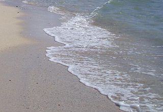
In sedimentology, wave-formed ripples or wave-formed ripple marks are a feature of sediments and dunes. These ripple marks are often characterised by symmetric cross sections and long relatively straight crests, which may commonly bifurcate. Commonly, these crests can be truncated by subsequent flows. Their wavelength (periodicity) depends on the sediment grain size, water depth and water-particle orbits in the waves. On tidal flats the pattern of wave-formed ripples may be complicated, as a product of changing depth and wind and tidal runoff directions. Symmetrical ripples are commonly found in shallow waters. Beaches are a good place to find these ripples.

Shear Velocity, also called friction velocity, is a form by which a shear stress may be re-written in units of velocity. It is useful as a method in fluid mechanics to compare true velocities, such as the velocity of a flow in a stream, to a velocity that relates shear between layers of flow.

In fluid dynamics, Airy wave theory gives a linearised description of the propagation of gravity waves on the surface of a homogeneous fluid layer. The theory assumes that the fluid layer has a uniform mean depth, and that the fluid flow is inviscid, incompressible and irrotational. This theory was first published, in correct form, by George Biddell Airy in the 19th century.

Bedform

A bedform is a feature that develops at the interface of fluid and a moveable bed, the result of bed material being moved by fluid flow. Examples include ripples and dunes on the bed of a river. Bedforms are often preserved in the rock record as a result of being present in a depositional setting. Bedforms are often characteristic to the flow parameters, and may be used to infer flow depth and velocity, and therefore the Froude number.

A dish structure is a type of sedimentary structure formed by liquefaction and fluidization of water-charged soft sediment either during or immediately following deposition. Dish structures are most commonly found in turbidites and other types of clastic deposits that result from subaqueous sediment gravity flows.

Radiation stress The depth-integrated excess momentum flux caused by the presence of the surface gravity waves, which is exerted on the mean flow

In fluid dynamics, the radiation stress is the depth-integrated – and thereafter phase-averaged – excess momentum flux caused by the presence of the surface gravity waves, which is exerted on the mean flow. The radiation stresses behave as a second-order tensor.

References

  1. Boggs, S., Principles of Sedimentology and Stratigraphy, 3rd Ed., pgs. 125-126
  2. Allen, J. R. L. (1964a). Sedimentology, 3, page 89 – 108
  3. Allen, J. R. L. (1970g). Physical Processes of Sedimentation. Allen and Unwin, London
  4. Picard, M. D. & Hulen, J. B. (1969). Geol. Soc. Am. Bull., 80, page 2631–2636
  5. Wright, P. (1976). Sedimentology, 23, page 705 – 712
  6. Brynhi, I. (1978). Norsk Geol. Tidsskr., 58, page 273 – 300
  7. Stanley, D. J. (1974). Bull. Cent. Rech. Pau, 8, page 351 – 371
  8. McBride, E. F. & Yeakel, L. S. (1963). Relationship between parting lineation and rock fabric. J. Sediment. Petrol., 33, page 779 – 782
  9. Banerjee, I. (1973). Bull. Geol. Serv. Can., n° 226, page 1 – 44
  10. Karcz, I. (1974). Fluvial Geomorphology. State University of New York, Binghamton, pp. 149 – 173. Edited by M. Morisawa
  11. Mantz, P. A. (1978). Bedforms produced by fine, cohesionless, granular and flaky sediments under subcritical water flows. Sedimentology, 25, page 83 – 103
  12. Shelton, J. W. et al. (1974). Directional features in braided-meandering stream deposits, Cimarron River, North-Central Oklahoma. J. Sediment. Petrol., 44, page 742 – 749