
The Eleazer Arnold House is a historic house built for Eleazer Arnold in about 1693, and located at 487 Great Road, Lincoln, Rhode Island in the Great Road Historic District. It is now a National Historic Landmark owned by Historic New England, and open to the public on weekends.
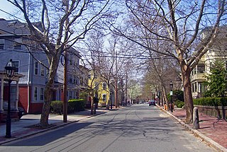
The College Hill Historic District is located on the East Side of Providence, Rhode Island, United States. It was designated a National Historic Landmark District on December 30, 1970. The College Hill local historic district, established in 1960, partially overlaps the national landmark district. Properties within the local historic district are regulated by the city's historic district zoning ordinance, and cannot be altered without approval from the Providence Historic District Commission.

The Smith Hill Historic District is a historic district located in northwestern Providence, Rhode Island, just west of the Rhode Island State House and Interstate 95. It includes 57-65 Brownell Street, 73-114 Holden Street, 23-80 Jewett Street, 189-240 Smith Street and 10-18 W. Park Street. This area is a densely built residential section, an isolated remnant of what was once a larger residential area. Most of the 41 properties are residential units built between 1870 and 1930, and are typically 2-1/2 or 3-1/2 stories in height. They are set on lot sizes ranging generally from 3000 to 5000 square feet, and are set close to the sidewalk. The only major non-residential buildings are St. Patrick's School at 244 Smith Street and "The Mohican" at 185-189 Smith Street; the latter is an Art Deco brick and concrete commercial block two stories in height.
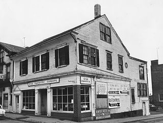
The Charles Tillinghast House was an historic house at 243-245 Thames Street in downtown Newport, Rhode Island. It was a 2 1⁄2-story timber-frame structure, with a side-gable roof. Built c. 1710–20, it was one of the oldest buildings in the city. It was probably built by Charles Tillinghast, whose family was among the founders of Rhode Island. The house had a distinctive cove-shaped plaster cornice, typically only found on houses of this period. It was one of the very first houses to be built on Thames Street.

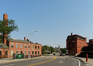
The Main Street Historic District is a historic district in the central business district of Woonsocket, Rhode Island, USA. It extends along Main Street, between the railroad tracks just northeast of its junction with Clinton Street, and roughly Ascension Street at the southwest. Most of the sixteen buildings in this area were built at the height of Woonsocket's prosperity, roughly between 1850 and 1930. The district is characterized by brick and masonry buildings generally between two and six stories in height.

The South Central Falls Historic District is a historic district in Central Falls, Rhode Island. It is a predominantly residential area, densely populated, which was developed most heavily in the late 19th century. It is bounded roughly by Broad Street to the east, the Pawtucket city line to the south, Dexter Street to the west, and Rand Street and Jenks Park to the north. It has 377 contributing buildings, most of which were built before 1920. The district was added to the National Register of Historic Places in 1991.

The Woonsocket District Courthouse is an historic court building on 24 Front Street in Woonsocket, Rhode Island.

The Candace Allen House is a historic house located at 12 Benevolent Street in the College Hill neighborhood of Providence, Rhode Island. Named after Candace Allen (1785-1872) m older sister of Zachariah Allen, a prominent Providence mill-owner.

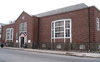
The Covell Street School is an historic school building at 231 Amherst Street in Providence, Rhode Island. It is a two-story wood frame structure built in a typically elaborate Queen Anne style. Although it is basically rectangular in plan, its roofline and exterior are busy, with a complicated group of cross gables, hip-roof sections, with projecting and recessed sections. A three-story square tower rises from the center of the main facade. Built in 1885 and opened in 1886, it is one of Providence's last surviving 19th-century neighborhood school buildings. It was designed by the local firm of William R. Walker & Son, designers of many Rhode Island civic buildings. The builders were John L. Sprague & Company.
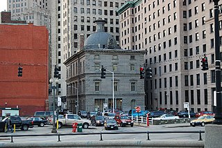
The Customhouse Historic District is a historic district encompassing fifteen historic buildings in downtown Providence, Rhode Island. The district is bounded by Westminster, Exchange, Dyer, Pine, and Peck Streets, and includes eight buildings associated with the important functions of the business center Providence became in the mid-to-late 19th century. It was listed on the National Register of Historic Places in 1975, and is completely contained within the Downtown Providence Historic District, listed in 1984.

The Thomas F. Hoppin House is a historic house at 383 Benefit Street in the College Hill neighborhood of Providence, Rhode Island. The house was built c. 1853 to a design by Alpheus C. Morse, and is an elaborate local example of an Italianate palazzo-style residence. The Hoppins were well known for the social gatherings, and their house became known as the "house of a thousand candles".
Moshassuck Square is an industrial historic district in Providence, Rhode Island, lining the banks of the Blackstone Canal just north of the Rhode Island State House. It consists of the few surviving buildings of the once-extensive American Screw Company complex, which was largely developed between the 1840s and 1870s, and was a major fixture in the Providence landscape prior to its destruction by fire in 1971. The buildings are in an area bounded by Charles Street on the west, Stevens and Hewes Streets on the north, North Main Street to the east, and Mill Street to the south. Prominent among them are the Stillman White Foundry and Fletcher Manufacturing Company office building, which stand on opposite sides of Mill Street near its crossing of the canal. At 127 Charles Street stands a three-story brick building built c. 1900 as a retail and residential building. The only surviving elements of the Screw Company complex are located at North Main and Hewes Streets, and now house the Providence Center.

The Oakland Avenue Historic District is a residential historic district in the Smith Hill neighborhood of Providence, Rhode Island, USA. The area is a densely built stretch of Oakland and Pembroke Avenues, extending from Eaton Street in the north to about half-way between Chad Brown Street and Smith Street in the south. Only buildings on the east side of Pembroke are included, while both sides of Oakland Avenue are, as are a few properties on adjacent roads. All but two of the 110 buildings in the district are residential, and are set on small lots of similar size. The houses are almost all multi-unit, housing either two or three units, and were built in between 1890 and 1930. The district represents a dense and well-preserved collection of this type of housing in the city, and was one of its last "inner city" areas to be developed.

The Providence Jewelry Manufacturing Historic District is a predominantly industrial historic district in Providence, Rhode Island. It covers a roughly 19-acre (7.7 ha) area just south of Downtown Providence, and was originally bounded by Interstate 195 prior to a realignment in the 2000s which reconnected the two areas. Although the area began as a residential area, and still has some houses in it, it developed in the late 19th and early 20th centuries as a center of Providence's jewelry manufacturing businesses. The oldest industrial building in the district is the 1848 Elm Street Machine Shop, a 2 1⁄2-story stone structure that now houses offices of Brown University.
The Smith Hill Library-Providence Community Library is one of the branch libraries of the Providence, Rhode Island, public library system. It is located at 31 Candace Street, in a single-story brick building designed by Albert Harkness and C.K. Rathbone, and built in 1932. Stylistically the building is a mixture of Colonial Revival and Moderne features. The Smith Hill branch began as a delivery station in 1907, and had grown to occupy leased space, with an annual circulation of more than 70,000, by 1929. Circulation rose rapidly after the building's completion, reaching 119,000 in just three years. The building continues to act as a significant local community resource.

The Wanskuck Historic District is a historic district in the city of Providence, Rhode Island encompassing a mill village with more than two hundred years of history. As early as the mid-18th century, mills stood on the West River in northern Providence, a development which continued with the rise of industrialization in the 19th century. The mill village of Wanskuck is organized around three thoroughfares: Branch Street, Veazie Street, and Woodward Road, and is roughly bounded on the east by Louisquisset Pike and to the northwest by the city line with North Providence. The West River runs through the district, with its banks lined by two late-19th-century mill complexes. The village area includes a variety of examples of mill worker housing, from duplexes to rowhouses, as well as two church complexes and a community hall built in 1884 by the Wanskuck Company.

The Wayland Historic District is a predominantly residential historic district on the east side of Providence, Rhode Island. It is a large area, covering about 122 acres (49 ha), bounded roughly on the north by Everett and Laurel Avenues, on the east by Blackstone Boulevard and Butler Avenue, on the west by Arlington Avenue, and on the south by Angell and South Angell Streets. This area, which was in the 19th century part of the Moses Brown farm, was platted for development in 1891, with most of the construction taking place in the early decades of the 20th century. Most of the residential properties in the district are single-family houses, typically built in revival styles popular at the time. They are set on similarly-sized lots with fairly uniform setbacks, and were typically built without garages. There are a number of two-family houses, and a small number of apartment buildings, most of which are found on the arterial roads of the area. There are several religious buildings, including several churches; the most architecturally distinctive religious building is the Jewish Temple Beth El, built 1951-54.

Westminster Street Historic District is a commercial historic district consisting of six buildings along the north side of Westminster Street in Providence, Rhode Island, a short way west of Interstate 95. Three of the buildings are located just west of Dean Street, while the other three are just to its east. Five of the six buildings were constructed between 1870 and 1900, and the sixth in 1933. These five, the most prominent of which is the Burrows Block are uniformly built of brick and masonry, while the Chiapinelli Block, at the eastern end of the district, is an Art Deco office building with a concrete main facade and brick sidewalls.

The Hope Village Historic District encompasses a historic mill village located in Scituate, Rhode Island. Located on a bend in the Pawtuxet River in southeastern Scituate, the area has seen industrial activity since the 18th century, and has surviving industrial and residential buildings from the early 19th century. The village is centered on the junction of Main Street and North Road, and radiates out from there, with numerous properties on smaller side streets. The present main mill building was built in 1844 by Brown & Ives, operators of numerous Rhode Island textile mills. Approximately 1/4 of the village's housing stock originated as mill worker housing built by the company.
The Elm Tree Plat Historic District encompasses an early 20th-century neighborhood of East Providence, Rhode Island. Developed beginning in 1924, it contains 53 single-family residences and one commercial building, most of which were built between 1925 and 1935 as a streetcar suburb development serving the Providence area. Most of the houses were built by a single pair of developers, Severin Carlson and Carl Johnson, and are one and two-story Bungalow-style houses. It is roughly bounded by Willett, Harvey, and Fenner Avenues and Charlotte Street, in southern East Providence.


