
Robeson County is a county in the southern part of the U.S. state of North Carolina and is its largest county by land area. Its county seat and largest community is Lumberton. The county was formed in 1787 from part of Bladen County and named in honor of Thomas Robeson, a colonel who had led Patriot forces in the area during the Revolutionary War. As of the 2020 census, the county's population was 116,530. It is a majority-minority county; its residents are approximately 38 percent Native American, 22 percent white, 22 percent black, and 10 percent Hispanic. It is included in the Fayetteville-Lumberton-Pinehurst, NC Combined Statistical Area. The state-recognized Lumbee Tribe of North Carolina is headquartered in Pembroke.

Pembroke is a town in Robeson County, North Carolina, United States. It is about 90 miles inland and northwest from the Atlantic Coast. The population was 2,823 at the 2020 census. The town is the seat of the state-recognized Lumbee Tribe of North Carolina, as well as the home of the University of North Carolina at Pembroke.
The University of North Carolina at Pembroke is a public university in Pembroke, North Carolina. UNC Pembroke is a master's level degree-granting university and part of the University of North Carolina system. Its history is intertwined with that of the Lumbee nation.

The Lumbee are a Native American people primarily centered in Robeson, Hoke, Cumberland, and Scotland counties in North Carolina.
Thompson Township may refer to:
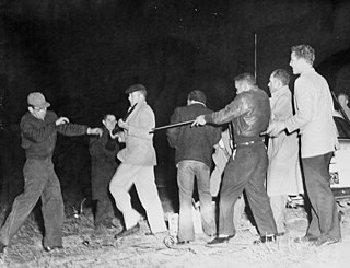
The Battle of Hayes Pond, also known as the Battle of Maxton Field or the Maxton Riot, was an armed confrontation between members of a Ku Klux Klan (KKK) organization and Lumbee people at a Klan rally near Maxton, North Carolina, on the night of January 18, 1958. The clash resulted in the disruption of the rally and a significant amount of media coverage praising the Lumbees and condemning the Klansmen.

The Lumber River, sometimes referred to as the Lumbee River, is a 133-mile-long (214 km) river in south-central North Carolina in the flat Coastal Plain. European settlers first called the river Drowning Creek, which is still used as the name of its headwater. The waterway known as the Lumber River extends downstream from the Scotland County-Hoke County border to the North Carolina-South Carolina border. Soon after crossing into South Carolina, the Lumber River flows into the Little Pee Dee River, which flows into the Pee Dee River, or Great Pee Dee River. Finally, the combined waters flow into Winyah Bay and the Atlantic Ocean.

Pembroke is a former local government area within County Dublin that was adjoining the city of Dublin, Ireland. It was formed as a township for local government purposes by a private act of Parliament in 1863. The township took its name from the fact that most of the area was part of the estate of the Earl of Pembroke. It was governed by town commissioners until 1899 when it became an urban district. In 1930 Pembroke was absorbed by the City and County Borough of Dublin.
The UNC Pembroke Braves football team represents the University of North Carolina at Pembroke in college football, competing in the Mountain East Conference. Pembroke plays its home games at the 4,000 seat Grace P. Johnson Stadium at Lumbee Guaranty Bank Field, which is located on-campus in Pembroke, North Carolina. Although only fielding a modern team since the 2007 season, Pembroke previously fielded teams between the 1946 and 1950 seasons as Pembroke State.
Smyrna Township may refer to the following places in the United States:

The Lumbee Tribe of North Carolina is a state-recognized tribe in North Carolina. The tribe represents Lumbee people. They do not hold federal recognition as a Native American tribe.
Public Schools of Robeson County is a school district headquartered in Lumberton, North Carolina. It operates public schools in Robeson County.
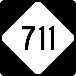
North Carolina Highway 711 (NC 711) is a primary state highway in the U.S. state of North Carolina. It connects the town of Pembroke with Interstate 95 (I-95) and U.S. Route 301 (US 301) in Lumberton. The highway travels in an east-to-west orientation but is signed as a north-south highway, entirely in Robeson County.
Ruth Dial Woods was an American educator and activist. A member of the Lumbee Tribe of North Carolina, she was the first woman to serve as the associate superintendent of the Robeson County Public Schools and to receive an at-large appointment to the University of North Carolina Board of Governors. After teaching in the public school system of Robeson County for 27 years, she joined the faculty at Fayetteville State University. In addition to her work as an educator, Woods was involved in the Civil Rights Movement, the Women's liberation movement, and the American Indian Movement. She has served as a community development consultant for the United States Department of Labor and as a consultant for the Lumbee Tribal Council for administration of tribal programs. The recipient of numerous awards and honors for her work in human rights and education, in 2011, she was inducted into the North Carolina Women's Hall of Fame.
On February 1, 1988, two armed Tuscarora men, Eddie Hatcher and Timothy Jacobs, took hostages in the offices of The Robesonian newspaper in Lumberton, Robeson County, North Carolina. At the time, Robeson experienced a significant level of drug trafficking and increasing public distrust of the county sheriff's office, especially from the area's significant Native American population. Hatcher believed he had evidence of corruption in the local justice system and, fearing for his life, enlisted the aid of Jacobs to try to raise awareness about his concerns. The two held the staff of the county daily newspaper hostage for 10 hours before extracting an agreement from North Carolina Governor James G. Martin to investigate corruption allegations in Robeson.
Moss Neck is a community in Robeson County, North Carolina, United States.
Pates is a community in Robeson County, North Carolina, United States.

Brooke Locklear Clark is a District Court Judge for Robeson County, North Carolina since she was sworn in on August 1, 2018. Clark is a Robeson County native born in Pembroke, NC.