
Midlothian is a historic county, registration county, lieutenancy area and one of 32 council areas of Scotland used for local government. Midlothian lies in the east-central Lowlands, bordering the City of Edinburgh, East Lothian and the Scottish Borders.
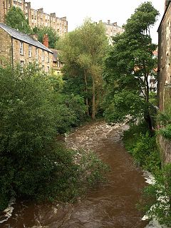
The Water of Leith is the main river flowing near central Edinburgh, Scotland, and flows into the port of Leith where it flows into the sea via the Firth of Forth.

Dalkeith is a town in Midlothian, Scotland, on the River Esk. It was granted a burgh of barony in 1401 and a burgh of regality in 1540. The settlement of Dalkeith grew southwestwards from its 12th-century castle . Dalkeith has a population of 12,342 people according to the 2011 census.
Bonnyrigg is a town in Midlothian, Scotland, eight miles southeast of Edinburgh city centre. The town had a population of 14,663 in the 2001 census which rose to 15,677 in the 2011 census, both figures based on the 2010 definition of the locality which, as well as Bonnyrigg and the adjacent settlement of Lasswade, includes Polton village, Poltonhall housing estate and modern development at Hopefield. The estimated population for 2018 is 18,120, the highest of any town in Midlothian. Along with Lasswade, Bonnyrigg is a twin town with Saint-Cyr-l'École, France.
Penicuik is a town and former burgh in Midlothian, Scotland, lying on the west bank of the River North Esk. It lies on the A701 midway between Edinburgh and Peebles, east of the Pentland Hills.
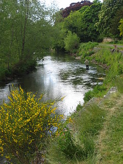
The River Esk, also called the Lothian Esk, is a river that flows through Midlothian and East Lothian, Scotland.

Loanhead is a town in Midlothian, Scotland, in a commuter belt to the south of Edinburgh, and close to Roslin, Bonnyrigg and Dalkeith. The town was built on coal and oil shale mining, and the paper industries.

Roslin is a village in Midlothian, Scotland, 11 kilometres (7 mi) to the south of the capital city Edinburgh. It stands on high ground, near the northwest bank of the river North Esk.

Lasswade is a village and civil parish in Midlothian, Scotland, on the River North Esk, nine miles south of Edinburgh city centre, contiguous with Bonnyrigg and between Dalkeith to the east and Loanhead to the west. Melville Castle lies to the north east. The Gaelic form is Leas Bhaid, meaning the "clump at the fort."

Roslin Castle is a partially ruined castle near the village of Roslin in Midlothian, Scotland. It is located around 9 miles south of Edinburgh, on the north bank of the North Esk, only a few hundred metres from the famous Rosslyn Chapel.

Bilston is a small village in Midlothian, Scotland. It is located on the edge of Edinburgh, just south of Loanhead on the A701. The Bilston Burn Site of Special Scientific Interest (SSSI) was occupied from 2002 until the mid-2010s by protestors who successfully opposed plans for a bypass.

The Edinburgh and Dalkeith Railway was an early railway built to convey coal from pits in the vicinity of Dalkeith into the capital. It was a horse-operated line, with a terminus at St Leonards on the south side of Arthur's Seat.

Larpool Viaduct, also known as the Esk Valley Viaduct is a 13 arch brick viaduct built to carry the Scarborough & Whitby Railway over the River Esk, North Yorkshire, England.
The Edinburgh, Loanhead and Roslin Railway was a railway line south of Edinburgh, Scotland, built primarily to serve mineral workings, although passenger trains were operated. It is also known as the Glencorse Branch of the North British Railway. It opened from a junction at Millerhill on the Waverley Route, to Roslin in 1874 and was extended to a location near Penicuik to serve Glencorse Barracks and a colliery in 1877 and to Penicuik Gas Works in 1878.
The Peebles Railway was a railway company that built a line connecting the town of Peebles in Peeblesshire, Scotland, with Edinburgh. It opened on 4 July 1855, and it worked its own trains.
The Esk Valley Railway was a short branch line built to serve industry in the valley of the River North Esk, south of Edinburgh in Scotland. The terminus was Polton. The line opened on 15 April 1867
The Penicuik Railway was a railway line in Midlothian, Scotland, serving paper mills located on the River North Esk. It opened in 1872 and a substantial residential passenger traffic built up. The line was 4 1/2 miles long.

The Borders Railway connects the city of Edinburgh with Galashiels and Tweedbank in the Scottish Borders. The railway follows most of the alignment of the northern part of the Waverley Route, a former double-track line in southern Scotland and northern England that ran between Edinburgh and Carlisle. That line was controversially closed in 1969, as part of the Beeching cuts, leaving the Borders region without any access to the National Rail network. Following the closure, a campaign to revive the Waverley Route emerged. Discussion on reopening the northern part of the line came to a head during the early 2000s. Following deliberations in the Scottish Parliament, the Waverley Railway (Scotland) Act 2006 received Royal Assent in June 2006. The project was renamed the "Borders Railway" in August 2008, and building works began in November 2012. Passenger service on the line began on 6 September 2015, whilst an official opening by Queen Elizabeth II took place on 9 September.


