Persan-Beaumont Airport

Last updated
Persan-Beaumont Airport
Aérodrome de Persan - Beaumont
(former Advanced Landing Ground A-60)

553d Bombardment Squadron A-26 Invader.jpg

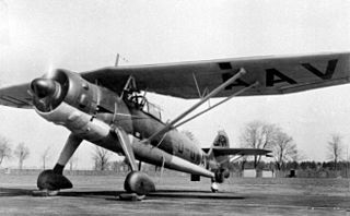
A-26C-2-DL Invader 41-39199 553rd BS, 386th BG, 9th AF Beaumont-sur-Oise Airfield (A-60), France, 2 December 1944
Summary
Airport type Public
Operator Aéroports de Paris
Serves Persan / Beaumont, France
Elevation  AMSL 149 ft / 45 m
Coordinates 49°09′54″N002°18′42″E / 49.16500°N 2.31167°E / 49.16500; 2.31167 Coordinates: 49°09′54″N002°18′42″E / 49.16500°N 2.31167°E / 49.16500; 2.31167
Map
France relief location map.jpg
Airplane silhouette.svg
LFPA
Location of Persan-Beaumont Airport
Runways
Direction Length Surface
m ft
10L/28R 830 2,723 Asphalt
10R/28L 880 2,887 Grass
05/23 975 3,199 Grass
Source: AIP France [1]

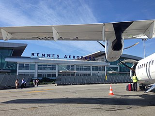
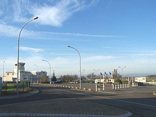
Persan-Beaumont Airport (French : Aérodrome de Persan - Beaumont, ICAO : LFPA) is a regional airport in the Val-d'Oise department in Île-de-France in northern France. It is located 3 kilometres (2 mi) northeast of Beaumont-sur-Oise, [1] 3 kilometres (2 mi) east-northeast of Persan, [2] and 32 kilometres (20 mi) north of Paris. [3] The airport supports general aviation with no commercial airline service scheduled.

French language Romance language

French is a Romance language of the Indo-European family. It descended from the Vulgar Latin of the Roman Empire, as did all Romance languages. French evolved from Gallo-Romance, the spoken Latin in Gaul, and more specifically in Northern Gaul. Its closest relatives are the other langues d'oïl—languages historically spoken in northern France and in southern Belgium, which French (Francien) has largely supplanted. French was also influenced by native Celtic languages of Northern Roman Gaul like Gallia Belgica and by the (Germanic) Frankish language of the post-Roman Frankish invaders. Today, owing to France's past overseas expansion, there are numerous French-based creole languages, most notably Haitian Creole. A French-speaking person or nation may be referred to as Francophone in both English and French.

ICAO airport code four-letter code designating many airports around the world

The ICAOairport code or location indicator is a four-letter code designating aerodromes around the world. These codes, as defined by the International Civil Aviation Organization and published in ICAO Document 7910: Location Indicators, are used by air traffic control and airline operations such as flight planning.

Val-dOise Department of France

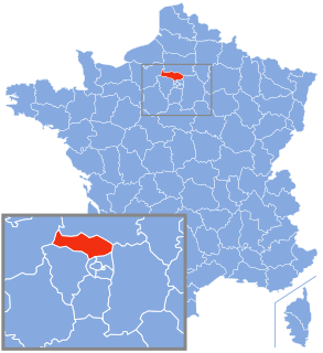
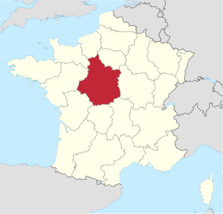
Val-d'Oise is a French department, created in 1968 after the split of the Seine-et-Oise department and located in the Île-de-France region. In local slang, it is known as "quatre-vingt quinze" or "neuf cinq", after the first two digits of the department's postcode. It gets its name from the Oise River, a major tributary of the Seine, which crosses the region after having started in Belgium and flowed through north-eastern France. Charles de Gaulle Airport, France's main international airport is partially located in Roissy-en-France, a commune of Val d'Oise.

Contents

History

Beaumont Sur Oise was a pre-World War II French Air Force airfield with a 5,000-foot (1,500 m) concrete runway (05/23).

World War II 1939–1945 global war

World War II, also known as the Second World War, was a global war that lasted from 1939 to 1945. The vast majority of the world's countries—including all the great powers—eventually formed two opposing military alliances: the Allies and the Axis. A state of total war emerged, directly involving more than 100 million people from over 30 countries. The major participants threw their entire economic, industrial, and scientific capabilities behind the war effort, blurring the distinction between civilian and military resources. World War II was the deadliest conflict in human history, marked by 50 to 85 million fatalities, most of whom were civilians in the Soviet Union and China. It included massacres, the genocide of the Holocaust, strategic bombing, premeditated death from starvation and disease, and the only use of nuclear weapons in war.

French Air Force Air warfare branch of Frances armed forces

The French Air Force[aʀme də lɛʀ], literally Army of the Air) is the air force of the French Armed Forces. It was formed in 1909 as the Service Aéronautique, a service arm of the French Army, then was made an independent military arm in 1934. The number of aircraft in service with the French Air Force varies depending on source, however sources from the French Ministry of Defence give a figure of 658 aircraft in 2014. The French Air Force has 225 combat aircraft in service, with the majority being 117 Dassault Mirage 2000 and 108 Dassault Rafale. As of early 2017, the French Air Force employs a total of 41,160 regular personnel. The reserve element of the air force consisted of 5,187 personnel of the Operational Reserve.

The airfield was seized by the Germans in June 1940 during the Battle of France. It was used by the Luftwaffe only sparingly, with Luftlandegeschwader 1 (LLG 1), a glider unit being assigned to the airfield between April and May 1943, equipped with Henschel Hs 126 liaison aircraft; Dornier Do 17s to pull the units DFS 230 transport gliders. Later, in November and December 1943, Schlachtgeschwader 4 (SLG 4) operated Focke-Wulf Fw 190F/Gs as a ground-attack unit. [4]

Battle of France Successful German invasion of France in 1940

The Battle of France, also known as the Fall of France, was the German invasion of France and the Low Countries during the Second World War. In the six weeks from 10 May 1940, German forces defeated Allied forces by mobile operations and conquered France, Belgium, Luxembourg and the Netherlands, bringing land operations on the Western Front to an end until 6 June 1944. Italy entered the war on 10 June 1940 and invaded France over the Alps.

<i>Luftwaffe</i> Aerial warfare branch of the German military forces during World War II

The Luftwaffe was the aerial warfare branch of the combined German Wehrmacht military forces during World War II. Germany's military air arms during World War I, the Luftstreitkräfte of the Army and the Marine-Fliegerabteilung of the Navy, had been disbanded in May 1920 as a result of the terms of the Treaty of Versailles which stated that Germany was forbidden to have any air force.

Henschel Hs 126 aircraft

The Henschel Hs 126 was a German two-seat reconnaissance and observation aircraft of World War II that was derived from the Henschel Hs 122. The pilot was seated in a protected cockpit under the parasol wing and the gunner in an open rear cockpit. The prototype aircraft frame was that of a Hs 122A fitted with a Junkers engine. The Hs 126 was well received for its good short takeoff and low-speed characteristics which were needed at the time. It was put into service for a few years, but was soon superseded by the general-purpose, STOL Fieseler Fi 156 Storch and the medium-range Focke-Wulf Fw 189 "flying eye".

Beaumont was attacked on several missions by the United States Army Air Forces Eighth Air Force and IX Bomber Command groups during 1943 and 1944. [5]

United States Army Air Forces aerial warfare branch of the United States army from 1941 to 1947

The United States Army Air Forces, informally known as the Air Force, or United States Army Air Force, was the aerial warfare service component of the United States Army during and immediately after World War II (1939/41–1945), successor to the previous United States Army Air Corps and the direct predecessor of the United States Air Force of today, one of the five uniformed military services. The AAF was a component of the United States Army, which in 1942 was divided functionally by executive order into three autonomous forces: the Army Ground Forces, the Services of Supply, and the Army Air Forces. Each of these forces had a commanding general who reported directly to the Army Chief of Staff.

Eighth Air Force Numbered air force of the United States Air Force responsible for strategic bomber forces

The Eighth Air Force is a numbered air force (NAF) of the United States Air Force's Air Force Global Strike Command (AFGSC). It is headquartered at Barksdale Air Force Base, Louisiana. The command serves as Air Forces Strategic – Global Strike, one of the air components of United States Strategic Command (USSTRATCOM). The Eighth Air Force includes the heart of America's heavy bomber force: the B-2 Spirit stealth bomber, the B-1 Lancer supersonic bomber, and the B-52 Stratofortress heavy bomber aircraft.

The airfield was liberated by Allied ground forces about 3 September 1944 during the Northern France Campaign. Almost immediately, the United States Army Air Forces IX Engineering Command 818th Engineer Aviation Battalion cleared the airport of mines and destroyed Luftwaffe aircraft. Fortunately, little battle damage was sustained, and the airport became a USAAF Ninth Air Force combat airfield, designated as "A-60" about 26 September. [6] [7]

Ninth Air Force Numbered air force of the United States Air Force responsible for tactical air and ground forces

The Ninth Air Force is a numbered air force of the United States Air Force's Air Combat Command (ACC). It has been headquartered at Shaw Air Force Base, South Carolina, since activation on 5 August 2009. From 1990, units were deployed to the Middle East against Iraq, and from 2001 against threats emanating from Afghanistan. This prior Ninth Air Force is now known as United States Air Forces Central (USAFCENT).

Under American control, the Ninth Air Force assigned the 386th Bombardment Group to the airport which flew B-26 Marauder medium bombers from the facility between 2 October 1944 and 9 April 1945. The 386th was replaced by the 410th Bombardment Group, an A-26 Invader group, which operated from the airport until June 1945. The Americans returned full control of the airport to French authorities on 17 July 1945. [8] [9]

Current

After the war, the airport appears to have been torn down, and a new facility constructed about 200m to the southeast. The wartime concrete runway remains in a field complete with many patches of bomb craters, connected to what appears to be the prewar French air base. At least one large hangar is still standing, and numerous support buildings. In addition, old taxiways reduced in width are being used as farm access roads.

Facilities

The airport resides at an elevation of 149 feet (45 m) above mean sea level. It has three runways: 10L/28R is paved and measures 830 by 20 metres (2,723 ft × 66 ft), 10R/28L is a parallel grass runway measuring 880 by 90 metres (2,887 ft × 295 ft), and 05/23 has a grass surface measuring 975 by 100 metres (3,199 ft × 328 ft). [1]

See also

Related Research Articles

Rennes–Saint-Jacques Airport airport

Rennes–Saint-Jacques Airport or Aéroport de Rennes–Saint-Jacques is a minor international airport about 6 kilometres (3.7 mi) southwest of Rennes, Ille-et-Vilaine, in the region of Brittany, France.

Dijon Air Base former French Air Force base in Cote-dOr, France

Dijon-Longvic Air Base was a French Air Force air base. The airfield is located approximately 2 miles (3.2 km) east-southeast of Longvic; about 165 miles (266 km) southeast of Paris. Operating as a joint civilian base, it is today used as a commercial airport named Aéroport Dijon-Bourgogne.

Amiens – Glisy Aerodrome airport in France

Amiens – Glisy Aerodrome is an airport serving Amiens, the capital city of the Somme department of the Picardy (Picardie) region in France. The airport is located 7 km (4 mi) east-southeast of Amiens, in Glisy.

Le Luc – Le Cannet Airport airport in France

Le Luc-Le Cannet Airport is an airport located at Le Cannet-des-Maures, 6 km (4 mi) east of Le Luc, in the Var department of the Provence-Alpes-Côte d'Azur region in southern France. The airport is open to public air traffic, but has no commercial airline service. It also has military use as part of Base école Général Lejay, a French Army training facility for combat helicopters and various ground equipment.

Dole–Jura Airport airport

Dole–Jura Airport, also known as Franche-Comté Regional Airport, is an airport serving Dole, a commune in the Jura department in the Bourgogne-Franche-Comté region in eastern France. The airport is located 7 km (4 NM) southwest of Dole, and southeast of Tavaux. It was formerly known as Dole–Tavaux Airport. The airport is used for general aviation, and for a few commercial airline services.

Gael Airfield Abandoned World War II military airfield

Gael Airfield is an abandoned World War II military airfield, which is located near the commune of Gaël in the Brittany region of northern France.

Meucon Airport airport in France

Vannes Airport is a regional airport in France. It supports general aviation with no commercial airline service scheduled.

Chartres – Champhol Aerodrome former French Air Force base

Chartres – Champhol Aerodrome is an airport serving Chartres and Champhol, in the Eure-et-Loir department in north-central France. The airport is located 2.5 km (1.3 NM) east-northeast of Chartres and it is southeast of Champhol. It supports general aviation with no commercial airline service scheduled.

Toussus-le-Noble Airport airport in France

Toussus-le-Noble Airport is a regional airport in France. It supports general aviation with no commercial airline service scheduled. French governmental aircraft are hangared and maintained at the airport. It is the most active airfield for general aviation in France with a record of 210,000 movements.

Brétigny-sur-Orge Air Base military airbase

Brétigny-sur-Orge Air Base is a French Air Force French: Armée de l'Air (ALA) base. The base is located approximately 2 miles (3.2 km) southeast of Brétigny-sur-Orge; about 17 miles (27 km) south of Paris.

Orléans – Bricy Air Base French Air Force base near Bricy, Loiret, France

Orléans – Bricy Air Base is a French Air Force (French: Armée de l'Air base. The base is located approximately 6 miles north-northwesst of Ingré near the city of Orléans; about 65 miles south-southwest of Paris.

Vitry-En-Artois Airport airport in France

Vitry-En-Artois Airport is a regional airport in France, located 1 mile (1.6 km) northeast of Vitry-en-Artois; 105 miles (169 km) north-northeast of Paris. It supports general aviation with no commercial airline service scheduled.

Melun Villaroche Aerodrome airport

Melun Villaroche Aerodrome is an aerodrome located 8.5 km (4.6 NM) north of Melun, a commune in the Seine-et-Marne department in the Île-de-France region in north-central France.

Coulommiers – Voisins Aerodrome airport in France

Coulommiers – Voisins Aerodrome is an airport serving Coulommiers in France. It is located in the Seine-et-Marne department, 5 km (2.7 NM) west-northwest of Coulommiers. It is also 34 miles (55 km) east of Paris.

Pontoise – Cormeilles Aerodrome airport in France

Pontoise Aerodrome or Pontoise – Cormeilles Aerodrome is an airport located 7 km (3.8 NM) northwest of Pontoise in Boissy l'Aillerie near Cormeilles-en-Vexin, all communes of the Val-d'Oise department in the Île-de-France region in northern France. The airport is also located 16 miles (26 km) northwest of Paris.

Cambrai-Niergnies Airport airport

Cambrai-Niergnies Airport is a regional airport in France, located 3 miles (4.8 km) south-southeast of Cambrai; 100 miles (160 km) north-northeast of Paris

Goetsenhoven Airfield airport in Tienen, Belgium

Goetsenhoven Military Airfield is a Belgian Air Component base, located 2 miles (3.2 km) south of Tienen, approximately 26 miles (42 km) east-southeast of Brussels (Bruxelles).

Valence-Chabeuil Airport airport in France

Valence - Chabeuil Airport is an airport in France, located about 5 miles (8 km) east of Valence and approximately 300 miles (483 km) south-southeast of Paris.

Haguenau Airport airport in France

Haguenau Airport is an airport in France, located about 2 miles southeast of Haguenau ; 15 miles north of Strasburg and 250 miles east of Paris.

Saint-André-de-lEure Airport airport in France

Saint-André-de-l'Eure Airport is a regional airport in France, located about 10 miles southwest of Évreux (Normandy).

References

  1. 1 2 3 LFPA – PERSAN BEAUMONT. AIP from French Service d'information aéronautique , effective 26 April 2018.
  2. "Distance and heading from Persan (49°09'15"N 02°16'19"E) to LFPA (49°09'54"N 02°18'42"E)". Great Circle Mapper. 21 December 2012.
  3. "Distance and heading from Paris (48°51'24"N 02°21'03"E) to LFPA (49°09'54"N 02°18'42"E)". Great Circle Mapper. 21 December 2012.
  4. The Luftwaffe, 1933-45
  5. USAFHRA Document 00220537
  6. Johnson, David C. (1988), U.S. Army Air Forces Continental Airfields (ETO), D-Day to V-E Day; Research Division, USAF Historical Research Center, Maxwell AFB, Alabama.
  7. IX Engineer Command ETO Airfields, Airfield Layout
  8. Maurer, Maurer. Air Force Combat Units of World War II. Maxwell AFB, Alabama: Office of Air Force History, 1983. ISBN   0-89201-092-4.
  9. PD-icon.svg This article incorporates  public domain material from the Air Force Historical Research Agency website http://www.afhra.af.mil/ .