Pigeon Spire

Last updated
Pigeon Spire, The Bugaboos
2015-06-21 Bugaboos 8835.jpg
Pigeon Spire
Highest point
Elevation 3,156 m (10,354 ft)
Prominence 181 m (594 ft)
Coordinates 50°43′8″N116°47′5″W / 50.71889°N 116.78472°W / 50.71889; -116.78472
Geography
Location British Columbia, Canada
District Kootenay Land District
Parent range Purcell Mountains, Columbia Mountains
Topo map NTS 82K10 Howser Creek
Geology
Mountain type Granite
Climbing
First ascent 1930 Peter Kaufmann, Oliver Eaton Cromwell
Easiest route West ridge (II, 5.4)
Pigeon Spire from the Kain Route Pigeon Spire.jpeg
Pigeon Spire from the Kain Route

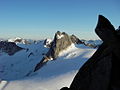
Pigeon Spire is a peak in the Purcell Mountains of the Columbia Mountains in southeastern British Columbia, Canada. It may be one of the most climbed of the spires in The Bugaboos owing to its relatively low prominence from the Vowell Glacier and the existence of an easy route (the West Ridge; II, 5.4). It is not uncommon to have a couple dozen people on this route on a busy weekend. There are longer, harder routes on the spire's North and East faces.

Routes


Related Research Articles

<span class="mw-page-title-main">Fred Beckey</span> American rock climber and mountaineer

Friedrich Wolfgang Beckey, known as Fred Beckey, was an American rock climber, mountaineer and book author, who in seven decades of climbing achieved hundreds of first ascents of some of the tallest peaks and most important routes throughout Alaska, the Canadian Rockies and the Pacific Northwest. Among the Fifty Classic Climbs of North America, seven were established by Beckey, often climbing with some of the best known climbers of each generation.

<span class="mw-page-title-main">Mount Athabasca</span> Mountain in Jasper National Park, Alberta, Canada

Mount Athabasca is in the Columbia Icefield of Jasper National Park in Canada. The mountain was named in 1898 by J. Norman Collie, who made the first ascent on August 18 of that year. Athabasca is the Cree language name for "where there are reeds", which originally referred to Lake Athabasca. Mount Athabasca is unusual, in that water flows to the Pacific Ocean from the western slope, the Arctic Ocean from the northeastern slope, and to Hudson Bay from the southeastern slope.

Pigeon is a common name for birds of the taxonomic family Columbidae, particularly the rock pigeon.

<span class="mw-page-title-main">Trango Towers</span> Granite spires in mountains in Pakistan

The Trango Towers are a family of rock towers situated in the Gilgit-Baltistan region, in the northern part of Pakistan. The Towers have some of the world's largest cliffs and offer some of the most challenging big wall climbing opportunities. Each year, climbers from around the world embark on expeditions to the Karakoram region to climb these granite faces. The Trango Towers are situated to the north of the Baltoro Glacier and are part of the Baltoro Muztagh, which is a sub-range within the Karakoram mountain range. The highest point within the group is the summit of Great Trango Tower at 6,286 m (20,623 ft), the east face of which features the world's greatest nearly vertical drop.

<span class="mw-page-title-main">Foothills Parkway</span> National parkway in Tennessee

The Foothills Parkway is a national parkway which traverses the foothills of the northern Great Smoky Mountains in East Tennessee, located in the southeastern United States. The 72.1-mile (114 km) parkway will connect U.S. Route 129 along the Little Tennessee River in the west with Interstate 40 (I-40) along the Pigeon River in the east.

<span class="mw-page-title-main">The Bugaboos</span>

The Bugaboos are a mountain range in the Purcell Mountains of eastern British Columbia, Canada. The granite spires of the group are a popular mountaineering destination. The Bugaboos are protected within Bugaboo Provincial Park.

<span class="mw-page-title-main">Wetterhorn Peak</span> Mountain in Colorado, United States

Wetterhorn Peak is a fourteen thousand-foot mountain peak in the U.S. state of Colorado. It is located in the Uncompahgre Wilderness of the northern San Juan Mountains, in northwestern Hinsdale County and southeastern Ouray County, approximately 9 miles (14 km) east of the town of Ouray and 2.75 mi (4.4 km) west of Uncompahgre Peak.

<span class="mw-page-title-main">Slesse Mountain</span>

Slesse Mountain, usually referred to as Mount Slesse, is a mountain just north of the US-Canada border, in the Cascade Mountains of British Columbia, near the town of Chilliwack. It is notable for its large, steep local relief. For example, its west face drops over 1,950 m (6,398 ft) to Slesse Creek in less than 3 km (2 mi). It is also famous for its huge Northeast Buttress; see the climbing notes below. The name means "fang" in the Halkomelem language. Notable nearby mountains include Mount Rexford and Canadian Border Peak in British Columbia, and American Border Peak, Mount Shuksan, and Mount Baker, all in the US state of Washington.

<span class="mw-page-title-main">Snowpatch Spire</span> Mountain in British Columbia, Canada

Snowpatch Spire is a mountain peak in British Columbia, Canada. With its first ascent in 1940, it was the last of the Bugaboo Spires to be climbed. It is located southwest of the Conrad Kain hut, between Bugaboo, Vowell and Crescent Glaciers, at the south end of Bugaboo Provincial Park. The mountain's toponym was officially adopted October 29, 1962, by the Geographical Names Board of Canada.

<span class="mw-page-title-main">Bugaboo Spire</span> Mountain peak in the country of Canada

Bugaboo Spire is a peak in Bugaboo mountain range in Canada, located between the Vowell and Crescent glaciers, just under 2 km West of the ACC's Conrad Kain hut. It is known for its alpine climbing. The Spire was first climbed by Conrad Kain in 1916.

<span class="mw-page-title-main">Devils Thumb</span> Mountain in the Stikine Icecap region

Devils Thumb, or Taalkhunaxhkʼu Shaa in Tlingit, is a mountain in the Stikine Icecap region of the Alaska–British Columbia border, near Petersburg. It is named for its projected thumb-like appearance. Its name in the Tlingit language means "the mountain that never flooded" and is said to have been a refuge for people during Aangalakhu. It is one of the peaks that marks the border between the United States and Canada, and is also listed on maps as Boundary Peak 71.

<span class="mw-page-title-main">Silver Star Mountain (Okanogan County, Washington)</span> Mountain in Washington, United States

Silver Star Mountain is an 8,876-foot (2,705-metre) mountain located in Okanogan County, Washington. The mountain is part of the Methow Mountains, a subset of the Cascade Range. Silver Star is the dominant feature in the Washington Pass area and visible from the North Cascades Highway. It was first climbed by Lage Wernstedt in 1926.

<i>Fifty Classic Climbs of North America</i> 1979 non-fiction book

Fifty Classic Climbs of North America is a climbing guidebook and history written by Steve Roper and Allen Steck. It is considered a classic piece of climbing literature, known to many climbers as simply "The Book", and has served as an inspiration for more recent climbing books, such as Mark Kroese's Fifty Favorite Climbs. Though much of the book's contents are now out of date, it is still recognized as a definitive text which goes beyond the traditional guidebook.

<span class="mw-page-title-main">Howser Spire</span> Mountain in British Columbia, Canada

Howser Spire, or Howser Spire Massif, is a group of three distinct granite peaks, and the highest mountain of the Canadian Bugaboo Spires. The mountain is located at the southwest corner of the Vowell Glacier, within the Bugaboo mountain range in the Purcell Mountains, a subrange of British Columbia's Columbia Mountains, The highest of the three spires is the North Tower at 3,412 m (11,194 ft), the Central Tower the lowest, and the South Tower is slightly lower than the North at 3,292 m (10,801 ft).

<span class="mw-page-title-main">Crescent Spire</span> Mountain in the country of Canada

Crescent Spire is a peak in the Purcell Mountains of the Columbia Mountains in southeastern British Columbia, Canada. Crescent Spire was named in 1933 by James Monroe Thorington because he was impressed with its shape.

<span class="mw-page-title-main">Brenta Spire</span>

Brenta Spire is a peak in the Purcell Mountains of the Columbia Mountains in southeastern British Columbia, Canada. Brenta Spire is the highest and middle of the three granite spires on a cirque west of Cobalt Lake.

<span class="mw-page-title-main">Mount Rexford</span> Mountain in British Columbia, Canada

Mount Rexford is a prominent 2,329-metre (7,641-foot) mountain summit located in the Cascade Mountains of southwestern British Columbia, Canada. It is situated 3.5 km (2 mi) north of the Canada–United States border, 7 km (4 mi) west of Chilliwack Lake, and 5.5 km (3 mi) east of Slesse Mountain, which is its nearest higher neighbor. Precipitation runoff from the peak drains into Nesakwatch and Centre Creeks, both tributaries of the Chilliwack River. Originally known as Ensawkwatch, the mountain was named for an early settler in the area, Rexford, who had a cabin near Slesse Creek and had trap lines in the vicinity. The mountain has two subsidiary peaks known as the Nesakwatch Spires. The mountain's name was officially adopted on June 2, 1950, by the Geographical Names Board of Canada. Mount Rexford was first climbed in July 1951 by Herman Genschorek and Walt Sparling via the West Ridge.

<span class="mw-page-title-main">Needle Peak (British Columbia)</span> Mountain in British Columbia, Canada

Needle Peak is a prominent 2,095-metre (6,873-foot) mountain summit located in the Coquihalla Summit Recreation Area, in the North Cascades of southwestern British Columbia, Canada. It is situated immediately southwest of Coquihalla Summit, and 4.2 km (3 mi) south-southwest of Yak Peak. Due to its close proximity to the Coquihalla Highway, the mountain is a popular hiking destination in summer, and skiing and snowshoeing in winter. Precipitation runoff from the peak drains into tributaries of the Coquihalla River. The mountain's descriptive name was officially adopted on October 6, 1936, by the Geographical Names Board of Canada.

<span class="mw-page-title-main">Lucifer Peak</span>

Lucifer Peak is a 2,726-metre (8,944-foot) mountain summit located in the Valhalla Ranges of the Selkirk Mountains in southeast British Columbia, Canada. It is situated in western Valhalla Provincial Park, 8.8 km (5.5 mi) west-northwest of Gladsheim Peak, 18 km (11 mi) west of Slocan Lake, and 20 km (12 mi) west-northwest of Slocan. This peak's name was officially adopted July 26, 1977, by the Geographical Names Board of Canada. The peak is located in Devils Range, which is a subrange of the Valhallas. The names of the peaks of this small compact range have a devil-related theme: Black Prince Mountain, Mount Mephistopheles, Devils Dome, Mount Diablo, Satan Peak, Devils Spire, and Devils Couch. Based on the Köppen climate classification, Lucifer Peak has a subarctic climate with cold, snowy winters, and mild summers. Temperatures can drop below −20 °C with wind chill factors below −30 °C. Precipitation runoff from the mountain drains into Gwillim Creek and Evans Creek, both tributaries of the Slocan River. The first ascent of the peak was made August 24, 1970, by Bob Dean and Howie Ridge via the east ridge.

<span class="mw-page-title-main">Devils Dome</span>

Devils Dome is a 2,769-metre (9,085-foot) mountain summit located in the Valhalla Ranges of the Selkirk Mountains in southeast British Columbia, Canada. It is situated in western Valhalla Provincial Park, 1.5 km (0.93 mi) east of Lucifer Peak, 5 km (3.1 mi) west of Devils Couch, and 18 km (11 mi) west of Slocan and Slocan Lake. The peak is located in Devils Range, which is a subrange of the Valhallas. Devils Dome has a subpeak, unofficially called Dark Prince, 100 m (328 ft) to the west. The names of the peaks of this small compact range have a devil-related theme: Black Prince Mountain, Lucifer Peak, Mount Mephistopheles, Mount Diablo, Satan Peak, Devils Spire, and Devils Couch. This peak's name was submitted by Pat Ridge of the Kootenay Mountaineering Club and officially adopted July 27, 1977, by the Geographical Names Board of Canada. The first ascent of the peak was made in 1973 by Howie Ridge, Peter Wood, and G. Stein via the southeast ridge.