Pilgrims' Cross, Holcombe Moor

Last updated

Pilgrims' Cross, Holcombe Moor
The Pilgrims Cross - geograph.org.uk - 4006977.jpg
Pilgrims' Cross, Holcombe Moor
53°39′35″N2°20′49″W / 53.6598°N 2.3469°W / 53.6598; -2.3469
Location Holcombe Moor near Ramsbottom
Beginning date12th century as a wayside cross
Restored dateReplaced in 1902 with an inscribed stone

Pilgrims' Cross, Holcombe Moor, also called Whowell's Cross and Chatterton's Cross, is located on Holcombe Moor near Ramsbottom and Holcombe, Greater Manchester, England. It marks the site of a 12th-century stone wayside cross, originally placed for the use of travellers, for prayer and as a guide post.

Contents

Description

Known locally as the Pilgrims' Cross, [1] the current monument dates from 1902, marking the site of an ancient cross that is recorded as standing in 1176, and possibly earlier. [2] It is located on Holcombe Moor above Bury, [2] not far from the Peel Monument and on the edge of a Ministry of Defence Danger Area. [3] It is "on the western side of the Irwell valley [where the land] rises to a height of over 1,200 feet (370 metres) above the sea. Anciently [the moor] formed part of the forest or chase of Tottington, belonging to the Earl of Lancaster and afterwards to the Lacies, earls of Lincoln". [4] Monuments on high moorland such as Pilgrims' Cross served as guide posts for travellers, to tell them how far they had travelled and to aid orientation in bad weather. [2]

History

Whitaker (1801) says that the existence of the Pilgrims' Cross, as mentioned in 1225, indicated the route of pilgrims travelling from the north of England to Walsingham and Canterbury. Land in Holcombe Forest was left in that year to Bretton Priory, including "three acres of meadow near Pilgrims' Cross Shaw ... a resting place of the pilgrims". He also mentions the Plantaganets and Lacys, who travelled via the monument's location to Lancaster, from their castles in Clitheroe and Pontefract. "What trains of sumpter horses must upon these occasions have been seen traversing these boggy wastes, impassable at that time for carriages. This was the line the Lacys were condemned to pursue". [5]

Before destruction, the ancient cross was called variously Whowell's Cross and Chatterton's Cross. [2] The Lancashire Evening Post suggested that, "The cross itself was believed to have been broken by drunken quarrymen generations before [the base stone was destroyed]". [6] What little is known of the history of the Pilgrims' Cross is inscribed on the stone monument itself which was erected on 24 May 1902 after the original socket was destroyed "by vandals" in 1901. [2] [7] A letter from the Reverend Henry Dowsett to the Manchester Evening News was published on 24 August of the same year: [nb 1] [8]

The Rector of Holcombe ... writes that the massive foundation, all that remained of the ancient Pilgrims' cross stone on Holcombe Hill, has recently been destroyed. The stone was seen alright three weeks ago, but now it has been broken up.. The cross was close to the ancient moorland footpath, and is mentioned as far back as 1225. It was probably in position on Holcombe Hill at a much earlier date. [8]

The original foundation stone of the Pilgrim's Cross Original Pilgrims Cross foundation stone (2).jpg
The original foundation stone of the Pilgrim's Cross

On 7 September 1901, Dowsett provided the Manchester City News with further information about the foundation stone. [5]

The stone was a block of sandstone, weighing perhaps a ton, and showing the cavity squared for the shaft almost as well cut as when it left the mason's hands 700 years ago. There was only just a little weathering of the angles. A simple block of sandstone ... now it lies in fragments ... scattered here and there ... The stone was not a quarried one. It belonged to that class found upon our hillsides here, among glacial drift and moraine matter. It was of rather a finer grain than the stone now being quarried on our moor ... Our Pilgrims' Cross stone had been dressed and squared by the mason's hand, though a little roughly so here and there. [5]

On 30 August 1901, the Heywood Advertiser added more about the destruction, saying that the Pilgrims' Cross foundation stone had been "broken into fragments and pieces thrown into a boghole and covered with whinberry roots". [9] By 1903 the identity of the vandals was still unknown. [10] The Manchester City News said: [11]

Its demolition is an act of pure vandalism, for which one can find no excuse, and for which it is difficult even to suggest a motive. It appears to have been carried out by clumsy depredators. Wedges had been inserted in the block.The wedge holes were badly made, and other marks show the unskilful use of heavy hammers. The destruction was evidently committed on the site, and the broken fragments were afterwards carried to the wet boghole, twenty yards distant, in which they were found. Unfortunately they are too numerous, there being at least fifty, for any hope to be entertained of the stone being pieced together again and replaced in its old site. [11]

Inscription

Pilgrim's Cross, in 1910 Pilgrims Cross Holcombe Moor in 1910.JPG
Pilgrim's Cross, in 1910
The memorial monument being carried through Holcombe on 24 May 1902 Pilgrims Cross Memorial stone being carried through Holcombe village 1902 (2).jpg
The memorial monument being carried through Holcombe on 24 May 1902

On this site stood the ancient Pilgrims Cross. It was standing in A.D. 1176 and probably much earlier. Pilgrims to Whalley Abbey prayed and rested here.

In A.D. 1176 and in A.D. 1225 the Pilgrims Cross is named in charters of gifts of land in Holcombe forest. In A.D. 1662 King Charles II gave this manor to General Monk, Duke of Abermarle through whom it has descended to the present lord of the manor.

Nothing is known of the removal of the ancient cross, but its massive socketed foundation remained here until August 1901.

This memorial stone was placed here May 24th 1902 by the copyholders of the manor and others. [2]

A local newspaper reported that "The stone [is] of huge proportions, and required the strength of fourteen horses to drag it up the hill" on Empire Day, Saturday 24 May 1902. [12] The cart was pulled from Fletcher Bank Quarry at the other side of the Irwell Valley, [6] [13] "with much laborious effort". [14] The monument is constructed of two Millstone Grit blocks, weighing in total roughly 6 long tons (6.1 tonnes). [15] Henry Dowsett was "instrumental in the erection of the monument now on the site", [16] and headed the fundraising committee. [17] On 28 June 1902, [7] [18] Dowsett presided over the erection ceremony, which was attended by hundreds, including "prominent local gentlemen". [18] [15] The stone was funded by subscription. [18] The inscription states that "Pilgrims to Whalley Abbey prayed and rested here", but Whalley Abbey was not founded until the late 13th century when the monks relocated from nearby Stanlow Abbey in April 1296. [19] In fact, Rev. Henry Dowsett, who ordered the inscription on the stone, confirmed the cross pre-dated the abbey, minutes after dedicating the memorial monument in 1902. He said that: [20]

The ancient cross was in existence long before Whalley Abbey was built. It would have been in existence probably 150 to two hundred years previously, at a time when Holcombe Moor was a forest and when people could hear the bark of the wolf and the scream of the falcon. Its purpose was to guide pilgrims to Whalley, and it had indicated the way to thousands of them. [20]

Later history

Pilgrims' Cross with firing range warning signs, 2007 Pilgrim's Cross on Holcombe Moor - geograph.org.uk - 534186.jpg
Pilgrims' Cross with firing range warning signs, 2007
Pilgrims' Cross Fell Race 2013 Pilgrim's Cross Fell Race 2013 (1) 24.jpg
Pilgrims' Cross Fell Race 2013

In 1909 and 1910, the moorland which included the Pilgrims' Cross was at risk of enclosure, when the Territorial Army attempted to requisition it for a rifle range, and possibly "artillery work", in anticipation of imminent war in Europe. Local walkers and farmers were united in their objections to the scheme. [21] [22] [23] The shooting range at Hawkshaw was initiated in 1916. [24] By 1948, the land around the cross was being "used by the army", [25] and in 1987 the army and hikers were still jostling for use of the land. [24] As of 2024 there was still a firing range on Holcombe Moor. [26]

On 6 February 1914, the body of cotton worker Reginald Geldard of Holcombe, aged around 36, was found lying in a pool of water 200 yards (180 m) from the Pilgrims' Cross, with a bullet wound in his head and a pistol in his hand. It was speculated that he may have been intimidated by the idea of a hospital operation. [27]

In 1935 the monument collapsed, "apparently because of the mortar in the foundations perishing". The monument was restored by public subscription. [6] In more recent times, the monument has been used as a landmark for hikers. For example, in 1991, a 7-mile (11 km) dog-walk for charity was organised between Holcombe Brook and the Pilgrims' Cross. [28] In 1975 a group of Girl Guides used the landmark as an expeditionary focus for map-reading and the use of a compass. [29] Local residents were put out when Ordnance Survey (OS) omitted the Pilgrims' Cross from its new Pathfinder map in 1992. However, the OS admitted its mistake and promised to "put it back in future publications". [30] Pilgrims' Cross Fell Race is held annually. [31] In 1993 there was a Pilgrims' Cross Fell Race for sixty competitors on a figure-of-eight route via Helmshore, Holcombe Moor and the monument. [32]

Notes

  1. Author Henry Dowsett (1839 –10 January 1917), ordained at Peterborough Cathedral, rector of Emmanuel Church, Holcombe 1872–1905. His books on Holcombe were Notes on Holcombe (1901) and Holcombe Long Ago (1902). He is memorialised inside the church, and buried in the churchyard.

Bibliography

Related Research Articles

<span class="mw-page-title-main">Bury, Greater Manchester</span> Market town in Greater Manchester, England

Bury is a market town on the River Irwell in the Metropolitan Borough of Bury, Greater Manchester, England. which had a population of 81,101 in 2021 while the wider borough had a population of 193,846.

<span class="mw-page-title-main">Rochdale</span> Town in Greater Manchester, England

Rochdale is a town in Greater Manchester, England, and the administrative centre of the Metropolitan Borough of Rochdale. In the 2021 census the town had a population of 111,261, compared to 223,773 for the wider borough. Rochdale is in the foothills of the South Pennines and lies in the dale (valley) of the River Roch, 5 miles (8 km) northwest of Oldham, and 10 miles (16 km) northeast of Manchester.

<span class="mw-page-title-main">Whalley, Lancashire</span> Human settlement in England

Whalley is a large village and civil parish in the Ribble Valley on the banks of the River Calder in Lancashire, England. It is overlooked by Whalley Nab, a large wooded hill over the river from the village. The population of the civil parish was 2,645 at the census of 2001, and increased to 3,629 at the census of 2011.

<span class="mw-page-title-main">Haslingden</span> Town in Rossendale, Lancashire, England

Haslingden is a town in Rossendale, Lancashire, England. It is 16 miles (26 km) north of Manchester. The name means 'valley of the hazels' or 'valley growing with hazels'. At the time of the 2011 census the town had a population of 15,969. The town is surrounded by high moorland; 370 m (1215 ft) to the north; 396 m (1300 ft) Cribden to the east; 418 m (1372 ft) Bull Hill to the south.

<span class="mw-page-title-main">Heywood, Greater Manchester</span> Human settlement in England

Heywood is a town in the Metropolitan Borough of Rochdale, Greater Manchester, England, in the historic county of Lancashire. It had a population of 28,205 at the 2011 Census. The town lies on the south bank of the River Roch, 2 miles (3.2 km) east of Bury, 4 miles (6.4 km) southwest of Rochdale, and 8 miles (12.9 km) north of Manchester. Middleton lies to the south, whilst to the north is the Cheesden Valley, open moorland, and the Pennines. Heywood's nickname is Monkey Town.

<span class="mw-page-title-main">Ramsbottom</span> Town in Greater Manchester, England

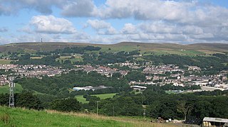
Ramsbottom is a market town in the Metropolitan Borough of Bury, Greater Manchester, England. The population at the 2011 census was 17,872.

<span class="mw-page-title-main">Whalley Range, Manchester</span> Suburb of Manchester, England

Whalley Range is an area of Manchester, England; it is located about 2 miles (3.2 km) south-west of the city centre. The population at the 2011 census was 15,430. Historically in Lancashire, it was one of the earliest of the city's suburbs, built by local businessman Samuel Brooks.

<span class="mw-page-title-main">Peel Monument, Ramsbottom</span> Commemorative monument

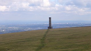
The Peel Monument at Ramsbottom, Lancashire, England, is one of two monuments in the area erected in memory of Prime Minister and founder of the police force Robert Peel, who was born in Bury. It is on Harcles Hill near Ramsbottom, 1100 feet above sea level. Because of its proximity to the village of Holcombe, Harcles Hill is more commonly known as Holcombe Hill and the monument as Holcombe or Peel Tower.

<span class="mw-page-title-main">Holcombe, Greater Manchester</span> Human settlement in England

Holcombe is a village in Ramsbottom ward, Metropolitan Borough of Bury, in Greater Manchester, England. It is situated south of Haslingden, east of Edgworth, west of Ramsbottom, and north of Tottington. The name comes from the Celtic cwm meaning valley, and the Old English hol, meaning deep or hollow.

<span class="mw-page-title-main">Affetside</span> Village in the Metropolitan Borough of Bury, in Greater Manchester, England

Affetside is a village in Greater Manchester, England. Historically in Lancashire, it is in the Tottington ward of Bury Metropolitan Borough Council and the Bury North parliamentary constituency, in the West Pennine Moors.

<span class="mw-page-title-main">Snake Pass</span> Hill pass in the Derbyshire section of the Peak District

Snake Pass is a hill pass in the Derbyshire section of the Peak District, crossing the Pennines between Glossop and the Ladybower Reservoir at Ashopton. The road was engineered by Thomas Telford and opened in 1821. The pass carries the A57 road between Manchester and Sheffield, but it is no longer the main signposted route between those two cities, with traffic instead directed through the Woodhead Pass to the north.

<span class="mw-page-title-main">Helmshore</span> Human settlement in England

Helmshore is a village in the Rossendale Valley, Lancashire, England, south of Haslingden between the A56 and the B6235, 16 miles (26 km) north of Manchester. The population at the 2011 census was 5,805. The housing in Helmshore is mixed, with some two-up, two-down terraces, top-and-bottom houses and a few surviving back-to-back cottages. Between the 1970s and 2020 new housing estates have proliferated.

<span class="mw-page-title-main">High Sheriff of Lancashire</span> Ancient English office, now largely ceremonial

The High Sheriff of Lancashire is an ancient office, now largely ceremonial, granted to Lancashire, a county in North West England. High Shrievalties are the oldest secular titles under the Crown, in England and Wales. The High Sheriff of Lancashire is the representative of the monarch in the county, and is the "Keeper of The King's Peace" in the county, executing judgements of the High Court through an Under Sheriff.

The 1901–02 Northern Rugby Football Union season was the seventh season of rugby league football run by England's Northern Rugby Football Union. A number of off-season changes made this season different from preceding ones. In June 1901 fourteen leading clubs from both Lancashire and Yorkshire resigned from their respective County Championships to form a new Northern Rugby Football League.

<span class="mw-page-title-main">British Muslim Heritage Centre</span> Building in Manchester, England

The British Muslim Heritage Centre, formerly the GMB National College, College Road, Whalley Range, Manchester, England, is an early Gothic Revival building. The centre was designated a Grade II* listed building on 3 October 1974.

Heywood F.C. was an English association football club based in Heywood, Lancashire. The club was a founder member of the Lancashire League in 1889. In the 1891–92 season, Heywood made their first appearance in the FA Cup, reaching the Second Qualifying Round. They left the Lancashire League in 1892 after finishing bottom of the table with only one win from 22 matches. The club then folded and were re-formed 5 years later in 1897, mainly from the recently folded Heywood Rovers setup.

<span class="mw-page-title-main">Norma Whalley</span> Australian actress

Norma Whalley was an Australian theatre and film actress active in the United States and Britain.

The Lancashire Militia was an auxiliary military force in Lancashire in North West England. From their formal organisation as Trained Bands in 1558 and their service in the Williamite War in Ireland and against the Jacobite Risings, the Militia regiments of Lancashire served during times of international tension and all of Britain's major wars. They provided internal security and home defence but sometimes operated further afield, including Ireland and the Mediterranean, relieving regular troops from routine garrison duties, and acting as a source of trained officers and men for the Regular Army. All the infantry battalions went on active service during the Second Boer War and all served as Special Reserve training units in World War I, with one battalion seeing considerable action on the Western Front. After 1921 the militia had only a shadowy existence until its final abolition in 1953.

The 1st Royal Lancashire Militia (The Duke of Lancaster's Own) was an auxiliary regiment raised in the county of Lancashire in North West England during the 17th Century. Primarily intended for home defence, it saw active service in Ireland under King William III, as well as against the Jacobite Risings of 1715 and 1745. It spent long periods on defence duties during the wars of the 18th Century and early 19th Century, and was stationed on the Ionian Islands during the Crimean War. It later became part of the King's Own (Royal Lancaster Regiment) and saw active service in the Second Boer War. After its conversion to the Special Reserve under the Haldane Reforms, it supplied reinforcements to the fighting battalions during World War I. After a shadowy postwar existence the unit was finally disbanded in 1953.

<span class="mw-page-title-main">H. E. and A. Bown</span> English architect

H. E. and A. Bown was an architectural practice in Harrogate, North Riding of Yorkshire, England, in the 19th and early 20th centuries. Its two partners were Henry Edwin Bown who started the business and died at the age of 36, and his brother Arthur Bown, who carried on the business until he retired in 1911.

References

  1. "A walk through the history of Holcombe Moor" (PDF). holcombemoorheritagegroup.org. Retrieved 1 January 2024.
  2. 1 2 3 4 5 6 "Pilgrims Cross, Holcombe Moor, Bury". Lancashire Past. 5 October 2013. Retrieved 1 January 2024.
  3. "Pilgrim's Cross on Holcombe Moor". geograph.org.uk. Retrieved 1 January 2024.
  4. "Antiquarians at Holcombe Moor" . Manchester Courier. 15 May 1905. p. 7 col.6. Retrieved 3 January 2024 via British Newspaper Archive.
  5. 1 2 3 "Answers. The Pilgrim's Cross on Holcombe Moor" . Manchester City News. 14 September 1901. p. 2 col.1. Retrieved 2 January 2024 via British Newspaper Archive.
  6. 1 2 3 "Pilgrims' Cross" . Lancashire Evening Post. 26 September 1935. p. 6 col.7. Retrieved 3 January 2024 via British Newspaper Archive.
  7. 1 2 "Ramsbottom" . Lancashire Evening Post. 24 June 1902. p. 4 col.4. Retrieved 2 January 2024 via British Newspaper Archive.
  8. 1 2 "The Pilgrims' Cross at Holcombe Hill" . Manchester Evening News. 24 August 1901. p. 3 col.1. Retrieved 2 January 2024 via British Newspaper Archive.
  9. "A stupid piece of vandalism" . Heywood Advertiser. 30 August 1901. p. 4 col.4. Retrieved 3 January 2024 via British Newspaper Archive.
  10. "Bolton Walkers: the third ramble" . Bolton Evening News. 17 September 1903. p. 3 col.3. Retrieved 3 January 2024 via British Newspaper Archive.
  11. 1 2 "The Pilgrim's Cross, Holcombe: a piece of wanton vandalism" . Manchester City News. 7 September 1901. p. 2 col.1. Retrieved 3 January 2024 via British Newspaper Archive.
  12. "Local and district news" . Bolton Evening News. 28 May 1902. p. 2 col.3. Retrieved 2 January 2024 via British Newspaper Archive.
  13. "Pilgrims cross (replacement) AR-p52a.jpg". ramsbottomheritage.org.uk. Ramsbottom Heritage Society. Retrieved 3 January 2024.
  14. "The Herald: the Pilgrims' Cross" . Preston Herald. 2 July 1902. p. 4 col.1. Retrieved 3 January 2024 via British Newspaper Archive.
  15. 1 2 "Replacing a landmark. Interesting ceremony on Holcombe Moor" . Haslingden Gazette. 5 July 1902. p. 3 col.3. Retrieved 2 January 2024 via British Newspaper Archive.
  16. "Holcombe Village Society (Lancashire)". holcombesociety.org.uk. Holcombe Village Society. Retrieved 2 January 2024.
  17. "The Pilgrims' Cross, Holcombe Moor" . Manchester City News. 3 May 1902. p. 2 col.2. Retrieved 2 January 2024 via British Newspaper Archive.
  18. 1 2 3 "The old Pilgrims' Cross on Holcombe Moor" . Lancashire Evening Post. 28 June 1902. p. 3 col.7. Retrieved 2 January 2024 via British Newspaper Archive.
  19. "History of Whalley Abbey Gatehouse". English Heritage. Retrieved 1 January 2024.
  20. 1 2 "The Pilgrims' Cross on Holcombe Moor" . Manchester City News. 5 July 1902. p. 2 col.2. Retrieved 3 January 2024 via British Newspaper Archive.
  21. "A local moorland scheme. Public paths and shooting range. Keen struggle at Holcombe" . Bolton Journal & Guardian. 6 May 1910. p. 16 col.1,2. Retrieved 2 January 2024 via British Newspaper Archive.
  22. "East Lancashire Territorials" . Manchester Evening News. 7 May 1909. p. 4 col.3. Retrieved 2 January 2024 via British Newspaper Archive.
  23. "Holcombe Hill: the proposed range and the objections" . Haslingden Gazette. 21 May 1910. p. 5 col.8. Retrieved 3 January 2024 via British Newspaper Archive.
  24. 1 2 "War veterans don't monopolise patriotism" . Rossendale Free Press. 31 January 1987. p. 11, cols 1–4. Retrieved 4 January 2024 via British Newspaper Archive.
  25. "Moorland crossing" . Manchester Evening News. 26 June 1948. p. 2 col.3. Retrieved 2 January 2024 via British Newspaper Archive.
  26. "Guidance Holcombe Moor firing times". gov.uk. H.M. Government. 6 December 2023. Retrieved 4 January 2024.
  27. "Holcombe Moor tragedy" . Lancashire Evening Post. 7 February 1914. p. 6 col.3. Retrieved 2 January 2024 via British Newspaper Archive.
  28. "Dog-walk cash for sanctuary" . Rossendale Free Press. 19 April 1991. p. 27 col.7. Retrieved 4 January 2024 via British Newspaper Archive.
  29. "Guides' outing" . Middleton Guardian. 18 April 1975. p. 41 col.4. Retrieved 4 January 2024 via British Newspaper Archive.
  30. "PS. Villagers at Holcombe" . Manchester Evening News. 23 October 1992. p. 5 col.4. Retrieved 4 January 2024 via British Newspaper Archive.
  31. "Our races". rossendaleharriers.co.uk. Rossendale Harriers and Athletic Club. 2023. Retrieved 4 January 2024.
  32. "Record turn-out?" . Rossendale Free Press. 27 August 1993. p. 61, cols 5,6. Retrieved 4 January 2024 via British Newspaper Archive.
  33. "Parker, Thomas Lister"  . Dictionary of National Biography . London: Smith, Elder & Co. 1885–1900.
  34. "Holcombe" . Manchester City News. 18 January 1902. p. 2 col.4. Retrieved 3 January 2024 via British Newspaper Archive.
  35. Dowsett, Henry (1901). Notes on Holcombe. Manchester: John Heywood. ISBN   9780951266700 . Retrieved 5 January 2024. ISBN refers to a 1987 reprint by Little Holcombe Books
  36. Dowsett, Henry (1902). Holcombe Long Ago. Manchester: J. Heywood. ISBN   9780951266717 . Retrieved 5 January 2024. Digitised 1988 by Little Holcombe Books The ISBN refers to the digitised version

Commons-logo.svg Media related to Pilgrims' Cross, Holcombe Moor at Wikimedia Commons