
The Tonto National Forest, encompassing 2,873,200 acres, is the largest of the six national forests in Arizona and is the fifth largest national forest in the United States. The Tonto National Forest has diverse scenery, with elevations ranging from 1,400 feet in the Sonoran Desert to 7,400 feet in the ponderosa pine forests of the Mogollon Rim. The Tonto National Forest is also the most visited "urban" forest in the United States. The boundaries of the Tonto National Forest are the Phoenix metropolitan area to the south, the Mogollon Rim to the north and the San Carlos and Fort Apache Indian Reservation to the east. The Tonto is managed by the USDA Forest Service and its headquarters are in Phoenix. There are local ranger district offices in Globe, Mesa, Payson, Roosevelt, Scottsdale, and Young.
The Coronado National Forest is a United States National Forest that includes an area of about 1.78 million acres (7,200 km2) spread throughout mountain ranges in southeastern Arizona and southwestern New Mexico.

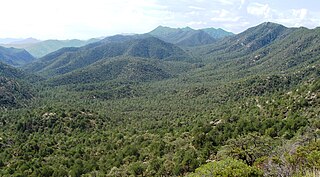
The Santa Catalina Mountains, commonly referred to as the Catalina Mountains or the Catalinas, are north and northeast of Tucson in Arizona, United States, on Tucson's north perimeter. The mountain range is the most prominent in the Tucson area, with the highest average elevation. The highest point in the Catalinas is Mount Lemmon at an elevation of 9,157 feet (2,791 m) above sea level and receives 180 inches (460 cm) of snow annually.

The Prescott National Forest is a 1.25 million acre United States National Forest located in north central Arizona in the vicinity of Prescott. The forest is located in the mountains southwest of Flagstaff and north of Phoenix in Yavapai County, with a small portion extending into southwestern Coconino County. Its administrative offices are in Prescott. There are local ranger district offices in Camp Verde, Chino Valley, and Prescott. The forest includes Lynx Creek where Sam Miller panned for gold and was wounded by a cougar.

Black Mesa National Forest was established as the Black Mesa Forest Reserve by the General Land Office in Arizona on February 22, 1897 with 4,147,200 acres (16,783 km2). After the transfer of federal forests to the U.S. Forest Service in 1905, it became a National Forest on March 4, 1907. On July 1, 1908 the forest was divided among Sitgreaves, Tonto, Apache and Coconino National Forests and the name was discontinued.
Baboquivari National Forest was established as the Baboquivari Forest Reserve by the U.S. Forest Service in Arizona on November 5, 1906 with 126,720 acres (512.8 km2). On March 4, 1907 it became a National Forest, and on July 1, 1908 the entire forest was combined with Huachuca National Forest and Tumacacori National Forest to establish Garces National Forest. The name was discontinued.
Tumacacori National Forest was established as the Tumacacori Forest Reserve by the U.S. Forest Service in Arizona on November 7, 1906 with 203,550 acres (823.7 km2). It became a National Forest on March 4, 1907. On July 1, 1908 the entire forest was combined with Baboquivari National Forest and Huachuca National Forest to establish Garces National Forest, and the name was discontinued. The lands are presently included in Coronado National Forest.
Garces National Forest was established by the U.S. Forest Service in Arizona on July 1, 1908 with 78,480 acres (317.6 km2) from portions of Baboquivari, Tumacacori and Huachuca National Forests. It was named in honor of Franciscan missionary Father Francisco Garcés - an early explorer of southwestern North America including Arizona and southern California. On July 1, 1911 the forest was combined with Coronado National Forest and the name was discontinued.
Blue Mountains National Forest was established as the Blue Mountains Forest Reserve by the U.S. Forest Service in Oregon on March 15, 1906 with 2,675,620 acres (10,827.8 km2) from portions of the Baker City Forest Reserve and other lands. It became a National Forest on March 4, 1907. On March 2, 1908 Maury Mountain Forest Reserve was added to Blue Mountains, and on July 1, 1911 the forest was divided among Whitman, Malheur, Umatilla and Deschutes National Forests and the name was discontinued.
Diamond Mountain National Forest was established as the Diamond Mountain Forest Reserve by the U.S. Forest Service in California on July 14, 1905 with 626,724 acres (2,536.26 km2). It became a National Forest on March 4, 1907. On July 1, 1908 a portion of Diamond Mountain was transferred to Plumas National Forest and the remainder to Lassen National Forest. The name was discontinued.
Chiricahua National Forest was established as the Chiricahua Forest Reserve in Cochise County, Arizona by the General Land Office on July 1, 1902 with 169,600 acres (686 km2). After the transfer of federal forests to the U.S. Forest Service in 1905, it became a National Forest on March 4, 1907. On July 1, 1908 it absorbed Peloncillo National Forest, including lands in Hidalgo County, New Mexico. On July 1, 1917 Chiricahua was absorbed by Coronado National Forest and the name was discontinued.
Peloncillo National Forest was established as the Peloncillo Forest Reserve in Arizona and New Mexico on November 15, 1906 with 178,977 acres (724.29 km2). It became a National Forest on March 4, 1907. On July 1, 1908 it was combined with the Chiricahua National Forest and the name was discontinued. Its lands presently exist as part of the Coronado National Forest.
Mount Graham National Forest was established as the Mount Graham Forest Reserve in Arizona by the General Land Office on July 22, 1902, with 118,600 acres (480 km2). After the transfer of federal forests to the U.S. Forest Service in 1905, it became a national forest on March 4, 1907. On July 1, 1908, part of Mount Graham was combined with Crook National Forest and the remainder was returned to the public domain. The name was discontinued.

Dragoon National Forest was established in Arizona on May 25, 1907, with 69,120 acres (280 km2). On July 1, 1908, it was combined with Santa Catalina National Forest and Santa Rita National Forest to create Coronado National Forest. The name was discontinued.
Santa Catalina National Forest was established as the Santa Catalina Forest Reserve by the General Land Office in Arizona on July 2, 1902 with 155,520 acres (629.4 km2). After the transfer of federal forests to the U.S. Forest Service in 1905, it became a National Forest on March 4, 1907. On July 1, 1908 it was combined with Dragoon National Forest and Santa Rita National Forest to create Coronado National Forest and the name was discontinued.
Santa Rita National Forest was established as the Santa Rita Forest Reserve by the General Land Office in Arizona on April 11, 1902 with 337,300 acres (1,365 km2). After the transfer of federal forests to the U.S. Forest Service in 1905, it became a National Forest on March 4, 1907. On July 1, 1908 it was combined with Santa Catalina National Forest and Dragoon National Forest to create Coronado National Forest and the name was discontinued.
Zuni National Forest was established by the U.S. Forest Service in Arizona and New Mexico on March 2, 1909 with 670,981 acres (2,715.36 km2) from parts of the Zuni and Navajo and other tribal lands. On September 10, 1914 Zuni was transferred to Manzano National Forest. The lands are now part of the Cibola National Forest.
The Pine Mountain and Zaka Lake Forest Reserve was established by the General Land Office in California on March 2, 1892 with 1,644,594 acres (6,655.44 km2) of the San Rafael Mountains in Santa Barbara County, California.
San Francisco Mountains National Forest was established as the San Francisco Mountains Forest Reserve by the General Land Office in Arizona on August 17, 1898 with 975,360 acres (3,947.1 km2). After the transfer of federal forests to the U.S. Forest Service in 1905,it became a National Forest on March 4, 1907. On July 1, 1908 the entire forest was combined with other lands to create Coconino National Forest and the name was discontinued.
The Grand Cañon Forest Reserve was established by the General Land Office in Arizona on February 20, 1893 with 1,851,250 acres (7,491.7 km2). It was renamed Grand Canyon on August 8, 1906 and transferred to the U.S. Forest Service becoming a National Forest on March 4, 1907. On July 1, 1908 the entire forest was divided between Coconino National Forest and the newly established Kaibab National Forest, while other areas were returned to public lands, and the name was discontinued.


