
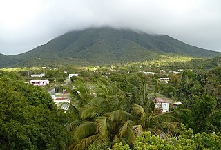
Nevis is an island in the Caribbean Sea that forms part of the inner arc of the Leeward Islands chain of the West Indies. Nevis and the neighbouring island of Saint Kitts constitute the Federation of Saint Kitts and Nevis, a singular nation state. Nevis is located near the northern end of the Lesser Antilles archipelago about 350 kilometres (220 mi) east-southeast of Puerto Rico and 80 kilometres (50 mi) west of Antigua. Its area is 93 square kilometres (36 sq mi) and the capital is Charlestown.

Saint Kitts and Nevis, officially the Federation of Saint Christopher and Nevis, is an island country consisting of the two islands of Saint Kitts and Nevis, both located in the West Indies, in the Leeward Islands chain of the Lesser Antilles. With 261 square kilometres (101 sq mi) of territory, and roughly 48,000 inhabitants, it is the smallest sovereign state in the Western Hemisphere, in both area and population, as well as the world's smallest sovereign federation. The country is a Commonwealth realm, with Charles III as king and head of state.
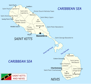
Saint Kitts and Nevis is a twin island country with a total landmass of just 270 square kilometres (104 sq mi). The island of St. Kitts, the larger of the two, is 180 square kilometres (68 sq mi) in size and is located at latitude 17.30 N, and longitude 62.80 W. Nevis is 93 square kilometres (36 sq mi) and located at latitude 17.10 N, longitude 62.35 W, approximately 3 km south-east of St. Kitts. The islands are about one-third of the way from Puerto Rico to Trinidad and Tobago. The islands are volcanic and mountainous.

Basseterre is the capital and largest city of Saint Kitts and Nevis with an estimated population of 14,000 in 2018. Geographically, the Basseterre port is located at 17°18′N62°44′W, on the south-western coast of Saint Kitts Island, and it is one of the chief commercial depots of the Leeward Islands. The city lies within Saint George Basseterre Parish.

Charlestown is the capital of the island of Nevis in the Federation of Saint Kitts and Nevis in the Leeward Islands of the West Indies. Charlestown is situated on the leeward side of the island of Nevis near the southern end of Pinney's Beach.

Saint Christopher-Nevis-Anguilla was a British colony in the West Indies from 1882 to 1983, consisting of the islands of Anguilla, Nevis, and Saint Christopher. From 1882 to 1951, and again from 1980, the colony was known simply as Saint Christopher and Nevis. Saint Christopher and Nevis gained independence in 1983 as the Federation of Saint Kitts and Nevis, while Anguilla would remain a British overseas territory.

Saint Anne Sandy Point is one of 14 administrative parishes that make up Saint Kitts and Nevis. It is the smallest parish on St. Kitts in terms of area, at just 5 square miles (13 km2). It is located on the main island of Saint Kitts and the parish capital is Sandy Point Town.
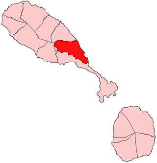
Christ Church Nichola Town is one of 14 administrative parishes that make up Saint Kitts and Nevis. Christ Church Nichola Town is the fifth largest parish on Saint Kitts and is located on the east coast of the main island of Saint Kitts. The parish capital is Nichola Town and its largest town is Molyneux.

Saint George Basseterre is one of 14 administrative parishes that make up Saint Kitts and Nevis. It is the largest parish on Saint Kitts and the second largest parish in Saint Kitts and Nevis. It is by far the most populous parish in the federation, holding nearly a third of the country's population. It is home to the city of Basseterre, capital of Saint Kitts and Nevis, and also has a longer coastline than any other parish in Saint Kitts and Nevis.

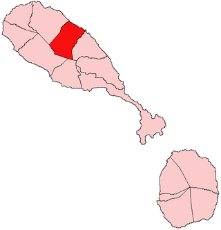
Saint John Capisterre is one of 14 administrative parishes that make up Saint Kitts and Nevis. It is the second largest parish on Saint Kitts, and the third largest parish in the federation. The capital of the parish is Dieppe Bay Town.
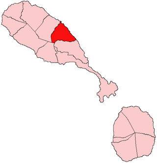
Saint Mary Cayon is one of 14 administrative parishes that make up Saint Kitts and Nevis. It is located on the main island of Saint Kitts and the parish capital is Cayon.
Saint Peter Basseterre is one of 14 administrative parishes that make up Saint Kitts and Nevis. It is located on the main island of Saint Kitts and the parish capital is Monkey Hill.
Saint George Gingerland, also known as Marketshop. St George parish in the southeastern part of the island of Nevis, Leeward Islands, West Indies. It is one of five parishes on the island, and has a total population of about 2,500. The five parishes, in combination with the nine parishes of St. Kitts, make up the fourteen administrative parishes of the two-island Federation of Saint Kitts and Nevis.

Saint James Windward is the largest of five parishes on the island of Nevis. These five parishes are in turn part of the 14 administrative parishes making up the Federation of Saint Kitts and Nevis.

Saint John Figtree is one of five administrative parishes which make up the small Caribbean island of Nevis. These five parishes are part of the fourteen parishes that exist within the Federation of Saint Kitts and Nevis, a two-island country in the Leeward Islands, Lesser Antilles, West Indies.
Saint Paul Charlestown is one of 14 administrative parishes that make up Saint Kitts and Nevis. It is located on the island of Nevis, and the parish capital is Charlestown, which is also capital of the entire island.

Saint Thomas Lowland is one of 5 Nevis parishes which are in turn part of the 14 administrative parishes that make up the Federation of Saint Kitts and Nevis. Leeward Islands, Lesser Antilles, West Indies.

The Southeast Peninsula of Saint Kitts island is located in Saint Kitts and Nevis, in the Lesser Antilles archipelago of the Caribbean.
The Ministry of Foreign Affairs is the ministry responsible for handling the Federation of Saint Kitts and Nevis' external relations and its diplomatic missions abroad. The ministry's current director is Minister of Foreign Affairs and Aviation, Denzil Douglas.

The Christena disaster was a ferry boat shipwreck with 233 casualties that occurred on 1 August 1970 between the islands of St. Kitts and Nevis in the Leeward Islands, West Indies.

