
A dune is a landform composed of wind- or water-driven sand. It typically takes the form of a mound, ridge, or hill. An area with dunes is called a dune system or a dune complex. A large dune complex is called a dune field, while broad, flat regions covered with wind-swept sand or dunes, with little or no vegetation, are called ergs or sand seas. Dunes occur in different shapes and sizes, but most kinds of dunes are longer on the stoss (upflow) side, where the sand is pushed up the dune, and have a shorter slip face in the lee side. The valley or trough between dunes is called a dune slack.

Deepwater is a coastal national park in Queensland, Australia, 375 km north of Brisbane. It protects an area of sand dunes and coastal heaths in the Deepwater Creek catchment. The area is one of the few remaining pristine freshwater catchments on Queensland's east coast. Deepwater National Park was established in 1988 and covers 4,090 ha.

A sandhill is a type of ecological community or xeric wildfire-maintained ecosystem. It is not the same as a sand dune. It features very short fire return intervals, one to five years. Without fire, sandhills undergo ecological succession and become more oak dominated.

Bacton is a village and civil parish in Norfolk, England. It is on the Norfolk coast, some 12 miles (20 km) south-east of Cromer, 25 miles (40 km) north-west of Great Yarmouth and 19 miles (30 km) north of Norwich. Besides the village of Bacton, the parish includes the nearby settlements of Bacton Green, Broomholm, Keswick and Pollard Street. It also includes Edingthorpe, which was added to Bacton civil parish under the County of Norfolk Review Order, 1935.

Golden Bay is an outer southern suburb of Perth, the capital city of Western Australia, located within the City of Rockingham. The suburb is located between Secret Harbour and Singleton, and just off the Mandurah Road. Originally known as Peelhurst, the locality name was officially changed in 1985. Golden Bay shore is a segment of the Swan Coastal Plain, which runs along the coast of the Indian Ocean.

The Swan Coastal Plain in Western Australia is the geographic feature which contains the Swan River as it travels west to the Indian Ocean. The coastal plain continues well beyond the boundaries of the Swan River and its tributaries, as a geological and biological zone, one of Western Australia's Interim Biogeographic Regionalisation for Australia regions. It is also one of the distinct physiographic provinces of the larger West Australian Shield division.

Sandy Island Beach State Park is a New York State park on the eastern shore of Lake Ontario. Its highlight is a 1,500-foot (460 m) natural sandy beach. The park is near the southern end of a notable 17-mile (27 km) length of sandy shoreline, coastal dunes, and wetlands ; a 1959 study noted that "The eastern end of Lake Ontario contains not only the finest beaches on the entire lake but also the finest wildlife habitat."

Sand dune stabilization is a coastal management practice designed to prevent erosion of sand dunes. Sand dunes are common features of shoreline and desert environments. Dunes provide habitat for highly specialized plants and animals, including rare and endangered species. They can protect beaches from erosion and recruit sand to eroded beaches. Dunes are threatened by human activity, both intentional and unintentional. Countries such as the United States, Australia, Canada, New Zealand, the United Kingdom, and Netherlands, operate significant dune protection programs.

Hampton is an interim Australian bioregion located in southeastern coastal Western Australia, with a small portion (4%) extending into adjacent South Australia. It has an area of 1,088,198 hectares. The Hampton bioregion is part of the Coolgardie woodlands ecoregion.

Jockey's Ridge State Park is a North Carolina state park in Dare County, North Carolina in the United States. Located in Nags Head, North Carolina, it covers a 427-acre (1.73 km2) area, and includes the tallest active sand dune system in the eastern United States. It is the most visited park within the NC park system. The park is a day-use only park and has no campgrounds. Jockey's Ridge contains three unique ecosystems: the Roanoke Sound, the dune system, and the maritime forest. Often when it rains, water collects near the bottom of the dunes creating temporary ponds known as vernal pools. Few fauna can be seen around the dunes, although some types of flora, such as tall grass, may be seen near the bottom of the dunes.

The Naracoorte woodlands is an ecoregion in southern Australia. It covers the Naracoorte coastal plain in southeastern South Australia and southwestern Victoria. It is coterminous with the Naracoorte Coastal Plain IBRA region. Only 10% of the ecoregion's area still has its original vegetation; most has been converted to agriculture and pasture.
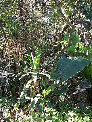
KwaZulu-Natal Dune Forest is a subtropical forest type that was once found almost continuously along the coastal dunes of KwaZulu-Natal, South Africa. This vegetation type develops in sheltered areas behind the littoral zone, where with some protection from the salt wind it may develop with canopies as tall as 30 m. It still exists in protected areas, but much has been degraded by human activity. Coastal dune forest covers approximately 1% of the land area of KwaZulu-Natal, and is a habitat type seriously threatened from human population pressure and development, particularly titanium mining.
Cape Flats Dune Strandveld is an endangered vegetation type. This is a unique type of Cape Strandveld that is endemic to the coastal areas around Cape Town, including the Cape Flats.

Cape Flats Sand Fynbos (CFSF), previously known as Sand Plain Fynbos, is a critically endangered vegetation type that occurs only within the city of Cape Town. Less than 1% of this unique lowland fynbos vegetation is conserved.
Lake Newland Conservation Park is a protected area in the Australian state of South Australia located on the west coast of the Eyre Peninsula about 10 kilometres (6.2 mi) north of the town of Elliston. It was proclaimed in 1991 in order to protect Lake Newland, a hypersaline lake, and an associated wetland complex. It lies in the traditional lands of the Wirangu people.
Vivonne Bay Conservation Park, formerly the Vivonne Bay National Park, is a protected area in the Australian state of South Australia located on the south coast of Kangaroo Island in the gazetted locality of Vivonne Bay. It was dedicated in 1971 to conserve coastal country containing vegetation not already protected in Kelly Hill Conservation Park.
Lincoln Conservation Park is a protected area in the Australian state of South Australia located in the Eyre Peninsula in the gazetted locality of Tulka on land in the Section 490 in the cadastral unit of Hundred of Lincoln about 15 kilometres south west of Port Lincoln.

Smaills Beach is a beach on the Pacific Ocean 7.6 kilometres (4.7 mi) southeast of the city centre of Dunedin, New Zealand. Located within the Ocean Grove Reserve adjacent to Tomahawk Beach, at the point where Otago Peninsula joins the mainland of the South Island, Smaills Beach is a white sand beach for much of its length, but its western end is covered in volcanic boulders. Just offshore from the beach, dominating the wave patterns of the surf, is the rocky outcrop known as Bird Island. Smaills Beach is clothing-optional, renowned for its wildlife, and popular with surfers.

Ship Creek is a small river that flows into an area of coastal swamp forest on the West Coast of New Zealand's South Island. Ship Creek is approximately 11 km (6.8 mi) long and flows northwest from catchment areas on the slopes of Bald Hill, reaching the Tasman Sea around 20 km (12 mi) north-east of Haast. Near the mouth of Ship Creek, there are short walks around dune lakes and ancient kahikatea swamp forest.
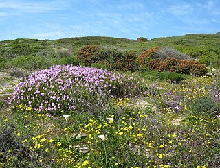
 Dune vegetation in the Pipeline Coastal Park.
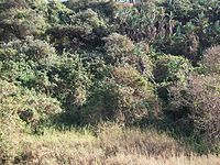 Coastal vegetation.
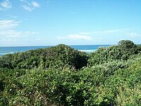
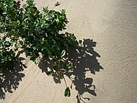 A sand dune.
 A ghost crab.
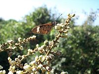 An Acraea on Deinbollia oblongifolia flowers.


