
Maribor is the second-largest city in Slovenia and the largest city of the traditional region of Lower Styria. It is also the seat of the City Municipality of Maribor.

The Dravinja is the largest tributary of the Drava River in Slovenia. It is 73 kilometres (45 mi) long. Its source is on the Pohorje Massif southwest of Mount Rogla about 1,150 m above sea level. The river passes Zreče, the town of Slovenske Konjice, the ruins of the fort at Zbelovo, Poljčane, Makole, Štatenberg Castle, Majšperk, and Videm pri Ptuju, where it merges with the Drava. Its main tributary is the river Polskava.

Lovrenc na Pohorju is a settlement in northeastern Slovenia. It lies in the Pohorje Hills to the west of Maribor. The area is part of the traditional region of Styria. It is now included in the Drava Statistical Region. It is the seat of the Municipality of Lovrenc na Pohorju.

Ribnica na Pohorju is a settlement and a municipality in northern Slovenia. It lies in the Pohorje Hills west of Maribor. The area was part of the traditional region of Styria. It is now included in the Carinthia Statistical Region.

Pohorje, also known as the Pohorje Massif or the Pohorje Mountains, is a mostly wooded, medium-high mountain range south of the Drava River in northeastern Slovenia. According to the traditional AVE classification it belongs to the Southern Limestone Alps. Geologically, it forms part of the Central Alps and features silicate metamorphic and igneous rock. Pohorje is sparsely populated with dispersed villages. There are also some ski resorts.
The Hudinja is a river in Styria, Slovenia. The river is 32 kilometres (20 mi) in length. Its source is on the Pohorje Massif southwest of Mount Rogla, about 1380 m above sea level, near the source of Dravinja River. The river passes Vitanje, Socka Castle, Vojnik, and Celje, where it flows into the Voglajna. A district of Celje also named Hudinja lies on the river.
The Oplotniščica or Oplotnica is a river in Styria, Slovenia. The river is 28 kilometres (17 mi) in length. Its source is on the Pohorje Massif, northeast of Mount Rogla. It passes Osankarica, Lukanja, and Cezlak, runs through Oplotnica and Tepanje, and then merges with the Dravinja near Žiče.
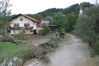
Fram Creek is a stream in Styria, Slovenia. It is 26 kilometres (16 mi) in length. Its source is on the Pohorje Massif, near Sveti Areh in the Maribor Pohorje Ski Resort. It passes Fram and Rače and merges with other streams of the Drava Plain and joins the Polskava River near Župečja Vas.

Koroška Vas na Pohorju is a settlement in the foothills of the Pohorje range in the Municipality of Zreče in northeastern Slovenia. It is part of the traditional region of Styria and is now included with the rest of the municipality in the Savinja Statistical Region.

Kot na Pohorju is a dispersed settlement in the Municipality of Slovenska Bistrica in northeastern Slovenia. It lies in the Pohorje Hills north of Oplotnica. The area is part of the traditional region of Styria. It is now included with the rest of the municipality in the Drava Statistical Region.
Ogljenšak is a settlement in the Municipality of Slovenska Bistrica in northeastern Slovenia. The area is part of the traditional region of Styria. It lies in the foothills of the Pohorje range, just north of Zgornja Polskava. It is now included with the rest of the municipality in the Drava Statistical Region.

Spodnja Polskava is a settlement in the Municipality of Slovenska Bistrica in northeastern Slovenia. The area is part of the traditional region of Styria. It is now included with the rest of the municipality in the Drava Statistical Region.

Šmartno na Pohorju is a village in the Pohorje Hills in the Municipality of Slovenska Bistrica in northeastern Slovenia. The area is part of the traditional region of Styria. It is now included with the rest of the municipality in the Drava Statistical Region.
Rdeči Breg is a dispersed settlement in the Municipality of Lovrenc na Pohorju in northeastern Slovenia. It extends from the right bank of the Drava River in the Pohorje Hills and part of the settlement lies in the adjacent Municipality of Podvelka. The area was part of the traditional region of Styria. It is now included in the Drava Statistical Region.

Ruta is a dispersed settlement in the Pohorje Hills above the right bank of the Drava River in the Municipality of Lovrenc na Pohorju in northeastern Slovenia. Traditionally the area was part of Styria. It is now included in the Drava Statistical Region.

Sveti Primož na Pohorju is a settlement in the Municipality of Vuzenica in northern Slovenia. It lies south of the town of Vuzenica, a dispersed settlement in the western Pohorje Hills. Traditionally the area was part of Styria. It is now included in the Carinthia Statistical Region.
The South Pohorje dialect is a Slovene dialect in the Styrian dialect group. It is spoken south of the Drava River, starting east of Ruše and extending through Maribor to just before Zlatoličje, and extending as far south as the Slovenske Konjice area. It also includes the settlements of Rače, Spodnja Polskava, Slovenska Bistrica, and Vitanje.

Anton Ingolič was a Slovene writer, playwright, and editor. He is best known for his novels and youth literature.

The Municipality of Lovrenc na Pohorju is a municipality in northeastern Slovenia. It lies in the Pohorje Hills to the west of Maribor. The area was part of the traditional region of Styria. It is now included in the Drava Statistical Region. The settlement of Lovrenc na Pohorju is the seat of the municipality.

The Municipality of Miklavž na Dravskem Polju is a small municipality in northeastern Slovenia. It lies on the right bank of the Drava River southeast of Maribor. The seat of the municipality is the settlement of Miklavž na Dravskem Polju. The area was part of the traditional region of Lower Styria. It is now included in the Drava Statistical Region.


