Related Research Articles

The Stikine River is a river, historically also the Stickeen River, approximately 610 kilometres (380 mi) long, in northwestern British Columbia in Canada and in southeast Alaska in the United States.

The Stickeen Territories, also colloquially rendered as Stickeen Territory,Stikine Territory, and Stikeen Territory, was a territory of British North America whose brief existence began July 19, 1862, and concluded July of the following year. The region was split from the North-Western Territory in the wake of the Stikine Gold Rush. The initial strike attracted large numbers of miners — mostly American — to the region; by detaching the region from the exclusive trade zone of the Hudson's Bay Company, British authorities were able to impose tariffs and licences on the speculators. The new territory, named after the Stikine River, was under the responsibility of the Governor of the Colony of British Columbia, James Douglas, who was appointed "Administrator of the Stickeen Territories" and under British law, within the jurisdiction of the Supreme Court of British Columbia.
The basin of the Shuswap River lies northeast of the Okanagan Valley in British Columbia, originating in the central Monashee Mountains. It is the upper part of the drainage better known to British Columbians as belonging to Shuswap Lake and the South Thompson River. The river's drainage basin is over 1,969 square kilometres (760 sq mi) in area.
Johnstone Creek Provincial Park is a provincial park in British Columbia, Canada, located west of the confluence of Rock Creek and the Kettle River and the town of Rock Creek. The park has a roughly 38 hectare area, and is near to the Crowsnest Highway.
Stuart River Provincial Park is a provincial park in British Columbia, Canada. It is located in two sections north and northwest of Vanderhoofalong the Stuart River southeast of Stuart Lake and the city of Fort St. James. The upper section is located at 54°13′20″N124°00′00″W and comprises c.7391 ha. while the lower, eastern section is centred at 54°03′00″N123°37′00″W and comprises c.3390 ha. and is within the Greater Prince George area. The upper site, which is located around the confluence of the Stuart and Nechako Rivers, includes the site of Chinlac, a Dakelh village whose inhabitants were massacred and enslaved by the Tsilhqot'in of Anahim Lake c. 1745.
The Stikine Ranges are a group of mountain ranges and mountainous plateaus in northwestern British Columbia, Canada. They are the northernmost subdivision of the Cassiar Mountains and among the least explored and most undeveloped parts of the province.

The Lil'wat First Nation, a.k.a. the Lil'wat Nation or the Mount Currie Indian Band, is a First Nation band government located in the southern Coast Mountains region of the Interior of the Canadian province of British Columbia. It is a member of the Lillooet Tribal Council, which is the largest grouping of band governments of the St'at'imc or Stl'atl'imx people. Other St'at'imc governments include the smaller In-SHUCK-ch Nation on the lower Lillooet River to the southwest, and the independent N'quatqua First Nation at the near end of Anderson Lake from Mount Currie, which is the main reserve of the Lil'wat First Nation, and also one of the largest Indian reserves by population in Canada.
Klootchman Canyon is a canyon on the Stikine River in northwestern British Columbia, Canada, located south of a bend in the river known as the Devil's Elbow.
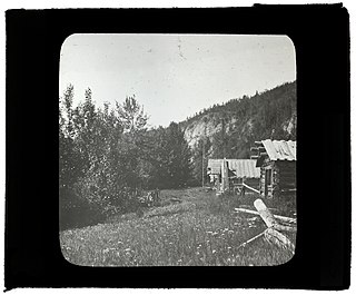
Glenora, also known historically as the Hudson's Bay Company's Fort Glenora and during the Cassiar Gold Rush as Glenora Landing, was an unincorporated settlement in the Stikine Country of northwestern British Columbia, Canada. It was located on the banks of the Stikine River, just southwest and approximately 13 miles downstream from the community of Telegraph Creek.
The Tahltan First Nation, also known as the Tahltan Indian Band, is a band government of the Tahltan people. Their main community and reserves are located at Telegraph Creek, British Columbia. Their language is the Tahltan language, which is an Athabaskan language also known as Nahanni, is closely related to Kaska and Dunneza. Their Indian and Northern Affairs Canada band number is 682. The Tahltan First Nation is joined with the Iskut First Nation in a combined tribal council-type organization known as the Tahltan Nation.

The Iskut River is the largest tributary of the Stikine River in northwestern British Columbia, Canada, entering it a few miles above its entry into Alaska.
The Spatsizi River is a tributary of the Stikine River, rising near Mount Gunanoot in the southeastern Spatsizi Plateau, British Columbia.
The Chutine River, originally named the Clearwater River, is a major right tributary of the Stikine River in northwestern British Columbia, Canada. It is located west of the Stikine Icecap and just inside the boundary between Alaska and British Columbia. The former settlement of Chutine or Chutine Landing is located at the confluence of the Chutine and Stikine. The name means "half-people" in the Tahltan language.
The Choquette River is a tributary of the Stikine River, flowing west into that river just north of its confluence with the Iskut. The river is named for Alexander "Buck" Choquette, discoverer of the strike which launched the Stikine Gold Rush and the first non-native settler in the region, who operated a store near here and also for a while the Hudson'a Bay Company post and border station at Stikine, then named Boundary. The Choquette Glacier, at the head of the river and its source, and Mount Choquette are nearby; Mount Johnny in the same region is named for one of Choquette's many sons.
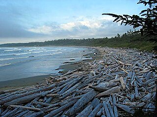
Long Beach is the largest and longest beach in the Pacific Rim National Park Reserve on the west coast of Vancouver Island, British Columbia, Canada. It is located on Wickaninnish Bay between Tofino (NW) and Ucluelet (SE) and is adjoined by campgrounds and picnic areas. The Tofino-Ucluelet highway parallels the entirety of the beach. The beach's consistent surf, exposed to the open Pacific Ocean, established it as one of the earliest and most popular surfing locations in British Columbia.
Tahltan Indian Reserve No. 10, referred to by Statistics Canada for census purposes as Tahtlan 10, is an Indian Reserve of the Tahltan First Nation located one mile north of the confluence of the Klastline River with the Stikine in the Stikine Country of the northwestern British Columbia Interior of Canada.
The Stikine Gold Rush was a minor but important gold rush in the Stikine Country of northwestern British Columbia, Canada. The rush's discoverer was Alexander "Buck" Choquette, who staked a claim at Choquette Bar in 1861, just downstream from the confluence of the Stikine and Anuk Rivers, at approximately 56°48′N131°46′W. Choquette was the son-in-law of the Tlingit chief Chief Shakes, who presided over the region at the mouth of the river, the site of the former Fort Stikine and today's city of Wrangell, Alaska, and had also explored the Nass and several other rivers.
The Klappan River is a major tributary of the Stikine River in northwestern British Columbia, Canada. It flows north from an area known as the Sacred Headwaters, which is the source not only of this river but also of the Nass, Skeena, Spatsizi and Stikine Rivers. The headwaters region is the site of a controversial coal-bed methane project.
The Leq' a: mel First Nation, formerly known as the Lakahahmen First Nation, is a First Nations band government whose community and offices are located in the area near Deroche, British Columbia, Canada, about 12 kilometres east of the District of Mission. They are a member government of the Sto:lo Nation Chiefs Council, which is one of two tribal councils of the Sto:lo.
Cornice Mountain, 1503 m, is a mountain in the Stikine Icecap area of the Boundary Ranges in northwestern British Columbia, Canada. It is located southwest of the confluence of the Flood and Stikine Rivers.
References
Coordinates: 57°03′00″N131°43′00″W / 57.05000°N 131.71667°W