
The Briare Canal is one of the oldest canals in France. Its construction started in 1604. It was the first summit level canal in Europe that was built using pound locks, connecting the Loire and Seine valleys. It is 57 kilometres long and is part of the Bourbonnais route from Saint-Mammès on the Seine to Chalon-sur-Saône on the Saône.
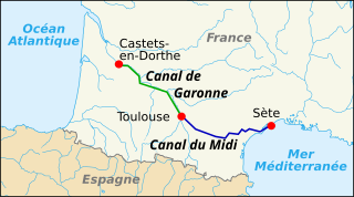
The Canal des Deux Mers has been used to describe two different but similar things since the 1660s. In some cases, it is used interchangeably with the Canal du Midi. In others, it describes the path from the Atlantic to the Mediterranean, of which the Canal du Midi was the first man-made component.

The Canal de Brienne is a French canal connecting the Garonne River with the Canal du Midi and the Canal de Garonne. It has two locks. The lock opening to the Garonne is known as Ecluse Saint-Pierre. The lock nearer to the Canal du Midi usually stands open.
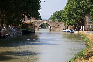
Le Somail is a hamlet in the Aude department of southwestern France. Le Somail is located along the Canal du Midi. Its territory is shared by 3 communes: Ginestas, Saint-Nazaire-d'Aude and Sallèles-d'Aude.

The Grand Bassin is the largest body of open water along the Canal du Midi. It is in Castelnaudary, France and covers some 7 hectares. Once a scene of intense economic activity, it is now a major pleasure port used by tourist craft. It holds the water reserve for the four locks of Saint-Roche.
Ouvrages du Libron is a structure like no other on the Canal du Midi. It allows the Libron River, near Agde in south-west France, to traverse the Canal du Midi. At the point of intersection, the Libron is more or less at the same level as the Canal du Midi so a traditional aqueduct was not an option. The problem was further exacerbated by the Libron's propensity to flash flood up to twenty times a year. The problem was originally solved by the building of a pontoon aqueduct known as the Libron Raft which utilised a flush-decked barge to protect the canal channel in times of flooding. However, this was replaced by the present structure in 1855.
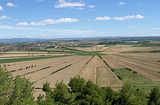
The Seuil de Naurouze, or Col de Naurouze, is the highest point of the Canal du Midi in southern France. It is the watershed point identified by Pierre-Paul Riquet when he designed and built the canal. Water falling on the western side of this point flows to the Atlantic Ocean and on the eastern side to the Mediterranean Sea. It is on the border of the department of Haute-Garonne and the department of the Aude.
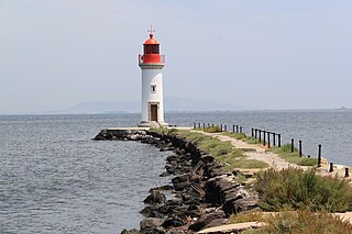
The Les Onglous Lighthouse is the terminating point of the Canal du Midi where the canal enters the Étang de Thau. The red and white lighthouse is at the tip of a short jetty projecting into the Étang de Thau. It is located on the east jetty at the canal entrance, about 1.5 km (0.93 mi) south of Marseillan in the Hérault department. The Isthmus of Onglous is a narrow strip of land between the Étang and the Mediterranean.
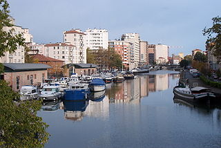
The Port Saint-Sauveur is one of the two river ports located in Toulouse on the Canal du Midi. The other being the Port de l'Embouchure.

The Ecluse Saint-Pierre is one of two locks on the Canal de Brienne. Also known as Garonne lock, in French: Ecluse de Garonne.

Port de la Robine is located at PK168 on the Canal du Midi immediately adjacent to the Truilhas Bridge. The turn for the La Nouvelle branch is .5 km (1,600 ft) north east and the Cesse aqueduct .5 km (1,600 ft) south west.
The Étang de Montady is a drained pond or lagoon, or more accurately a former freshwater wetland, located near Montady and Colombiers, midway between Béziers and Narbonne in the western department of Hérault in southern France.

The Capestang bridge over the Canal du Midi at PK 189 at Capestang is a very important structure for those wishing to motor on the canal. It is used as a measuring device as it is the lowest structure on the canal. A boat, with an air draft under 3.3 m (11 ft) at the center and assuming a beam no more than 5 m (16 ft), a height of no more than 2.4 m (7.9 ft) at the extremities, should make it under the bridge. A British boat builder who builds boats for several of the boat hire companies in France builds their boats to meet these requirements.
The Ognon Aqueduct is one of several aqueducts on the Canal du Midi. It was built in 1826-27 to replace the troublesome level crossing of the Ognon River.
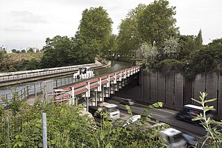
The Herbettes Aqueduct is one of several aqueducts on the Canal du Midi. In Toulouse France, it carries the canal over a four-lane highway in a metal trough. The trough has been colorfully painted underneath. The aqueduct is about 2 km (1.2 mi) from the Port Saint-Sauveur.
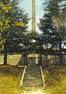
The Riquet Obelisk is dedicated to the creator of the Canal du Midi, Pierre-Paul Riquet. In 1827, the heirs of Riquet built the monument. The obelisk has a dedication: "To Pierre-Paul Riquet, Baron Bonrepos, author of the Two Seas Canal in Languedoc". It is erected near the site of the former octagonal holding tank, called the Bassin de Naurouze, created during the building of the Canal du Midi.
The Bourbonnais route is a connection of four canals in France from Saint-Mammès on the Seine to Chalon-sur-Saône on the Saône River: It includes the Canal du Loing, Canal de Briare, Canal lateral a la Loire, and Canal du Centre.

The Canal de la Somme is a canal in northern France. Its total length is 156.4 km with 25 locks, from the English Channel at Saint-Valéry-sur-Somme to the Canal de Saint-Quentin at Saint-Simon.

The Canal de Beaucaire was a canal in southern France. It is now part of the Canal du Rhône à Sète along with the Canal des Ètangs. The originator was to be the Marshal de Noailles. However he did nothing and his concession was revoked. It was then granted to a company formed by Marshal de Richelieu, but again, nothing was accomplished until the state of Languedoc took over. Construction was finally begun in 1777 and completed in 1808. It was to connect the city of Aigues-Mortes to the Rhone.


