Porto Formoso

Last updated
Porto Formoso
Civil Parish
Porto Formoso, Ribeira Grande, ilha de Sao Miguel, Acores.JPG
The expanse of tea fields from the regional roadway looking towards the coastal community of Porto Formoso
Official name:Freguesia do Porto Formoso
Country Flag of Portugal.svg  Portugal
Autonomous Region Flag of the Azores.svg  Azores
Island São Miguel
Municipality Ribeira Grande
Localities Ladeira da Velha,Porto Formoso
River Ribeira dos Moinhos
Center Porto Formoso
 - elevation 35 m (115 ft)
 - coordinates 37°49′19″N25°25′32″W / 37.82194°N 25.42556°W / 37.82194; -25.42556 Coordinates: 37°49′19″N25°25′32″W / 37.82194°N 25.42556°W / 37.82194; -25.42556
Highest point
 - location Espigão da Ovelha
 - elevation 884 m (2,900 ft)
 - coordinates 37°46′42″N25°26′28″W / 37.77833°N 25.44111°W / 37.77833; -25.44111
Lowest point Sea Level
 - location Atlantic Ocean
Area 12.79 km2 (5 sq mi)
 - urban .37 km2 (0 sq mi)
Population 1,265 (2011)
Density 99/km2 (256/sq mi)
Settlement fl. 1509
 -  Parish 2 June 1509
LAU Junta Freguesia
 - location Rua Padre João B. Couto
 - elevation 28 m (92 ft)
 - coordinates 37°49′22″N25°25′39″W / 37.82278°N 25.42750°W / 37.82278; -25.42750
President Junta Emanuel Janeiro Faria
Timezone Azores (UTC-1)
 - summer (DST) Azores (UTC0)
Postal Zone 9625-429
Area Code & Prefix (+351) 292 XXX-XXXX
Patron Saint Nossa Senhora da Graça
Wikimedia Commons: Porto Formoso (Ribeira Grande)
Geographic detail from Instituto Geográfico Português (2010)

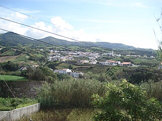
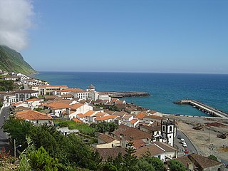
Porto Formoso is a civil parish in the municipality of Ribeira Grande in the Portuguese archipelago of the Azores. The population in 2011 was 1,265, [1] in an area of 12.79 km². [2]

Portugal Republic in Southwestern Europe

Portugal, officially the Portuguese Republic, is a country located mostly on the Iberian Peninsula in southwestern Europe. It is the westernmost sovereign state of mainland Europe, being bordered to the west and south by the Atlantic Ocean and to the north and east by Spain. Its territory also includes the Atlantic archipelagos of the Azores and Madeira, both autonomous regions with their own regional governments.

Azores Portuguese archipelago in the North Atlantic Ocean

The Azores, officially the Autonomous Region of the Azores, is one of the two autonomous regions of Portugal. It is an archipelago composed of nine volcanic islands in the North Atlantic Ocean about 1,360 km (850 mi) west of continental Portugal, about 1,643 km (1,021 mi) west of Lisbon, in continental Portugal, about 1,507 km (936 mi) northwest of Morocco, and about 1,925 km (1,196 mi) southeast of Newfoundland, Canada.

Contents

History

The ornate facada and staircase of the parochial Church of Nossa Senhora da Graca Igreja Nossa Senhora da Graca, Porto Formoso, Ribeira Grande, ilha de Sao Miguel, Acores.JPG
The ornate facada and staircase of the parochial Church of Nossa Senhora da Graça

The establishment of this civil parish remotes to the early part of the 16th century, as first recorded by Pedro Vaz Pacheco. [3] On 2 June 1509, he ordered the construction of a Chapel of Bom Jesus, to serve his descendents. [3] By the end of that century, the chapel had its own clergy, passing into a vicarage in 1568.

Gaspar Frutuoso (in Saudades da Terra), refers to the parish in these terms: "it makes a beautiful bay, and in the centre the locality of Porto Formoso, named for the things that exist there, it is clean and the best one in the north...". [3]

The parochial church's patron is Nossa Senhora da Graça (Our Lady of Grace), and existed by the time that Pedro Vaz Pacheco ordered the erection of the Chapel of Bom Jesus (which included a crucifix and chanel to the Virgin[ clarification needed ]) as a burial tomb for his descendents. [3] The church was renovated throughout the centuries, becoming the simple facade of basalt rock and three interior naves. [3]

In the civil parish, in the old roadway that connected Ribeira Grande to Furnas, is an obelisk (Obelisco da Ladeira da Velha) which was erected during the Liberal Wars (1829–34) to mark a long-forgotten engagement in the conflict, known as the Battle of Ladeira da Velha. [3]

Battle of Ladeira da Velha

The Battle of Ladeira da Velha was fought on August 3, 1831, between Portuguese Liberal and Miguelite forces on São Miguel Island in the Azores, as part of the Portuguese civil war. It ended in a Liberal victory, which put the island and the rest of the Archipelago under Liberal control.

Geography

A partial view of the built-up area of the village of Praia Formoso, looking over into the fishing port/beach Porto Formoso, vista parcial, Ribeira Grande, ilha de Sao Miguel, Acores.JPG
A partial view of the built-up area of the village of Praia Formoso, looking over into the fishing port/beach
The beach and cliffs of the Praia dos Moinhos, one of the few white-sand beaches on the island of Sao Miguel SMG RBG PFo praiaPortoFormoso sand.jpg
The beach and cliffs of the Praia dos Moinhos, one of the few white-sand beaches on the island of São Miguel

In the area of Praia dos Moinhos, a beach within an amphitheatre-like cliff face, the popular beach and locality developed from several watermills that were built along the ravine that flows into the ocean.

The ravine continues to empty into the ocean on this site, dividing he white-sand beach, which is popular with tourists and local residents. [3] Immediately near the beach is the Ladeira da Velha, where a natural mineral spring, rich in potassium, erupts from the coast with temperatures around 30°C. [3] A thermae was constructed in a small house to provide repose for people who took therapeutic mineral treatments from these waters. [3]

Economy

The region is best known for the tea factories that exist in the vicinity of one another: the Fábrica de Chá Porto Formoso, within Porto Formoso, and the neighbouring Gorreana tea factory in the neighbouring parish of São Brás. [3] [4] The terrain in this parish is devoted to agriculture and as pasture-lands, but several tracts are dedicated to the cultivation of tea plants, owing to the areas micro-climate. [3]

Architecture

Religious

Related Research Articles

Praia da Vitória Municipality in Azores, Portugal

Praia da Vitória, translated as the Beach of the Victory, is a municipality in the Portuguese archipelago of the Azores. With a population of 21,035, the second largest administrative authority on the island of Terceira, it covers an area of 161.27 square kilometres (62.27 sq mi), that extends from the northern coast halfway into the interior.

Conceição (Horta) Civil Parish in Azores, Portugal

Conceição is a freguesia in the municipality of Horta in the Portuguese Azores. The population in 2011 was 1,138, in an area of 3.08 km². It is the second smallest parish within the administration of Horta.

Lagoa, Azores Municipality in Azores, Portugal

Lagoa is a municipality in the southwestern part of São Miguel Island in the Azores. The population in 2011 was 14,442, in an area of 45.59 km². Lagoa is located east of Ponta Delgada, the island capital.

Ribeira Chã Civil Parish in Azores, Portugal

Ribeira Chã is a civil parish in the municipality of Lagoa in the Portuguese archipelago of the Azores. It is located along a cliff that overlooks the Atlantic Ocean. The population in 2011 was 396, in an area of 2.50 km². Ribeira Chã is the smallest parish by population and area in the municipality of Lagoa.

Ribeira Grande, Azores Municipality in Azores, Portugal

Ribeira Grande is a municipality in the northern part of the island of São Miguel in the Portuguese Azores. The population in 2011 was 32,112, in an area of 180.15 km². The municipal seat is located in the civil parish of Matriz, with a population of about 4000 inhabitants, part of the urbanized core of what is commonly referred to as the city of Ribeira Grande.

Lomba da Maia is a civil parish in the municipality of Ribeira Grande in the Portuguese Azores. The population in 2011 was 1,152, in an area of 20.47 km2. It is situated on a plateau that overlooks the northern coast and the neighboring parish of Maia.

Maia (Ribeira Grande) Civil Parish in Azores, Portugal

Maia is a civil parish in the municipality of Ribeira Grande in the Portuguese archipelago of the Azores. The population in 2011 was 1,900, in an area of 21.97 km². Maia is the largest parish by area in Ribeira Grande.

Ribeira Seca (Ribeira Grande) Civil Parish in Azores, Portugal

Ribeira Seca is a civil parish in the municipality of Ribeira Grande in the Portuguese archipelago of the Azores. The population in 2011 was 2,950, in an area of 12.59 km². It is located near the north coast of the island.

Vila Franca do Campo Municipality in Azores, Portugal

Vila Franca do Campo is a town and municipality in the southern part of the island of São Miguel in the Portuguese Autonomous Region of the Azores. The population of the municipality was 11,229 in 2011, in an area of 77.97 km². The town proper, which incorporates the urbanized parishes São Miguel and São Pedro, has 4100 inhabitants.

Povoação, Azores Municipality in Azores, Portugal

Povoação is a municipality located in the southeastern corner of the island of São Miguel in the Portuguese archipelago of the Azores. The population in 2011 was 6,327, in an area of 106.41 km².

Água Retorta Civil Parish in Azores, Portugal

Água Retorta is a civil parish in the municipality of Povoação, on the island of São Miguel in the Portuguese archipelago of the Azores. The population in 2011 was 489, in an area of 12.55 km². Situated along the southeast coast, it is the smallest and most eastern parish in the municipality.

Nossa Senhora may refer to the following places:

Almagreira (Vila do Porto) Civil Parish in Azores, Portugal

Almagreira is a civil parish in the municipality of Vila do Porto on the island of Santa Maria, in the Portuguese autonomous region of Azores. The population in 2011 was 599, in an area of 11.22 km². Bordering all other parishes of the island, it is located northwest of Vila do Porto.

Campanário, Madeira Civil Parish in Madeira, Portugal

Campanário is a civil parish in the municipality of Ribeira Brava in the Portuguese island of Madeira. The population in 2011 was 4,582, in an area of 11.74 km².

Mangualde Municipality in Centro, Portugal

Mangualde is a municipality in the subregion of Dão-Lafões, central region of Portugal. The population in 2011 was 19,880, in an area of 219.26 km2.

Santa Cruz (Coimbra) Civil Parish in Centro, Portugal

Santa Cruz is a former civil parish in the municipality of Coimbra, Portugal. In 2013, the parish merged into the new parish Coimbra. In 2001, its population was 6866 inhabitants, in an area of 5.56 km² that parallels the north (right) margin of the Mondego River, extending to the village of Adémia in Trouxemil.

Povoação (parish) Civil parish in Azores, Portugal

Povoação is a civil parish in the municipality (concelho) of Povoação, on the island of São Miguel in the Portuguese archipelago of the Azores. The population in 2011 was 2,161, in an area of 26.23 km².

References

  1. Instituto Nacional de Estatística
  2. Eurostat
  3. 1 2 3 4 5 6 7 8 9 10 11 Câmara Municipal, ed. (2011), Historia (in Portuguese), Porto Formoso (Ribeira Grande), Portugal: Câmara Municipal de Ribeira Grande, retrieved 1 October 2011
  4. Tea Producing Nations: Europe: Portugal