
Lake Travis is a reservoir on the Colorado River in central Texas in the United States. The reservoir was formed in 1942 by the construction of Mansfield Dam on the western edge of Austin, Texas by the Lower Colorado River Authority (LCRA), and was built specifically to contain floodwaters in a flash-flood prone region. During its construction, after a severe flood in July 1938, the height of the dam was raised to add storage capacity for floodwaters.

Lake Mead is a man made lake that lies on the Colorado River, about 24 mi (39 km) from the Las Vegas Strip, southeast of the city of Las Vegas, Nevada, in the states of Nevada and Arizona. It is the largest reservoir in the United States in terms of water capacity. Formed by the Hoover Dam on September 30, 1935, the reservoir serves water to the states of Arizona, California, and Nevada, as well as some of Mexico, providing sustenance to nearly 20 million people and large areas of farmland.
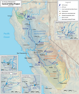
The Central Valley Project (CVP) is a federal water management project in the U.S. state of California under the supervision of the United States Bureau of Reclamation (USBR). It was devised in 1933 in order to provide irrigation and municipal water to much of California's Central Valley—by regulating and storing water in reservoirs in the northern half of the state, and transporting it to the water-poor San Joaquin Valley and its surroundings by means of a series of canals, aqueducts and pump plants, some shared with the California State Water Project (SWP). Many CVP water users are represented by the Central Valley Project Water Association.

The Catawba River originates in Western North Carolina and the name of the river changes to the Wateree River in South Carolina. The river is approximately 220 miles (350 km) long. It rises in the Appalachian Mountains and drains into the Piedmont, where it has been impounded through a series of reservoirs for flood control and generation of hydroelectricity. The river is named after the Catawba tribe of Native Americans. In their Siouan language, they identified as the Kawahcatawbas, "the people of the river".
The Simón Bolívar Hydroelectric Plant, also Guri Dam, is a concrete gravity and embankment dam in Bolívar State, Venezuela on the Caroni River built from 1963 to 1969. It is 7,426 metres long and 162 m high. It impounds the large Guri Reservoir with a surface area of 4,250 square kilometres (1,641 sq mi).

Lake Allatoona is a U.S. Army Corps of Engineers reservoir on the Etowah River in northwestern part of the State of Georgia, in the countryside. This reservoir is mostly in southeastern Bartow County and southwestern Cherokee County. A small portion is located in Cobb County near Acworth. Cartersville is the nearest city to Allatoona Dam. Also, Red Top Mountain State Park is located on its shores, on the peninsula between the two arms of the lake. Most of the north side of the lake remains protected from land development because of its isolated location, mostly blocked by the lake.

New Melones Dam is an earth and rock filled embankment dam on the Stanislaus River, about 5 miles (8.0 km) west of Jamestown, California, United States, on the border of Calaveras County and Tuolumne County. The water impounded by the 625-foot (191 m)-tall dam forms New Melones Lake, California's fourth largest reservoir, in the foothills of the Sierra Nevada east of the San Joaquin Valley. The dam serves mainly for irrigation water supply, and also provides hydropower generation, flood control, and recreation benefits.

The Stanislaus River is a tributary of the San Joaquin River in north-central California in the United States. The main stem of the river is 96 miles (154 km) long, and measured to its furthest headwaters it is about 150 miles (240 km) long. Originating as three forks in the high Sierra Nevada, the river flows generally southwest through the agricultural San Joaquin Valley to join the San Joaquin south of Manteca, draining parts of five California counties. The Stanislaus is known for its swift rapids and scenic canyons in the upper reaches, and is heavily used for irrigation, hydroelectricity and domestic water supply.

The Yuba River is a tributary of the Feather River in the Sierra Nevada and eastern Sacramento Valley, in the U.S. state of California. The main stem of the river is about 40 miles (64 km) long, and its headwaters are split into three major forks. The Yuba River proper is formed at the confluence of the North Yuba and Middle Yuba Rivers, with the South Yuba joining a short distance downstream. Measured to the head of the North Yuba River, the Yuba River is just over 100 miles (160 km) long.

Hartwell Dam is a concrete and embankment dam located on the Savannah River at the border of South Carolina and Georgia, creating Lake Hartwell. The dam was built by the U.S. Army Corps of Engineers between 1955 and 1962 for the purposes of flood control, hydropower and navigation. The concrete and earthen structure spans 15,840 feet (4,828 m). The concrete section is 1,900 feet (579 m) long and rises 204 feet (62 m) above the riverbed at its apex. The Hartwell Dam currently produces 468 million KWh of electricity annually, has prevented over $40 million in flood damage since completion and also provides recreation, water quality, water supply, along with fish and wildlife management.

The Kinzua Dam, on the Allegheny River in Warren County, Pennsylvania, is one of the largest dams in the United States east of the Mississippi River. It is located within the Allegheny National Forest.
Folsom Lake is a reservoir on the American River in the Sierra Nevada foothills of California, United States.

Douglas Dam is a hydroelectric dam on the French Broad River in Sevier County, Tennessee, in the southeastern United States. The dam is operated by the Tennessee Valley Authority (TVA), which built the dam in record time in the early 1940s to meet emergency energy demands at the height of World War II. Douglas Dam is a straight reinforced concrete gravity-type dam 1705 feet long and 202 feet high, impounding the 28,420-acre (11,500 ha) Douglas Lake. The dam was named for Douglas Bluff, a cliff overlooking the dam site prior to construction.

Auburn Dam was a proposed concrete arch dam on the North Fork of the American River east of the town of Auburn, California in the United States, on the border of Placer and El Dorado Counties. Slated to be completed in the 1970s by the U.S. Bureau of Reclamation, it would have been the tallest concrete dam in California and one of the tallest in the United States, at a height of 680 feet (210 m) and storing 2,300,000 acre feet (2.8 km3) of water. Straddling a gorge downstream of the confluence of the North and Middle Forks of the American River and upstream of Folsom Lake, it would have regulated water flow and provided flood control in the American River basin as part of Reclamation's immense Central Valley Project.

New Exchequer Dam is a concrete–faced, rock-fill dam on the Merced River in central California in the United States. It forms Lake McClure, which impounds the river for irrigation and hydroelectric power production and has a capacity of more than 1,000,000 acre feet (1.2 km3). The Merced Irrigation District (MID) operates the dam and was also responsible for its construction.

New Don Pedro Dam, often known simply as Don Pedro Dam, is an earthen embankment dam across the Tuolumne River, about 2 miles (3.2 km) northeast of La Grange, in Tuolumne County, California. The dam was completed in 1971, after four years of construction, to replace the 1924 concrete-arch Don Pedro Dam.
Jackson Meadows Dam is a dam in Nevada County, California.

Throughout history, California has experienced many droughts, such as 1841, 1864, 1924, 1928–1935, 1947–1950, 1959–1960, 1976–1977, 2006–2010, and 2011–2017. As the most populous state in the United States and a major agricultural producer, drought in California can have a severe economic as well as environmental impact. Drought may be due solely to, or found in combination with, weather conditions; economic or political actions; or population and farming.

The 2017 California floods were a series of floods that affected parts of California in the first half of 2017. Northern California saw its wettest winter in almost a century, breaking the previous record set in the winter of 1982–83. Flooding related to the same storm systems also impacted parts of western Nevada and southern Oregon. Damage to California roads and highways alone was estimated at over $1.05 billion.


