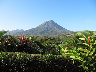
Arenal Volcano is an dormant andesitic stratovolcano in north-western Costa Rica around 90 km northwest of San José, in the province of Alajuela, canton of San Carlos, and district of La Fortuna. The Arenal volcano measures at least 1,633 metres (5,358 ft) high. It is conically shaped with a crater 140 metres (460 ft) in diameter. Geologically, Arenal is considered a young volcano and it is estimated to be less than 7,500 years old. It is also known as "Pan de Azúcar", "Canaste", "Volcan Costa Rica", "Volcan Río Frío" or "Guatusos Peak".

Bull Sluice Lake is created by Morgan Falls Dam, a small hydroelectric dam located along the Chattahoochee River at the northern end of Sandy Springs, Georgia, and crossing the river westwards into eastern Cobb County in north metro Atlanta. Originally constructed in 1904 by Georgia Power to provide electricity for Atlanta's streetcars, it now provides enough power for about 4,400 homes. It was named for then recently deceased Georgia Power president S. Morgan Smith's mother whose maiden name was Morgan. At the time it was by far the largest hydroelectric plant in the state. In 1924 it was rebuilt as a 60 cycle plant with 15,000 kilowatts. In 1957 it was raised to regulate the flow from the larger Buford Dam, 36 miles (58 km) upstream, in order to give Atlanta water during the hours it was needed most. It is 896 feet (273 m) long, and 56 feet (17 m) tall. The dam's license from the Federal Energy Regulatory Commission (FERC) was issued in May 2008, and expires in February 2039 which authorizes a capacity of 16,800 kW.

An underground power station is a type of hydroelectric power station constructed by excavating the major components from rock, rather than the more common surface-based construction methods.

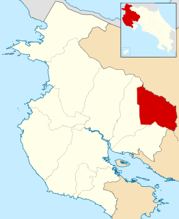
San Carlos is the 10th canton in the province of Alajuela in Costa Rica. The canton covers an area of 3,347.98 square kilometres (1,292.66 sq mi), making it the largest canton in the country. It has a population of 178,460. ranking it fifth.

Carters Dam is an earthen embankment dam located south of Chatsworth in Murray County and west of Ellijay in the U.S. state of Georgia. The dam is 445 feet (136 m) tall and is situated 26.8 miles (43.1 km) above the mouth of the Coosawattee River. The drainage area is 376 square miles (970 km2).
Arenal Volcano National Park is a Costa Rican national park in the central part of the country, forming the Arenal Tilaran Conservation Area. The park encompasses the Arenal Volcano, which "was" the most active in the country, which had previously been believed to be dormant until a major eruption in 1968. It neighbors Lake Arenal, which is the site of the country's largest hydroelectricity project, the Lake Arenal Dam.
Tilarán is the eighth canton in the province of Guanacaste in Costa Rica. The canton covers an area of 638.39 km², and has a population of 20,708. Its capital city is also called Tilarán.

Tabacón is a hot springs resort in the Alajuela Province of Costa Rica, located at the northern base of Arenal Volcano between Lake Arenal and the town of La Fortuna. The geothermal springs are heated naturally by the volcano.
The Oak Grove Hydroelectric Project is a 44 megawatt hydroelectric plant operated by Portland General Electric (PGE) on the Oak Grove Fork Clackamas River. Water for this project is held by three lakes, built between 1923 and 1956. The dam creates the impoundment Lake Harriet.
Arenal River is a river of Costa Rica that is a tributary of the San Carlos River. Its upper part is dammed by the Presa Sangregado Dam to form the Lake Arenal.
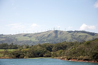
Tejona is a village in the Guanacaste Province, Costa Rica. It is located on Lake Arenal and has a hydroelectric power station. Hotel Tilawa and skateboarding park as well as the Tilawa Viento Surf Center and Arenal Botanical Gardens are located nearby. Some 100 wind turbines, standing at 120 ft (35m) are located southwest of the village on the hills and supply electricity to the national grid. The wind farm is the largest in Central America with an annual production of up to 70MW. Electricity is sold to the Instituto Costarricense de Electricidad.
Costa Rica is divided into three major drainage basins encompassing 34 watersheds with numerous rivers and tributaries, one major lake used for hydroelectric generation, and two major aquifers that serve to store 90% of the municipal, industrial, and agricultural water supply needs of Costa Rica. Agriculture is the largest water user demanding around 53% of total supplies while the sector contributes 6.5% to the Costa Rica GDP. About a fifth of land under cultivation is being irrigated by surface water. Hydroelectric power generation makes up a significant portion of electricity usage in Costa Rica and much of this comes from the Arenal dam.
Lake Spaulding Dam is a dam in Nevada County, California.

Wyman Dam is a hydroelectric dam in Somerset County, Maine.

The Upper North Fork Feather River Project is a hydroelectric scheme in the Sierra Nevada of California, within Lassen and Plumas Counties. The project consists of three dams, five power plants, and multiple conduits and tunnels in the headwaters of the North Fork Feather River, a major tributary of the Feather—Sacramento River systems. The total installed capacity is 362.3 megawatts (MW), producing an annual average of 1,171.9 gigawatt hours (GWh). The project is also contracted for the delivery of irrigation water between March 31 and October 31 of each year. The project is owned and operated by Pacific Gas and Electric.
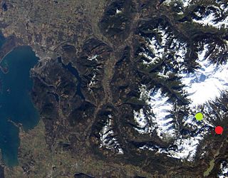
The Koma Kulshan Project is a 13.3 MW run-of-the-river hydroelectric generation facility on the slopes of Mount Baker, a stratovolcano in Washington state's North Cascades. The project commenced commercial operation in October 1990, and is owned by a Covanta Energy–Atlantic Power joint venture. It supplies Puget Sound Energy via a Power Supply Agreement (PSA) contract. Its single turbine is a Pelton wheel supplied by Sulzer Escher Wyss.
Renewable energy in Costa Rica supplied about 98.1% of the electrical energy output for the entire nation in 2016. Fossil fuel energy consumption in Costa Rica was 49.48 as of 2014, with demand for oil increasing in recent years. In 2014, 99% of its electrical energy was derived from renewable energy sources, about 80% of which from hydroelectric power. For the first 75 days of 2015, 100% of its electrical energy was derived from renewable energy sources and in mid 2016 that feat was accomplished for 110 consecutive days despite suboptimal weather conditions. As a country, Costa Rica has a geographic advantage over others in that its high concentration per capita of rivers, dams, and volcanoes allows for a high renewable energy output. In addition, Costa Rica is the fourth highest nation in terms of rainfall per capita: it receives an average of 2,926mm of precipitation per year. As a smaller nation with a population of only 5 million and no major industry, the need for strong energy infrastructure is less than for larger countries of higher population density. The 1948 elimination of the military of Costa Rica freed up millions of dollars from the government defense budget which are now invested in social programs and renewable energy generation. As president of Costa Rica in 1948, José Figueres announced that the nation's former military budget would be refocused specifically in healthcare, education, and environmental protection.
Laguna Poco Sol is a volcanic lake in Costa Rica, in the Cordillera de Tilarán.


