The Staffordshire and Worcestershire Canal is a navigable narrow canal in Staffordshire and Worcestershire in the English Midlands. It is 46 miles (74 km) long, linking the River Severn at Stourport in Worcestershire with the Trent and Mersey Canal at Haywood Junction by Great Haywood.

The Stour(, rhymes with "flour") is a river flowing through the counties of Worcestershire, the West Midlands and Staffordshire in the West Midlands region of England. The Stour is a major tributary of the River Severn, and it is about 25 miles (40 km) in length. It has played a considerable part in the economic history of the region.

South Staffordshire is a local government district in Staffordshire, England. The district lies to the north and west of the West Midlands county, bordering Shropshire to the west and Worcestershire to the south. It contains notable settlements such as Codsall, Cheslyn Hay, Great Wyrley, Penkridge, Brewood, Coven, Essington, Huntington, Weston-under-Lizard, Bilbrook, Wombourne, Himley, Perton and Featherstone. Codsall is the main administrative centre of South Staffordshire District. Many of the villages form both commuter and residential areas for the nearby towns of Cannock, Stafford and Telford, as well as the wider West Midlands County.

Ashwood is a small area of Staffordshire, England.

Kinver Edge is a high heath and woodland escarpment just west of Kinver, about four miles west of Stourbridge, and four miles north of Kidderminster, and is on the border between Worcestershire and Staffordshire, England. It is now owned by the National Trust.
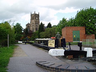
Kinver is a large village in the District of South Staffordshire in Staffordshire, England. It is in the far south-west of the county, at the end of the narrow finger of land surrounded by the counties of Shropshire, Worcestershire and the West Midlands. The nearest towns are Stourbridge, West Midlands, Kidderminster in Worcestershire and Bridgnorth, Shropshire. The Staffordshire and Worcestershire Canal passes through, running close to the course of the meandering River Stour. According to the 2011 census Kinver ward had a population of 7,225.

The Staffordshire Way is a long-distance walk in Staffordshire, England. The path links with the Cheshire Gritstone Trail, the Heart of England Way and the North Worcestershire Path.
Kingswinford Rural District was a rural district in Staffordshire, England from 1894 to 1934. It was created by the Local Government Act 1894, and originally consisted of the two parishes of Amblecote and Kingswinford. Amblecote became a separate urban district in 1898, leaving Kingswinford the only parish in the district.
Philip Foley was the youngest of the three surviving sons of the British ironmaster Thomas Foley. His father transferred all his ironworks in the Midlands to him in 1668 and 1669 for £60,000. He also settled an estate at Prestwood near Stourbridge on him on his marriage, to which Philip added the manor of Kinver.
Stourton is a hamlet in Staffordshire, England a few miles to the northwest of Stourbridge. There is a fair amount of dispute over the pronunciation, being pronounced 'stower-ton', 'stir-ton' or 'store-ton' by different people from the area. The nearest sizeable villages are Wollaston and Kinver, the nearest hamlets are Prestwood and Dunsley. It lies on the River Stour. The Staffordshire and Worcestershire Canal and Stourbridge Canal meet at Stourton Junction, which places Stourton on the Stourport Ring, a navigable waterway popular with narrowboat holidaymakers.
John Hodgetts Hodgetts-Foley, born John Hodgetts Foley, of Prestwood House in Staffordshire was a British MP.
Henry John Wentworth Hodgetts-Foley of Prestwood House, then in Kingswinford parish was a British MP.

The Kinver Light Railway operated a passenger and freight tramway service between Amblecote and Kinver, in South Staffordshire, between 1901 and 1930.
Sir Thomas Whorwood was a Staffordshire landowner, Member of the English Parliament and High Sheriff of Staffordshire. He became notorious for his involvement in election fraud.
Prestwood is a hamlet now in the parish of Kinver, but in the Kingswinford until the creation of Brierley Hill Urban District in the 1930s.
Dunsley is a hamlet in Kinver, Staffordshire, England.
Kinver Forest was a Royal Forest, mainly in Staffordshire.
Kinver Edge Hillfort, is a univallate Iron Age hillfort with a massive rampart and outer ditch along the south-west and south-east sides, with natural defences on the remaining sides. The fort is located at the northern end of Kinver Edge, in the civil parish of Kinver, Staffordshire.
Kinver is a civil parish in the district of South Staffordshire, Staffordshire, England. It contains 54 listed buildings that are recorded in the National Heritage List for England. Of these, one is listed at Grade I, the highest of the three grades, one is at Grade II*, the middle grade, and the others are at Grade II, the lowest grade. The parish contains the village of Kinver, the smaller settlement of Stourton, and the surrounding area. The Stourbridge Canal joins the Staffordshire and Worcestershire Canal in the parish, and listed buildings associated with these canals include locks, a toll house, a bridge, and canal workers' cottages. Most of the other listed buildings are houses and associated structures, cottages, shop, farmhouses and farm buildings, the earliest of which are timber framed or have a timber-framed core. The other listed buildings include a church, former schools, public houses, a former windmill, a malthouse, lodges, a milepost, a war memorial, and a telephone kiosk.
Sir Ferdinando Sutton (1588-1621) was an English aristocrat.