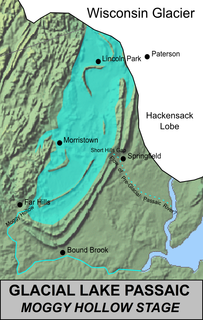
Lake Passaic was a prehistoric proglacial lake that existed in northern New Jersey in the United States at the end of the last ice age approximately 19,000-14,000 years ago. The lake was formed of waters released by the retreating Wisconsin Glacier, which had pushed large quantities of earth and rock ahead of its advance, blocking the previous natural drainage of the ancestral Passaic River through a gap in the central Watchung Mountains. The lake persisted for several thousand years as melting ice and eroding moraine dams slowly drained the former lake basin. The effect of the lake’s creation permanently altered the course of the Passaic River, forcing it to take a circuitous route through the northern Watchung Mountains before spilling out into the lower piedmont.

The Second River, or Watsessing River, in the state of New Jersey in the United States, is the second main tributary of the Passaic River encountered while travelling upstream from its mouth at Newark Bay.

The Rockaway River is a tributary of the Passaic River, approximately 35 mi (56 km) long, in northern New Jersey in the United States. The upper course of the river flows through a wooded mountainous valley, whereas the lower course flows through the populated New Jersey suburbs and former industrial area west of New York City. It drains an area of approximately 130 sq mi (340 km²).

Conrail's Passaic and Harsimus Line serves freight in northeastern New Jersey, as an alternate to the mainly passenger Northeast Corridor. It takes trains from the Northeast Corridor and Lehigh Line near Newark Liberty International Airport northeast and east into Jersey City, New Jersey, serving as part of CSX's main corridor from upstate New York to the rest of the east coast.
The Saddle River flows south through much of Bergen County, New Jersey. The river runs through densely populated suburban areas for much of its course. The river takes its name from the river near Saddell in Argyll and Bute in Scotland.
Stevenson Brook is a tributary of the Passaic River in Hawthorne, Passaic County, New Jersey in the United States.
Little Diamond Brook is a tributary of the Passaic River which flows south through a section of Bergen County in New Jersey. Heading up the approximately two mile long brook from the Passaic River, one encounters the towns of Fair Lawn and Glen Rock.

The Skylands Region is a region and marketing area of the State of New Jersey located in the Northern and Central part of the state. It is one of six tourism regions established by the New Jersey State Department of Tourism, the others being the Gateway Region, Greater Atlantic City Region, the Southern Shore Region, the Delaware River Region and the Shore Region. The area officially encompasses Hunterdon, Morris, Somerset, Sussex and Warren counties; the northwestern part of the Passaic County fits in with the Skylands Region, but it is part of the Gateway Region and not the Skylands Region. One could also say that the western most part of Bergen is also part of the skylands. The area features uplifted land, rolling hills and mountains characteristic of North Jersey. The region contains 60,000 acres of state parkland, and a diverse geography filled with lakes, rivers and picturesque hills.
Salt Brook is a tributary of the Passaic River in Union County, New Jersey in the United States.
Loantaka Brook is a tributary of the Passaic River in New Jersey in the United States.
The Old Great Falls Historic District is an area of Paterson, New Jersey between South Paterson and Hillcrest, Paterson. The area is a thin strip of neighborhoods and parklands around the Passaic River and Garret Mountain. This section of Paterson has two National Natural Landmarks, Garret Mountain and Great Falls on the Passaic. It is the location of the highest point in Paterson. It is home to Lambert Castle and Alexander Hamilton's Society for the Establishment of Useful Manufactures (S.U.M.), which used the force of Great Falls to power the mills along the Passaic in the Dublin section. The neighborhood is also home to part of Garret Mountain Reservation and Overlook Park around the Grand Street Reservoir. The neighborhood is bounded by the border with Hillcrest by the Passaic River, by the Woodland Park border, the South Paterson border along Valley Road and Route 19. It is separated from Downtown Paterson to the north by Route 19, Oliver Street and Spruce Street.
Hillcrest is a large mostly residential, middle class enclave in Paterson, New Jersey. It is located to the west of the Downtown Paterson. Its borders' limits are Preakness Avenue to the northeast, the Borough of Totowa, New Jersey border to the south and west and the Passaic River to the southeast. It is home to West Side Park, and Emerald Experience Way. Hillcrest is one of Paterson's most desirable neighborhoods. The Hillcrest section of Paterson is located in the city's 2nd Ward. It is mostly residential with a compact commercial area along Union Avenue north of Oldhams Brook.

Lord Stirling Park is a 925/950 acre park operated by the Somerset County Park Commission and located in Basking Ridge, New Jersey, and separated from the Great Swamp National Wildlife Refuge by the Passaic River. The park displays a diverse ecosystem in floodplains of the upper Passaic River and its contributors and contains swamps, fields, forests, brooks, marshes, and meadows.
The Lenape Trail is a trail connecting Newark, New Jersey with Roseland, New Jersey. It was established in 1982. It is the fifth longest trail in the state behind the Delaware and Raritan Canal Trail, the Appalachian Trail, the completed section of the Highlands Trail in the state and the Batona Trail. The Lenape trail traverses Newark and its suburbs, as well as the Watchung Mountains and Passaic Meadows. Because of the steepness of the Watchung Mountains and the flood-prone nature of the Passaic Meadows, the former basin of Glacial Lake Passaic, these areas have remained much less developed than the rest of the northeastern part of the state. This trail therefore offers hikers an opportunity to see cultural and historical sites of an urban trail, as well as large natural and undeveloped areas. The trail's proximity to New York City and the various ridges it traverses, including Forest Hill, Orange Mountain, and Second Watchung Mountain, offer many views of the skyline. The Lenape Trail forms a segment of the Liberty-Water Gap Trail and incorporates the West Essex Trail, the Lenape Trail's only rail-to-trail section. The Lenape Trail also connects with Morris County's Patriots Path trail system on its western terminus.
Great Piece Meadows is a 7,100-acre (29 km2) fresh water swamp located in the towns of Lincoln Park, Montville, and Fairfield in New Jersey. The wooded swamp is mostly inside the bow of the Passaic River which floods during the year from heavy rain or heavy snow melt.

Great Ditch is a drainage ditch that drains areas of the Pigeon Swamp State Park in New Jersey in the United States.

Black Brook is a tributary of the Passaic River that flows through the Great Swamp National Wildlife Refuge in Morris County, New Jersey, in the United States. Black Brook rises at the north east base of Long Hill, Chatham Township, Morris County, flows westerly along the hill, by a course of 7 or 8 miles to its recipient in Morris Township, New Jersey. Due to the chemical fertilizer usage in nearby areas, Black Brook has the second worst water quality after Loantaka Brook.

Passaic River Parkway, often called Passaic River Park, is a linear park along the banks of the Passaic River in Union County, New Jersey. It is one of the three "emerald necklaces" in the Union County Park System, the others being Rahway River Parkway and Elizabeth River Parkway.