Great Swamp National Wildlife Refuge

Last updated

Great Swamp National Wildlife Refuge
IUCN category IV (habitat/species management area)
Image-Great Swamp National Wildlife Refuge New Jersey03.jpg
Great Swamp National Wildlife Refuge in New Jersey in March 2008
Location map of Morris County, New Jersey.svg
Red pog.svg
Map of Morris County with State of New Jersey inset and Great Swamp highlighted
Location Morris County, New Jersey, U.S.
Nearest city Morristown, New Jersey
Coordinates 40°42′30″N74°28′00″W / 40.70833°N 74.46667°W / 40.70833; -74.46667
Area7,800 acres (32 km2)
Established1960
Governing body U.S. Fish and Wildlife Service
Website Great Swamp National Wildlife Refuge
DesignatedMay 1966

The Great Swamp National Wildlife Refuge is located in Morris County, New Jersey. Established in 1960, it is among what has grown to be more than 550 refuges in the United States National Wildlife Refuge System.

Contents

The first part of the Great Swamp that was assembled and donated for perpetual preservation by the park service of the federal government was declared a National Natural Landmark in May 1966. [1] More land has been added several times. Its eastern half (3,660 acres (14.8 km2)) was designated as a wilderness by Congress in 1968, [2] making it the first wilderness area within the Fish and Wildlife Service.

Since about 1966, it has been managed by the Morris County Park Commission. [3]

Administration

The refuge is managed by the United States Fish and Wildlife Service, an agency within the United States Department of the Interior. Refuge lands lie within the townships of Chatham, Harding, and Long Hill.

History

Geologic

The Great Swamp is the remnant of the bottom of the once-mighty Glacial Lake Passaic that approximately 15,000 to 11,000 years ago stretched across 30 by 10 miles (48 by 16 km) in what is presently northern New Jersey. The lake was formed by the melting waters of the retreating Wisconsin Glacier at the end of the last ice age. The glacier had pushed a moraine ahead of its advance, a rubble of soil and rocks that plugged the existing outlet for the waters that drained into the area of the watershed. As the retreating glacier melted, the waters rose to create the lake before a new outlet began to allow the water to exit at a much higher elevation. [2]

Hydrographic image of a typical drainage basin, called a watershed in the United States Hydrographic basin.svg
Hydrographic image of a typical drainage basin, called a watershed in the United States

The plug altered the course of the Passaic River, which had drained a swamp that predated the lake. A range of mountains to the west of Morristown formed the western boundary of the new lake and the most easterly line of the Watchung Mountains became the eastern boundary. The tops of some of the Watchung range became islands in the great lake. Water that had vented through the Watchung range, or to its south, found a new path that altered the old drainage paths. When the plug collapsed, the river still was forced to travel north through the range before finding a new outlet near present-day Paterson where it could manage the eastern turn toward the sea.

Early settlers

Some ten thousand years ago, Amerindians arrived in the area and established settlements shortly after the retreat of the glacier, hunting, fishing, and farming. In 1614, Dutch colonists claimed part of the area as New Netherlands and they traded with the natives. Later, British settlers came, establishing dominion over what they called the Province of New Jersey.

The refuge includes about one-quarter of the Great Swamp 55-square-mile (140 km2) watershed that gives rise to the Passaic River. The watershed touches ten modern communities, many of which were settled by European colonists long before the American Revolution.

Wildlife Refuge formation

Great Swamp National Wildlife Refuge, December Great Swamp National Wildlife Refuge, December.jpg
Great Swamp National Wildlife Refuge, December

The land that would become the Great Swamp National Wildlife Refuge was established by an Act of Congress on November 3, 1960, after a multi-year legal battle that pitted local residents against Port Authority of New York and New Jersey officials wishing to turn the Great Swamp into a major regional airport to supplement Newark Airport's ability to accommodate large jet aircraft. [4]

The Jersey Jetport Site Association was the first to form in opposition. Their efforts to prevent the development of an airport in the swamp became public knowledge on December 3, 1959, when four of its members (Kafi Benz, Joan Kelly, Esty Weiss, and Betty White) were expelled from a meeting at the Essex House in Newark that had been organized to generate support for its construction. [5] The JJSA activity was followed closely by an influential sister organization when (because of connections with Marcellus Hartley Dodge, Sr., a major donor to and participant in JJSA) the North American Wildlife Foundation established its specially designated, Great Swamp Committee, in 1960. [6] Between the two organizations and, in less than a year, enough property in the core of the swamp was quickly purchased, assembled, and donated to the federal government to qualify for perpetual protection as a National Wildlife Refuge. [7] As the representative from Arizona, Stewart Udall immediately championed the efforts of these residents, whom he described as having mounted the greatest effort ever made by residents in America to protect a natural habitat, and later, on May 29, 1964, as the Secretary of the Interior, he oversaw its dedication as a refuge. The initial donation was 2,600 acres (11 km2), which assured its protection as a refuge and the acquisition of additional lands continued. In 1960, Representative Peter Frelinghuysen, Jr., whose estate was in the area targeted for development also joined the effort. [8] [9] [10]

Description

Map of the Great Swamp National Wildlife Refuge Great swamp map.png
Map of the Great Swamp National Wildlife Refuge

By the end of 2010, the extent of the Great Swamp National Wildlife Refuge had grown to nearly 7,800 acres (32 km2) of varied habitats. It lies within the Northeastern coastal forests ecoregion. [11] When the remainder of the area donated was dedicated on September 9, 1968, it was the first refuge to receive wilderness designation. [12]

The Great Swamp is a migration-resting and feeding area or a permanent habitat for more than 244 species of birds. The major routes of birds migrating along the eastern portion of the United States follow the corridor that includes the Great Swamp as an important stopping place for rest and nutrition.

Many species of birds reside permanently in the watershed. Deer, fish, fox, frogs, muskrat, raccoons, snakes, turtles, as well as many insects and a wide variety of wildflowers and plants call the refuge "home". Some of the animals hunted by the prehistoric native inhabitants and colonists, such as bear and beaver, are encountered occasionally. Its role in draining the region and absorbing flood water for gradual release can be critical during extreme weather conditions. The refuge also plays an important role in improving water quality by acting as a natural ecological filter trapping sediments and contaminants.

Numerous nonprofit organizations have arisen from the communities within the Great Swamp watershed and work closely in partnership with the refuge. The Great Swamp Watershed Association, founded in 1981, works to protect the entire 55-square-mile (140 km2) watershed that surrounds the swamp. [13] Within the Great Swamp there also is a nonprofit bird-rehabilitation center founded in 1977, called The Raptor Trust, mainly specializing in birds of prey, such as eagles, hawks, and owls. Lord Stirling Park is part of the Somerset County Park System. The park is entered from the community of Stirling that is named after a military officer of the American Revolution who lived in the community, William Alexander. The park is located immediately adjacent to the southwestern boundary of the refuge on the west side of the Passaic River. The park offers excellent hiking facilities that include trails, boardwalks, observation blinds, and naturalist exhibits displayed in its park office that are related to the swamp and its wildlife.

See also

Related Research Articles

<span class="mw-page-title-main">Chatham Borough, New Jersey</span> A borough in Morris County, New Jersey, US

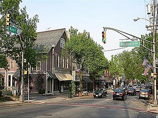
Chatham Borough is a suburban borough in Morris County, in the U.S. state of New Jersey. As of the 2020 United States census, the borough's population was 9,212, an increase of 250 (+2.8%) from the 2010 census count of 8,962, which in turn reflected an increase of 502 (+5.9%) from the 8,460 counted in the 2000 census.

<span class="mw-page-title-main">Long Hill Township, New Jersey</span> Township in Morris County, New Jersey, US

Long Hill Township is a township in Morris County, in the U.S. state of New Jersey. As of the 2020 United States census, the township's population was 8,629, a decrease of 73 (−0.8%) from the 2010 census count of 8,702, which in turn reflected a decline of 75 (−0.9%) from the 8,777 counted in the 2000 census.

<span class="mw-page-title-main">Jamaica Bay</span> Bay on the southern side of Long Island, New York

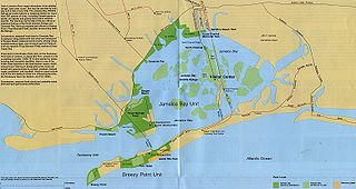
Jamaica Bay is an estuary on the southern portion of the western tip of Long Island, in the U.S. state of New York. The estuary is partially man-made, and partially natural. The bay connects with Lower New York Bay to the west, through Rockaway Inlet, and is the westernmost of the coastal lagoons on the south shore of Long Island. Politically, it is primarily divided between the boroughs of Brooklyn and Queens in New York City, with a small part touching Nassau County.

<span class="mw-page-title-main">Passaic River</span> River in New Jersey, United States

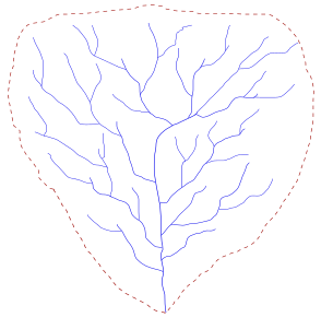
The Passaic River is a river, approximately 80 miles (130 km) long, in Northern New Jersey. The river in its upper course flows in a highly circuitous route, meandering through the swamp lowlands between the ridge hills of rural and suburban northern New Jersey, called the Great Swamp, draining much of the northern portion of the state through its tributaries.

<span class="mw-page-title-main">Lake Passaic</span> Former proglacial lake in New Jersey, U.S.

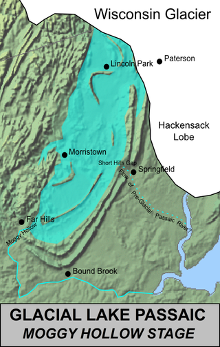
Lake Passaic was a prehistoric proglacial lake that existed in northern New Jersey in the United States at the end of the last ice age approximately 19,000–14,000 years ago. The lake was formed of waters released by the retreating Wisconsin Glacier, which had pushed large quantities of earth and rock ahead of its advance, blocking the previous natural drainage of the ancestral Passaic River through a gap in the central Watchung Mountains. The lake persisted for several thousand years as melting ice and eroding moraine dams slowly drained the former lake basin. The effect of the lake's creation permanently altered the course of the Passaic River, forcing it to take a circuitous route through the northern Watchung Mountains before spilling out into the lower piedmont.

<span class="mw-page-title-main">Watchung Mountains</span> Group of three long low ridges in northern New Jersey

The Watchung Mountains are a group of three long low ridges of volcanic origin, between 400 and 500 feet high, lying parallel to each other in northern New Jersey in the United States. The name is derived from the American Native Lenape name for them, Wach Unks. In the 18th century, the Euro-American settlers also called them the Blue Mountains or Blue Hills. The Watchung Mountains are known for their numerous scenic vistas overlooking the skylines of New York City and Newark, New Jersey, as well as their isolated ecosystems containing rare plants, endangered wildlife, rich minerals, and globally imperiled trap rock glade communities. The ridges traditionally contained the westward spread of urbanization, forming a significant geologic barrier beyond the piedmont west of the Hudson River; the town of Newark, for example, once included lands from the Hudson to the base of the mountains. Later treaties moved the boundary to the top of the mountain, to include the springs.

<span class="mw-page-title-main">Alaska Peninsula National Wildlife Refuge</span> United States National Wildlife Refuge in southwestern Alaska

The Alaska Peninsula National Wildlife Refuge is a United States National Wildlife Refuge in southwestern Alaska whose use is regulated as an ecological-protection measure. It stretches along the southern coast of the Alaska Peninsula, between the Becharof National Wildlife Refuge on its east and the end of the peninsula at False Pass in the west. In between, however, it is broken into sections by lands of the Aniakchak National Monument and Izembek National Wildlife Refuge. The refuge is administered from offices in King Salmon, Alaska and was established to conserve Alaska Peninsula brown bears, caribou, moose, marine mammals, shorebirds, other migratory birds and fish, and to comply with treaty obligations.

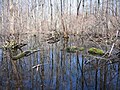
Hatfield Swamp is a fresh water wetland area in the U.S. state of New Jersey, forming what might be considered the "second bank" of the Passaic River between Morris and Essex counties.

<span class="mw-page-title-main">Great Dismal Swamp</span> Swamp in Virginia and North Carolina, US

The Great Dismal Swamp is a large swamp in the Coastal Plain Region of southeastern Virginia and northeastern North Carolina, between Norfolk, Virginia, and Elizabeth City, North Carolina. It is located in parts of the southern Virginia independent cities of Chesapeake and Suffolk and northern North Carolina counties of Gates, Pasquotank, and Camden. Some estimates place the original size of the swamp at over one million acres (4,000 km2). As of 2022 the size of the Great Dismal Swamp is around 750 square miles.

<span class="mw-page-title-main">Great Dismal Swamp National Wildlife Refuge</span> United States National Wildlife Refuge in Virginia

The Great Dismal Swamp National Wildlife Refuge was created in 1974 to help protect and preserve a portion of the Great Dismal Swamp, a marshy region on the Coastal Plain of southeastern Virginia and northeastern North Carolina between Norfolk, Virginia, and Elizabeth City, North Carolina in the United States. It is located in parts of the independent cities of Chesapeake and Suffolk in Virginia, and the counties of Camden, Gates, and Pasquotank in North Carolina.

<span class="mw-page-title-main">Okefenokee National Wildlife Refuge</span> Nature center in Folkston, Georgia, USA

The Okefenokee National Wildlife Refuge is a 402,000‑acre (1,627 km2) National Wildlife Refuge located in Charlton, Ware, and Clinch Counties of Georgia, and Baker County in Florida, United States. The refuge is administered from offices in Folkston, Georgia. The refuge was established in 1937 to protect a majority of the 438,000 acre (1,772 km2) Okefenokee Swamp. Though often translated as "land of trembling earth", the name "Okefenokee" is likely derived from Hitchiti oki fanôːki "bubbling water".

<span class="mw-page-title-main">Cape May National Wildlife Refuge</span> Wildlife habitat in New Jersey, US

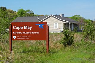
The Cape May National Wildlife Refuge is a protected area on the Cape May Peninsula in Cape May County, New Jersey. It is part of the National Wildlife Refuge System and managed by the United States Fish and Wildlife Service. Established in January 1989 with 90 acres (0.36 km2) acquired from the Nature Conservancy, it has since grown to more than 11,000 acres (45 km2) in size, and plans call for its further expansion to more than 21,200 acres (86 km2). It comprises three distinct and non-contiguous units: the Delaware Bay Division, the Great Cedar Swamp Division and the Two Mile Beach Unit. Located in the Middle Atlantic coastal forests ecoregion, the cape provides habitat for large numbers of migratory birds.

<span class="mw-page-title-main">Horicon Marsh</span> National State Wildlife Area, Dodge and Fond du Lac counties, Wisconsin

Horicon Marsh is a marsh located in northern Dodge and southern Fond du Lac counties of Wisconsin. It is the site of both a national and a state wildlife refuge. The silted-up glacial lake is the largest freshwater cattail marsh in the United States.

<span class="mw-page-title-main">Geography of New Jersey</span> Overview of the geography of New Jersey

New Jersey is a state within the United States of America that lies on the north eastern edge of the North American continent. It shares a land border with the state of New York along the north, ratified by both states after the New York – New Jersey Line War, which is its only straight line border.

Citizens United to Protect the Maurice River and Its Tributaries, Inc., or "CU", is a 501(c)(3) (nonprofit) regional watershed organization. It was founded in 1979 and incorporated in 1986.

<span class="mw-page-title-main">Lord Stirling Park</span> Park in New Jersey, United States

Lord Stirling Park is a 925/950 acre park operated by the Somerset County Park Commission and located in Basking Ridge, New Jersey, and separated from the Great Swamp National Wildlife Refuge by the Passaic River. The park displays a diverse ecosystem in floodplains of the upper Passaic River and its contributors and contains swamps, fields, forests, brooks, marshes, and meadows.

<span class="mw-page-title-main">Ottawa National Wildlife Refuge</span>

Ottawa National Wildlife Refuge is a National Wildlife Refuge of the United States, which is located in the state of Ohio. This refuge was established in 1961, under the Migratory Bird Conservation Act, the purpose of the refuge being created was “… for use as an inviolate sanctuary, or for any other management purpose, for migratory birds.” 16 U.S.C. 715d. This refuge provides ideal habitat for a wide range for migratory birds and waterfowl, along with the native wildlife, and any endangered and threatened species. The property of the refuge was purchased from hunt clubs and farmlands with the Federal Duck Stamps.

<span class="mw-page-title-main">Whittlesey Creek National Wildlife Refuge</span> National Wildlife Refuge and coastal wetlands in Bayfield County, Wisconsin

Whittlesey Creek National Wildlife Refuge is part of a large wetland complex on Lake Superior, near Ashland, Wisconsin. These coastal wetlands are a significant part of the wildlife habitat and aquatic resources of the south shore of Lake Superior.

<span class="mw-page-title-main">Geraldine Rockefeller Dodge</span> American heiress and arts patron (1882–1973)

Ethel Geraldine Rockefeller Dodge was the youngest child of William Avery Rockefeller Jr. and Almira Geraldine (Goodsell) Rockefeller. Giralda Farms was the name given to the New Jersey country estate where the family lived. She was a great patron of the arts and parts of her collection became the object of a lawsuit following her death.

<span class="mw-page-title-main">Passaic River Parkway</span>

Passaic River Parkway, often called Passaic River Park, is a linear park along the banks of the Passaic River in Union County, New Jersey. It is one of the three "emerald necklaces" in the Union County Park System, the others being Rahway River Parkway and Elizabeth River Parkway.

References

  1. "National Natural Landmarks in New Jersey". NPS. February 5, 2004. Retrieved March 8, 2009.
  2. 1 2 "Great Swamp National Wildlife Refuge: History". U.S. Fish and Wildlife Service. Retrieved April 6, 2020.
  3. Senate, United States Congress (1968). Hearings. U.S. Government Printing Office. pp. 40–41.
  4. Plotch, Philip (2023). Mobilizing the Metropolis: How the Port Authority Built New York. University of Michigan Press. pp. 54–69. ISBN   978-0472056132.
  5. St. John, Kate, 55 Years Ago Today: A Victory For Birds , Outside My Window, November 3, 2015
  6. Hamilton, Leonard W., Ph.D., Keynote Address to the Tenth Anniversary Celebration Archived September 7, 2006, at the Wayback Machine , Ten Towns Committee, Sustainable Stewardship, June 24, 2005
  7. GREAT SWAMP IN NEW JERSEY, DONATED TO GOVERNMENT AS WILDLIFE AREA, TO BE DEDICATED (press release) Fish and Wildlife Service. May 25, 1964.
  8. Dean, Clarence (January 14, 1960). "Plan for Airport Argued in New Jersey" (PDF). The New York Times. Retrieved June 5, 2013.
  9. Honig, Milton (December 17, 1961). "Jetport Enemies Say They've Won" (PDF). The New York Times. Retrieved June 5, 2013.
  10. Doig, Jameson W. (2001). Empire on the Hudson: Entrepreneurial Vision and Political Power at the Port of New York Authority . Columbia University Press. pp.  385–6.
  11. Olson, D. M, E. Dinerstein; et al. (2001). "Terrestrial Ecoregions of the World: A New Map of Life on Earth". BioScience . 51 (11): 933–938. doi: 10.1641/0006-3568(2001)051[0933:TEOTWA]2.0.CO;2 .{{cite journal}}: CS1 maint: multiple names: authors list (link)
  12. "Friends of Great Swamp".
  13. "Great Swamp Watershed Association".

PD-icon.svg This article incorporates public domain material from websites or documents of the United States Fish and Wildlife Service .