List of crossings of the Lower Passaic River

Last updated

The NX, Clay Street, and Stickel bridges are seen in this view looking downstream, or south, to Newark Gateway. Nxbascule3.JPG
The NX, Clay Street, and Stickel bridges are seen in this view looking downstream, or south, to Newark Gateway.
Five bridges over the Passaic River at Newark. PassaicRiverNewarkbridges1.tif
Five bridges over the Passaic River at Newark.

The Lower Passaic River in New Jersey is the section of the Passaic River below the Great Falls which flows over the Dundee Dam to the river mouth at Newark Bay in the northeastern part of the state. Its midpoint generally delineates the Essex-Hudson and Passaic-Bergen county lines. Numerous spans, mostly moveable bridges, have been built over of the lower reaches of the river, which is tidally influenced to the dam at about mile point (MP) 17.4 and channelized to about MP 17. Once one of the most heavily used waterways in the Port of New York and New Jersey, it remains partially navigable for commercial marine traffic. While requests have significantly diminished since the mid-late 20th century, the bridge at MP 11.7 and those downstream from it are required by federal regulations to open with advance notice, with the exception of the first at MP 1.8, which is staffed and opens on demand.

Contents

Early fixed crossings included turnpikes, sometimes built as plank roads. Wood, and later, metal bridges were constructed by competing railroads to access railyards, carfloat operations, passenger terminals, and ferries on the Hudson Waterfront. Rail lines led to further industrialization, urbanization-suburbanization, and the construction of vehicular bridges and streetcar lines. The advent of automobile age in the early and mid 20th century saw the building of highway bridges.

The Acquackanonk Bridge was dismantled in 1776 as George Washington retreated from Fort Lee. Another with the same name at the crossing was lost to flooding in 1903. The first railroad swing bridge in the United States was built in 1833. Numerous bridges have been demolished or fallen into disuse, while others have had their swing spans removed, replaced or immobilized. Some have been rebuilt or replaced.

Crossings

MP CrossingImageOpenCarries/CarriedLocale/Connecting NBI CoordinateNotesReference
1.2 PD Draw
(unused-swing span removed)
PD Draw Bridge 20070712.jpg 1869
1912
Newark and New York Railroad (CNJ) Kearny Point &
Newark Ironbound
40°43′22″N74°07′14″W / 40.72279°N 74.12053°W / 40.72279; -74.12053 (PD Draw) Swing span shifted to new alignment [1] [2] [3]
Portway Bridge
(proposed)
Doremus Avenue to Central/Pennsylvania Aves Kearny Point &
Port Newark
alignment undeterminedNJDOT to
Wittpenn Bridge replacement
[4] [5]
1.8 Lincoln Highway Passaic River Bridge Lincoln Highway Passaic River Bridge from southeast (2018).jpg 1941Truck plate.svg
US 1-9.svg
US 1-9 Truck
milepoint 0.67
Lincoln Highway
Kearny Point &
Newark Ironbound
0705151 40°43′57″N74°07′04″W / 40.7324°N 74.1179°W / 40.7324; -74.1179 (Lincoln Highway Passaic River Bridge) East Coast Greenway
Raymond Boulevard
NJRHP
[6] [7] [8] [9] [10]
Newark Plank Road
(removed)
1795 original
1941 last
Lincoln Highway
PS
40°43′58″N74°07′04″W / 40.7327°N 74.1179°W / 40.7327; -74.1179 (Newark Plank Road) Ferry Street
Communipaw Ave
[9]
2.0 Pulaski Skyway Pulaski Skyway full view.jpg 1932US 1-9.svg US 1/9 0901150 (Hudson) [11]

0704150 (Essex) [12]

40°44′06″N74°07′03″W / 40.73495°N 74.11743°W / 40.73495; -74.11743 (Pulaski Skyway) no trucks, bicycles, or peds
NJRHP & NRHP
[6] [7]
2.6 Point-No-Point Bridge 2021-09-19 10 55 06 View southeast down the Passaic River towards the Point-No-Point Bridge and Pulaski Skyway from the Chaplain Washington Bridge for Interstate 95 (New Jersey Turnpike Eastern Spur) along the border of Newark and Kearny in New Jersey.jpg Conrail
Passaic and Harsimus Line (CSX) (NS)
Kearny Meadows &
Newark Ironbound
40°44′30″N74°07′16″W / 40.7416°N 74.1211°W / 40.7416; -74.1211 (Point-No-Point Bridge) PRR [1] [13]
2.7Chaplain Washington Bridge Interstate 95 Bridges 20070712.jpg 1952 NJ Turnpike Eastern Spur
I-95.svg I-95
W107870 40°44′31″N74°07′22″W / 40.74204°N 74.12264°W / 40.74204; -74.12264 (Chaplain Washington Bridge) no bicycles or pedestrians [6] [7] [14] [15]
2.7 Harry Laderman Bridge NewJerseyTurnpikePassaicRiver.jpg 1970 NJ Turnpike Western Spur
I-95.svg I-95
E107880 40°44′31″N74°07′23″W / 40.74196°N 74.12307°W / 40.74196; -74.12307 (Harry Laderman Bridge) no bicycles or pedestrians [6] [7] [14] [16]
4.6 Jackson Street Bridge Jackson Rogers Passaic br jeh.JPG 1903Jackson Street
Frank E. Rodgers Blvd
Harrison &
Newark Ironbound
0700H02 40°44′02″N74°09′19″W / 40.73383°N 74.15527°W / 40.73383; -74.15527 (Jackson Street Bridge) NJRHP [6] [7] [17]
Market Street Bridge (removed)1868
1899
NJRR
PRR
Harrison &
Newark Penn
40°44′09″N74°09′43″W / 40.7358°N 74.1619°W / 40.7358; -74.1619 (Market Street Bridge) Swing span shifted to new alignment [18]
5.0 Dock Bridge
(2 spans)
Dock Bridge - Newark, NJ.jpg 1935 (west)
1937 (east)
Northeast Corridor
Amtrak
Northeast Corridor Line (NJT)
North Jersey Coast Line (NJT)
Raritan Valley Line (NJT)
PATH
40°44′10″N74°09′41″W / 40.7361°N 74.1615°W / 40.7361; -74.1615 (Dock Bridge) PRR & H&M
NJRPH & NRHP
[1]
Centre Street Bridge
(removed)
Centre Street Bridge, Newark, NJ.tif 1834
1911
New Jersey Railroad
PRR
H&M
Route 158
Harrison &
Downtown Newark
Park Place Station
40°44′28″N74°09′51″W / 40.74099°N 74.16404°W / 40.74099; -74.16404 (Centre Street Bridge) Upper level added
Converted from rail to vehicular bridge 1927
5.6 Bridge Street Bridge BridgeStBridgePassaicRiverDtownNewark.JPG 1913Bridge Street & Harrison Avenue
CR 508 jct.svg CR 508
Harrison &
Downtown Newark
0700H03 40°44′43″N74°09′57″W / 40.74515°N 74.16574°W / 40.74515; -74.16574 (Bridge Street Bridge) NJRHP [6] [7] [19]
5.85 Newark Drawbridge Passaic River Morristown Line bridge jeh.jpg 1903 Montclair-Boonton Line (NJT)
Morristown Line (NJT)
Gladstone Branch (NJT)
Harrison & Newark Broad Street Station 40°44′51″N74°09′57″W / 40.74743°N 74.16589°W / 40.74743; -74.16589 (Newark Drawbridge) Morris and Essex Railroad
(DL&W)
[1] [6] [20]
5.9 William A. Stickel Memorial Bridge William Stickel Memorial Bridge from train on adjacent railroad bridge (2010).jpg 1949I-280.svg I-280 Harrison &
Newark
0731161 40°44′53″N74°09′57″W / 40.7480°N 74.1659°W / 40.7480; -74.1659 (William A. Stickel Memorial Bridge) [6] [7] [21]
6.0 Clay Street Bridge Clay Street Bridge Newark jeh.jpg 1908
1976 rehab
Central Avenue
Clay Street
East Newark &
Newark Broadway
0700H01 40°45′04″N74°09′55″W / 40.75103°N 74.16522°W / 40.75103; -74.16522 (Clay Street Bridge) [6] [7] [22]
6.35 NX Bridge (abandoned) Erie-Lackawanna bascule E Newark jeh.jpg 1922 Newark Branch (Erie) Harrison/East Newark &
Newark
40°45′16″N74°09′51″W / 40.7544°N 74.1643°W / 40.7544; -74.1643 (NX Bridge) Fixed open position [1] [23]
8.1 WR Draw
(unused)
WR Draw Passaic River (North Newark-West Arlington).tiff 1897 New York & Greenwood Lake (Erie)
Boonton Line (NJT)
Arlington, Kearny &
North Newark
40°46′36″N74°09′01″W / 40.7768°N 74.1502°W / 40.7768; -74.1502 (WR Draw) Kearny Riverbank Park [1] [24]
Passaic AvenuePassaic Avenue
CR 699 CR 699 jct.svg
Arlington, Kearny 0900029 40°46′36″N74°09′01″W / 40.7768°N 74.1502°W / 40.7768; -74.1502 (WR Draw) branch of Passaic [7] [6]
8.9 Belleville Turnpike Bridge Belleville Turnpike lift bridge SW cloudy jeh.jpg 1790
1841
1914
2002
Ellipse sign 7.svg Route 7 (Belleville Turnpike) Arlington, Kearny &
Belleville
0208150 40°47′11″N74°08′51″W / 40.78647°N 74.14750°W / 40.78647; -74.14750 (Belleville Turnpike Bridge) [6] [7] [25]
10.7 Avondale Bridge KingslandAveBridgePassaicRiver1.tif 1905
1986 rehab
Park Avenue to Kingsland Avenue Nutley &
Lyndhurst
NJ 0700B01
NJ 020032A
40°48′40″N74°08′19″W / 40.81103°N 74.13852°W / 40.81103; -74.13852 (Avondale Bridge) aka DeJessa Memorial Bridge or Park Avenue Bridge [6] [7] [26]
11.7 Lyndhurst Draw Lyndhurst Draw (Passaic River).tiff 1903 Main Line (NJT)
NS
Clifton Delawanna &
Lyndhurst
40°49′14″N74°07′36″W / 40.82069°N 74.12668°W / 40.82069; -74.12668 (Lyndhurst Draw) DL&W & Erie
Boonton Branch
NJRHP
[1] [6] [27]
Route 3 Passaic River Crossing
Dual bridges
2014Ellipse sign 3.svg Route 3
milepoint 4.95
Clifton &
Rutherford/Lyndhurst
1601155
1601164
40°49′23″N74°07′26″W / 40.82296°N 74.12394°W / 40.82296; -74.12394 (Route 3 Passaic River Crossing) NJDOT [6] [7] [28]
11.8Old Route 3 Passaic River Bridge
(demolished)
Old Route 3 Bridge 200707.jpg 1949
demolished 2013
Clifton &
Rutherford
40°49′23″N74°07′26″W / 40.82296°N 74.12394°W / 40.82296; -74.12394 (Old Route 3 Passaic River Bridge) [29]
13.2 Union Avenue Bridge
1896 Bridge UnionAveBridgePassaicRiver.tiff
1896 Bridge
2002 Bridge Union Ave Bridge 20070717-jag9889.jpg
2002 Bridge
1896
2002 replace
Union AvenueElongated circle 21.svg Route 21
Passaic &
Rutherford
1600022 40°50′29″N74°07′22″W / 40.84150°N 74.12283°W / 40.84150; -74.12283 (Union Avenue Bridge) aka Douglas O. Mead Bridge
Swing removed and reconstructed (2002)
[6] [7] [30]
BE Draw
(removed)
1833
1897
Paterson and Hudson River Railroad (Erie)
MP 10.22
Passaic-Passaic Park &
Rutherford/Wallington
Carlton Hill
40°50′49″N74°07′16″W / 40.8470°N 74.1212°W / 40.8470; -74.1212 (BE Draw) Erie Main Line until 1963 [1] [31] [32] [33] [34]
14.0 Gregory Avenue Bridge GregoryAveBridge(PassaicRiver).tiff 1906Gregory Avenue to Paterson Avenue Passaic &
Wallington
1600002 40°51′15″N74°07′11″W / 40.8543°N 74.1196°W / 40.8543; -74.1196 (Gregory Avenue Bridge) aka Slomiany Memorial Bridge
Fixed closed position (1986)
NJRHP
[6] [7] [35]
Acquackanonk Bridge
(removed)
1741
1776
1835
1863
1890
1905
Paterson Plank Road
Paterson, Passaic and Rutherford Electric Railway
40°51′18″N74°07′12″W / 40.8550°N 74.1199°W / 40.8550; -74.1199 (Acquackanonk Bridge) burned 1776
destroyed in flood 1903
[36] [37] [38] [39]
14.7 Market Street Bridge
aka Second Street Bridge
Market Street Bridge 20100829.jpg 1930
2002
Market Street Bridge1600003 40°51′36″N74°06′58″W / 40.860°N 74.116°W / 40.860; -74.116 (Second Street Bridge) Fixed closed position (1977)
swing removed & reconstructed (2002)
[6] [7]
15.3 Eighth Street Bridge Eighth Street Bridge 20070717.jpg 1915Eighth Street
Main Avenue
1600004 40°51′19″N74°06′34″W / 40.85531°N 74.10953°W / 40.85531; -74.10953 (Eighth Street Bridge) Fixed closed position (1976)
NJRHP
[6] [7] [40]
Passaic Street Bridge Passaic Ave Bridge 20100829.jpg 1898
1976 rehab
Wall Street
Passaic Street
Passaic &
Garfield
020021C 40°51′53″N74°06′36″W / 40.86472°N 74.11003°W / 40.86472; -74.11003 (Passaic Street Bridge) NJRHP [6] [7] [41]
Bergen County Short-Cut Monroe Railroad Bridge 20100829.jpg 1881 originalDundee Spur (Erie)
New York and Greenwood Lake Railway (1996)
40°52′07″N74°06′44″W / 40.86862°N 74.11234°W / 40.86862; -74.11234 (Bergen County Short-Cut) connections to NS/Bergen County Line (NJT) [1] [42]
Monroe Street Bridge Monroe Street Bridge 20100829.jpg 1908Monroe Street02000I6
020021D
40°52′08″N74°06′45″W / 40.86883°N 74.11249°W / 40.86883; -74.11249 (Monroe Street Bridge) 1875-1878 bridge lost to flooding [6] [7] [43] [44]
Passaic Branch [45]
(removed)
1885Passaic and New York Railroad (NYS&W) 40°52′23″N74°06′54″W / 40.8731°N 74.1150°W / 40.8731; -74.1150 (Passaic Branch rail bridge) Passaic Junction (rail yard)
Botany Mills
Veterans Bridge Outwater Lane Bridge 20070803-jag9889.jpg

Dundee Canal 1997.jpg

Ackerman Avenue
Outwater Lane
Clifton &
Garfield
020021E 40°52′47″N74°07′12″W / 40.8798°N 74.1201°W / 40.8798; -74.1201 (Veterans Bridge) aka Robertsford Bridge
Dundee Canal Industrial Historic District
[6] [7]
17.4 Dundee Dam Lock (water navigation) DundeeDamPassaicRiver1.tif 1861n/a 40°53′01″N74°07′36″W / 40.8835°N 74.1266°W / 40.8835; -74.1266 (Dundee Dam)
17.4 Dundee Canal Lock 1861n/a 40°53′01″N74°07′36″W / 40.8835°N 74.1266°W / 40.8835; -74.1266 (Dundee Dam) lock head gate [46]
Map all coordinates using: OpenStreetMap

Abbreviations

See also

Notes

  1. 1 2 3 4 5 6 7 8 9 "New Jersey Coverage Map". Bridgehunter. Retrieved December 10, 2016.
  2. "CNJ - PD Draw" . Retrieved December 8, 2016.
  3. "An Unusual Bridge-Moving Operation", Popular Mechanics Magazine, Hearst Magazines, p. 26, July 1912, retrieved August 8, 2012
  4. "Portway-Passaic River Crossing" (PDF). FY 2010-2011 Studies and Development. NJDOT. Retrieved August 8, 2012. This project will study Doremus Avenue, Passaic River Crossing and Central Avenue over Route 1&9T as one project because of their connectivity. The areas of the project service industrial and commercial facilities in a section of Newark and the southern section of Kearny. The purpose of the proposed improvement is to create a connection with NJ Turnpike at Interchange 15E and Route 1&9T, and/or another variation of the two. The improved section will serve to improve access to/from trucking distribution facilities along Doremus Avenue and the NJ Turnpike and will help reduce truck traffic on Route 1&9T. It will range from replacing the existing Route 1&9T bridge to providing dual bridge structures. The reconfiguration of Central Avenue/Route 1&9T interchange may provide four 12-foot travel lanes and two 12-foot shoulders to improve flow and safety. The proposed geometry will primarily follow the existing alignment except at the interchange. Sidewalks could be provided within the proposed berm. A rail crossing on the same facility will also be investigated as part of this project.
  5. "Lower Passaic River Restoration Project Commercial Navigation Analysis 2nd revision" (PDF). United States Army Corps of Engineers. July 2, 2010. Retrieved August 5, 2012. The abutments of a formerly utilized railroad freight bridge (Central Railroad of NJ) lie at approximately RM 1.2. These abutments limit channel width to 145 feet. However, NJDOT is currently investigating the feasibility of a new Lower Passaic River Bridge within the existing alignment of the former railroad freight bridge. If construction of the new bridge was to move forward, the derelict structure at RM 1.2 would be removed and would be replaced with a structure designed with adequate horizontal and vertical clearance for typical vessel traffic on the Lower Passaic River
  6. 1 2 3 4 5 6 7 8 9 10 11 12 13 14 15 16 17 18 19 20 21 "Interim Bridge Report" (PDF). NJDOT. August 9, 2007. Retrieved December 1, 2016.
  7. 1 2 3 4 5 6 7 8 9 10 11 12 13 14 15 16 17 18 19 "National Bridge Inventory NJ2015". Federal Highway Administration. 2015. Retrieved January 10, 2017.
  8. "Passaic River Bridge" . Retrieved December 8, 2016.
  9. 1 2 "To Close Road, Open New Span". The New York Times. January 23, 1941. Retrieved December 8, 2016.
  10. "U.S. Route 1-9 Truck straight line diagram" (PDF). NJDOT. Retrieved December 21, 2016.
  11. Federal Highway Administration (2012). "NBI Structure Number: 0901150". National Bridge Inventory . Federal Highway Administration.
  12. Federal Highway Administration (2012). "NBI Structure Number: 0704150". National Bridge Inventory. Federal Highway Administration.
  13. "CRCX - Point No Point Bridge" . Retrieved December 8, 2016.
  14. 1 2 Staff. "Route 700 Straight Line Diagram" (PDF). NJDOT. Retrieved March 25, 2016.
  15. http://www.hiddennj.com/2013/04/hidden-names-bridging-turnpike.html
  16. http://www.hiddennj.com/2013/04/hidden-names-bridging-turnpike.html
  17. "Jackson Street Bridge" . Retrieved December 8, 2016.
  18. "Civil Engineering Feat Old Bridge Removed and New One Substituted in 18 1/2 Minutes Crosses the Passaic" (PDF), The New York Times, July 24, 1899, retrieved August 25, 2012
  19. "Bridge Street Bridge" . Retrieved December 8, 2016.
  20. "NJT - Newark Draw" . Retrieved December 8, 2016.
  21. "Stickel Bridge -" . Retrieved December 8, 2016.
  22. "Clay Street Bridge" . Retrieved December 8, 2016.
  23. "Erie - NX Bridge" . Retrieved December 8, 2016.
  24. "NJT - WR Draw" . Retrieved December 8, 2016.
  25. "Belleville Turnpike Bridge" . Retrieved December 8, 2016.
  26. "Avondale Bridge" . Retrieved December 8, 2016.
  27. "NJT - Lyndhurst Draw" . Retrieved December 8, 2016.
  28. "Route 3 straight line diagram" (PDF). NJDOT. Retrieved December 21, 2016.
  29. "Masonry and Metal: The Historic Bridges of Bergen County, New Jersey" (PDF). Richard Grubb and Associates. 2008. Archived from the original (PDF) on July 10, 2012. Retrieved May 18, 2017.
  30. "Passaic River Bridge" . Retrieved December 8, 2016.
  31. "EL - Passaic River Bridge" . Retrieved December 8, 2016.
  32. Bianculli, Anthony J. (2001). Trains and Technology: The American Railroad in the Nineteenth Century . Vol. 4. University of Delaware Press. ISBN   9780874138030. The first railroad drawbridge in the United States was built by the Paterson and Hudson River Railroad across the Passaic River in New Jersey in 1832
  33. "Passaic Park Span to be Closed" (PDF).
  34. Brydon, Norman F. (December 2006). "Passaic County's Covered Bridges (Extracted frcm Of Time, Ftre and the River:The Story of New Jersey's Covered Bridges)" (PDF). Vol. 6. The Fassaie County Historical Society by Norman F. Brydon). Archived from the original (PDF) on June 24, 2016. Retrieved February 9, 2017.{{cite magazine}}: Cite magazine requires |magazine= (help)
  35. "Gregory Avenue Bridge" . Retrieved December 8, 2016.
  36. "Masonry and Metal The Historic Bridges of Bergen County, New Jersey" (PDF). Richard Grubb and Associates. 2008. Archived from the original (PDF) on July 10, 2012. Retrieved August 21, 2012.
  37. Scott, William W. How Washington's Retreat Became Stabilized at Passaic Passaic County Historical Publication September 1, 1931 Archived December 19, 2015, at the Wayback Machine
  38. "Passaic, New Jersey Revolutionary War Sites - Passaic Historic Sites". revolutionarywarnewjersey.com. Retrieved September 28, 2015.
  39. "Full text of "Washington and his army at Acquackanonk : an incident of the retreat of 'seventy-six"". archive.org. Retrieved September 28, 2015.
  40. "Eighth Street Bridge".
  41. "Passaic River Bridge".
  42. "Affairs Of The Railways. The Erie Takes Its Turn. Building An Extension That Will Probably Checkmate Gen. Spencer" (PDF). New York Times. October 7, 1885.
  43. "Monroe Street Bridge" . Retrieved December 8, 2016.
  44. "Monroe Street".
  45. "THE BRIDGE TORN DOWN; THE ERIE'S PROPERTY DESTROYED BY ITS RIVAL'S WORKMEN. FIVE HUNDRED HUNGARIANS PLUNGE INTO THE CANAL AFTER THE FLOATING TIMBER--A COMPROMISE.", The New York Times, July 11, 1885
  46. "The Fall of the Dundee Bridge - Passaic County Historical Society". Archived from the original on January 5, 2017. Retrieved January 5, 2017.

Sources

Ensslin, John C. (September 30, 2012), Many Bergen County bridges nearing end of lifespan , retrieved October 3, 2012

Related Research Articles

<span class="mw-page-title-main">NJ Transit</span> Public transportation system

New Jersey Transit Corporation, branded as NJ Transit or NJTransit and often shortened to NJT, is a state-owned public transportation system that serves the U.S. state of New Jersey and portions of the state of New York and Pennsylvania. It operates bus, light rail, and commuter rail services throughout the state, connecting to major commercial and employment centers both within the state and in its two adjacent major cities, New York City and Philadelphia. In 2022, the system had a ridership of 175,960,600.

<span class="mw-page-title-main">Main Line (NJ Transit)</span> Commuter rail line in New Jersey

The Main Line is a commuter rail line owned and operated by New Jersey Transit running from Suffern, New York to Hoboken, New Jersey, in the United States. It runs daily commuter service and was once the north–south main line of the Erie Railroad. It is colored yellow on NJ Transit system maps, and its symbol is a water wheel.

<span class="mw-page-title-main">Bergen County Line</span> Commuter rail line in New Jersey

The Bergen County Line is a commuter rail line and service owned and operated by New Jersey Transit in the U.S. state of New Jersey. The line loops off the Main Line between the Meadowlands and Glen Rock, with trains continuing in either direction along the Main Line. It is colored on NJT system maps in grey, and its symbol is a cattail, which are commonly found in the Meadowlands where the line runs.

The Northern Branch Corridor Project is a proposed extension of the Hudson-Bergen Light Rail (HBLR) from its northern terminus into eastern Bergen County, New Jersey, initially proposed in 2001. If built, the new service would use the right-of-way of the Northern Branch on which the Erie Lackawanna Railroad ran passenger service until October 3, 1966, and is currently a lightly used, stub-ended freight rail line owned by CSX Transportation. The Northern Branch Corridor is at the foot of the west side of the Hudson Palisades in the Hackensack River valley, running for much of its length parallel to Overpeck Creek. After mixed reactions and extensive community input to a draft environmental impact statement (EIS), it was decided in 2013 to terminate the line at the Englewood Hospital and Medical Center. In March 2017 the Supplementary Draft Environmental Impact Statement was approved by the Federal Transit Administration allowing for a period of public reaction. A separately-conceived and funded bridge at 69th Street in North Bergen, necessary for operation of the system, has been completed. In 2017 NJ Transit estimated that the line would open in 2029.

<span class="mw-page-title-main">Passaic–Bergen–Hudson Transit Project</span>

The Passaic–Bergen–Hudson Transit Project is a project under study by NJ Transit to reintroduce passenger service on a portion of the New York, Susquehanna and Western Railway (NYSW) right-of-way (ROW) in Passaic, Bergen and Hudson counties using newly built, FRA-compliant diesel multiple unit rail cars. Plans call for service to run from Hawthorne south through Paterson, east to Hackensack and then southeast to North Bergen, where it would join the Hudson-Bergen Light Rail (HBLR).

<span class="mw-page-title-main">Newark and New York Railroad</span>

The Newark and New York Railroad was a passenger rail line that ran between Downtown Newark and the Communipaw Terminal at the mouth of the North River in Jersey City, bridging the Hackensack River and Passaic River just north of their mouths at the Newark Bay in northeastern New Jersey. The Central Railroad of New Jersey operated it from its opening in 1869. Though operations ended in 1946; portions remained in use until 1967.

<span class="mw-page-title-main">WR Draw</span> Bridge in Newark and Kearny, New Jersey

WR Draw is an out-of-service railroad bridge crossing the Passaic River between Newark and the Arlington section of Kearny, New Jersey. The plate girder rim-bearing swing bridge, originally built in 1897 and modified in 1911 and 1950, is the 14th bridge from the river's mouth at Newark Bay and is 8.1 miles (13.0 km) upstream from it. Last used for regular passenger service in 2002, it is welded in closed position as its height is not considered a hazard to navigation.

<span class="mw-page-title-main">PD Draw</span> Bridge in Northeastern New Jersey, USA

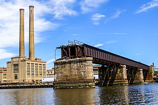
The PD Draw is a partially dismantled railroad bridge on the Passaic River between Newark and Kearny in the US state of New Jersey. It was built as part of Central Railroad of New Jersey branch known as the Newark and New York Railroad. The swing bridge is the first crossing upstream from Newark Bay at mile point 1.2.

<span class="mw-page-title-main">Newark Drawbridge</span> Railroad bridge on the Passaic River between Newark and Harrison, New Jersey, U.S.

The Newark Drawbridge, also known as the Morristown Line Bridge, is a railroad bridge on the Passaic River between Newark and Harrison, New Jersey. The swing bridge is the 11th bridge from the river's mouth at Newark Bay and is 5.85 miles (9.41 km) upstream from it. Opened in 1903, it is owned and operated by New Jersey Transit.

<span class="mw-page-title-main">Lyndhurst Draw</span> Bridge in Clifton and Lyndhurst, New Jersey

The Lyndhurst Draw is a railroad bridge crossing the Passaic River between Clifton and Lyndhurst in northeastern New Jersey. Built in 1903, it is owned and operated by New Jersey Transit Rail Operations (NJT).

<span class="mw-page-title-main">Belleville Turnpike Bridge</span> Bridge in North Arlington, in New Jersey

The Belleville Turnpike Bridge is a vehicular moveable bridge spanning the Passaic River in northeastern New Jersey 8.9 miles (14.3 km) from its river mouth at Newark Bay. Also known as Rutgers Street Bridge and Route 7 Bridge, it is the fourth fixed crossing to be built at the location, today the tripoint of the municipal and county lines of Belleville in Essex, Kearny in Hudson, and North Arlington in Bergen. Commissioned by the New Jersey Department of Transportation, which owns and operates it, the vertical lift bridge opened in 2002.

<span class="mw-page-title-main">Lincoln Highway Hackensack River Bridge</span> Bridge in Jersey City and Kearny

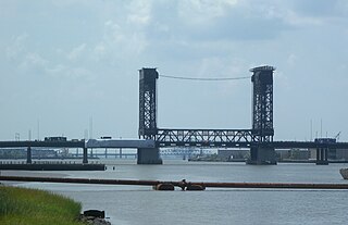
The Lincoln Highway Hackensack River Bridge is a vehicular vertical lift bridge crossing the Hackensack River at a point 1.8 mi (2.9 km) from the river mouth at Newark Bay in Hudson County, New Jersey, United States. The bridge, along the route of the Lincoln Highway, carries U.S. Route 1/9 Truck and the East Coast Greenway between the West Side of Jersey City and Kearny Point in Kearny. The most recent of many crossings at the location, the current bridge was completed in 1954. It is owned by and operated by the New Jersey Department of Transportation (NJDOT), and is required by the Title 33 of the Code of Federal Regulations to open on signal for maritime traffic. In 2007 it was designated the Shawn Carson and Robert Nguyen Memorial Bridge.

<span class="mw-page-title-main">Lincoln Highway Passaic River Bridge</span> Bridge in Newark and Kearny

The Lincoln Highway Passaic River Bridge is a vehicular moveable bridge crossing the Passaic River at a point 1.8 mi (2.9 km) from the river mouth at Newark Bay in northeastern New Jersey, United States. The vertical lift bridge, along the route of the Lincoln Highway, carries U.S. Route 1/9 Truck and the East Coast Greenway between the Ironbound section of Newark and Kearny Point in Kearny. Opened in 1941, it is owned by and operated by the New Jersey Department of Transportation (NJDOT) and required by the Code of Federal Regulations to open on 4-hour notice for maritime traffic.

<span class="mw-page-title-main">Union Avenue Bridge (Passaic River)</span> Bridge in Rutherford & Passaic, New Jersey

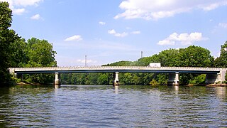
Union Avenue Bridge is a vehicular bridge over the Passaic River in northeastern New Jersey, crossing the county line at the town of Rutherford in Bergen County and the city of Passaic in Passaic County. It takes its name from Union Avenue in Rutherford which connects to River Drive in Passaic. The two-lane, four-span fixed bridge which opened in 2002 is 13.2 miles (21.2 km) from the river's mouth at Newark Bay. There is another Union Avenue Bridge traversing the Passaic at Little Falls

<span class="mw-page-title-main">Ridgefield Park station</span> Railroad station in New Jersey, U.S.

Ridgefield Park station, also known as West Shore Station, was a railroad station in Ridgefield Park, New Jersey, at the foot of Mount Vernon Street served by the New York, Susquehanna and Western Railroad (NYSW) and the West Shore Railroad, a division of New York Central (NYCRR). The New York, Ontario and Western Railway (NYO&W) had running rights along the West Shore and sometimes stopped at Ridgefield Park. First opened in 1872 it was one of three passenger stations in the village, the others being the Little Ferry station to the south and Westview station to the north. Service on the West Shore Railroad began in 1883. The station house, built at a cost $100,000 opened in 1927. Southbound service crossed Overpeck Creek and continued to terminals on the Hudson River waterfront where there was connecting ferry service across the Hudson River to Manhattan. Northbound near Bogota the parallel NYSW and West Shore lines diverge and continue into northern New Jersey, Pennsylvania, and upstate New York. Passenger service ended in 1966.

<span class="mw-page-title-main">Route 46 Passaic River Bridge</span>

The Route 46 Passaic River Bridge can refer to a number of bridges that carry U.S. Route 46 (US 46) over the Passaic River in Northern New Jersey. US 46 was originally developed as Route 6 under the direction of Morris Goodkind who was chief engineer of the New Jersey Highway Department from 1922 until 1955.

<span class="mw-page-title-main">Market Street Bridge (Passaic River)</span> Bridge in Passaic & Wallington, New Jersey

Market Street Bridge, also known as the Second Street Bridge, is a vehicular bridge over the Passaic River crossing the Passaic-Bergen county line in Passaic and Wallington in northeastern New Jersey. The double-leaf bascule bridge was built in 1930 and fixed in the closed position in 1977. It was reconstructed in 2002. It carries a two-lane street and sidewalks in a late-19th and early-20th century industrial area along the river. An earlier structure built at the crossing in 1894 was damaged during the Passaic floods of 1902 and 1903 but survived.

69th Street is a proposed interchange station in North Bergen in Hudson County, New Jersey. It would serve passengers on two lines under consideration by NJ Transit, the Passaic–Bergen–Hudson Transit Project and the Northern Branch Corridor Project, the latter of which is an extension of the Hudson–Bergen Light Rail. The station would located at-grade west the North Bergen Yard and Tonnelle Avenue.