
The Ryde Bridge(s), also called the Uhrs Point Bridge, are two road bridges that carry Concord Road, part of the A3, across Parramatta River from Ryde in the northern suburbs of Sydney to Rhodes in Sydney's inner west, in New South Wales, Australia.

The Market Street Bridge, officially referred to as the John Ross Bridge, is a bascule bridge that spans the Tennessee River between downtown Chattanooga, Tennessee, and the Northshore District. It carries North Market Street, and was named in honor of Cherokee Chief John Ross. The bridge was completed in 1917 at a cost of $1.1 million. In the mid-1970s, the southern terminus of US 127 was moved several miles north to the intersection of Dayton Boulevard and Signal Mountain Boulevard in the nearby suburb of Red Bank.
Paterson Plank Road is a road that runs through Passaic, Bergen and Hudson Counties in northeastern New Jersey. The route, originally laid in the colonial era, connects the city of Paterson and the Hudson River waterfront. It has largely been superseded by Route 3, but in the many towns it passes it has remained an important local thoroughfare, and in some cases been renamed.

Bridge Street Bridge is a swing bridge over the Passaic River connecting Newark and Harrison, New Jersey. It is the 10th bridge from the river's mouth at Newark Bay and is 5.7 miles (9.2 km) upstream from it. Carrying vehicular traffic, the roadway is designated County Route 508.

The Belleville Turnpike Bridge is a vehicular moveable bridge spanning the Passaic River in northeastern New Jersey 8.9 miles (14.3 km) from its river mouth at Newark Bay. Also known as Rutgers Street Bridge and Route 7 Bridge, it is the fourth fixed crossing to be built at the location, today the tripoint of the municipal and county lines of Belleville in Essex, Kearny in Hudson, and North Arlington in Bergen. Commissioned by the New Jersey Department of Transportation, which owns and operates it, the vertical lift bridge opened in 2002.

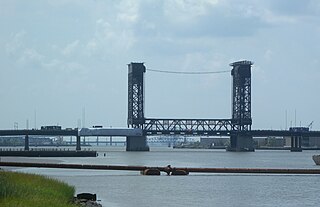
The Winant Avenue Bridge is a vehicular movable bridge spanning the Hackensack River in Bergen County, New Jersey 14 miles (23 km) from its mouth at Newark Bay. Built in 1934, it is also known as the Route 46 Hackensack River Bridge and S46 Bridge, it carries U.S. Route 46 (US 46) in Little Ferry and Ridgefield Park. Owned and operated by the New Jersey Department of Transportation (NJDOT), the double leaf bascule bridge is located on a navigable reach. While there have been no requests since 1978, the Code of Federal Regulations last amended in 1999 requires 24-hour notice to be opened. The bridge has been minimally altered since its construction and is eligible for individual listing on the National Register of Historic Places (NRHP).
The Lincoln Highway Hackensack River Bridge is a vehicular vertical lift bridge crossing the Hackensack River at a point 1.8 mi (2.9 km) from the river mouth at Newark Bay in Hudson County, New Jersey, United States. The bridge, along the route of the Lincoln Highway, carries U.S. Route 1/9 Truck and the East Coast Greenway between the West Side of Jersey City and Kearny Point in Kearny. The most recent of many crossings at the location, the current bridge was completed in 1954. It is owned by and operated by the New Jersey Department of Transportation (NJDOT), and is required by the Title 33 of the Code of Federal Regulations to open on signal for maritime traffic. In 2007 it was designated the Shawn Carson and Robert Nguyen Memorial Bridge.

The Lincoln Highway Passaic River Bridge is a vehicular moveable bridge crossing the Passaic River at a point 1.8 mi (2.9 km) from the river mouth at Newark Bay in northeastern New Jersey, United States. The vertical lift bridge, along the route of the Lincoln Highway, carries U.S. Route 1/9 Truck and the East Coast Greenway between the Ironbound section of Newark and Kearny Point in Kearny. Opened in 1941, it is owned by and operated by the New Jersey Department of Transportation (NJDOT) and required by the Code of Federal Regulations to open on 4-hour notice for maritime traffic.

Eighth Street Bridge is a road bridge over the Passaic River in northeastern New Jersey, United States. Opened in 1915 as a bascule bridge, the bridge was fixed in place in 1977. The Eighth Street Bridge was closed to traffic permanently on July 24, 2017 so work could begin on its replacement, completed in 2019.
Gregory Avenue Bridge, earlier known as the Main Avenue Bridge, is road bridge over the Passaic River in northeastern New Jersey, United States. It is the 7th bridge to be built at the river crossing. Originally built in 1905 as a moveable bridge, it has been in a fixed closed position since 1985. A four lane road carries traffic between Passaic & Wallington at the Passaic and Bergen county line.
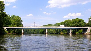
Union Avenue Bridge is a vehicular bridge over the Passaic River in northeastern New Jersey, crossing the county line at the town of Rutherford in Bergen County and the city of Passaic in Passaic County. It takes its name from Union Avenue in Rutherford which connects to River Drive in Passaic. The two-lane, four-span fixed bridge which opened in 2002 is 13.2 miles (21.2 km) from the river's mouth at Newark Bay. There is another Union Avenue Bridge traversing the Passaic at Little Falls
The Passaic Street Bridge is a vehicular bridge crossing the Passaic River in Passaic and Garfield, New Jersey. The girder bridge was built in 1898 and is the third to span the river at that point. It is considered eligible for listing on the New Jersey Register of Historic Places and National Register of Historic Places.

The Straight Street Bridge is a vehicular bridge over the Passaic River in Paterson, New Jersey, that is listed on the National Register of Historic Places.

The Route 46 Passaic River Bridge can refer to a number of bridges that carry U.S. Route 46 (US 46) over the Passaic River in Northern New Jersey. US 46 was originally developed as Route 6 under the direction of Morris Goodkind who was chief engineer of the New Jersey Highway Department from 1922 until 1955.

Arch Street Bridge is Parker truss bridge over the Passaic River in Paterson, New Jersey. It was built in 1907 and rehabilitated in 1997. It was the third structure built at the location within a few years, the other having been destroyed by floods in 1902 and 1903. The bridge was once a crossing for the Public Service trolley lines.
Sixth Avenue Bridge, aka the North Sixth Street Bridge, is a pony truss vehicular bridge over the Passaic River in northeastern New Jersey. It connects the Bunker Hill neighbourhood of Paterson and Prospect Park at the border with Hawthorne via North Sixth Street. It was originally constructed 1907 as a steel structure supported on stone masonry piers and abutments and is one of several bridges built after the Passaic Flood of 1903. The older span opened was abruptly closed in 1986 after the Passaic County engineer at the time, Gaetano Fabrina, found that some steel beams had rusted and were "banging and clanging."

Route 3 Bridge refers to a pair of vehicular bridges over the Hackensack River in Secaucus and East Rutherford, New Jersey. Located in the immediate vicinity of the Meadowlands Sports Complex at milepost 8.50 of New Jersey Route 3, the downstream bridge carries eastbound traffic while the upstream bridge carries westbound traffic. The bridges are often congested, due in part to the distance from other crossings of the river.

