
The New Jersey Turnpike (NJTP) is a system of controlled-access highways in the U.S. state of New Jersey. The turnpike is maintained by the New Jersey Turnpike Authority (NJTA). The 117.20-mile (188.62 km) mainline's southern terminus is at a complex interchange with Interstate 295 (I-295), U.S. Route 40 (US 40), US 130, and Route 49 near the border of Pennsville and Carneys Point townships in Salem County, one mile (1.6 km) east of the Delaware Memorial Bridge. Its northern terminus is at an interchange with I-80 and US 46 in Ridgefield Park. Construction of the mainline from concept to completion took 22 months, from 1950 to 1951. It was opened to traffic on November 5, 1951, between its southern terminus and exit 10.

Route 21 is a state highway in northern New Jersey, running 14.35 mi (23.09 km) from the Newark Airport Interchange with U.S. Route 1/9 (US 1-9) and US 22 in Newark, Essex County to an interchange with US 46 in Clifton, Passaic County. The route is a four- to six-lane divided highway known as McCarter Highway on its southern portion in Newark that serves as a connector between the Newark and Paterson areas, following the west bank of the Passaic River for much of its length. It also serves as the main north–south highway through the central part of Newark, connecting attractions in Downtown Newark with Newark Airport. The portion of Route 21 through Newark is a surface arterial that runs alongside the elevated Northeast Corridor rail line through the southern part of the city and continues north through Downtown Newark while the portion north of Downtown Newark is a freeway. Route 21 intersects many major roads including Interstate 78 (I-78), Route 27, and I-280 in Newark, Route 7 in Belleville, and Route 3 in Clifton.

The Pulaski Skyway is a four-lane bridge-causeway in the northeastern part of the U.S. state of New Jersey, carrying a freeway designated U.S. Route 1/9 (US 1/9) for most of its length. The structure has a total length of 3.502 miles (5.636 km). Its longest bridge spans 550 feet (168 m). Traveling between Newark and Jersey City, the roadway crosses the Passaic and Hackensack rivers, Kearny Point, the peninsula between them, and the New Jersey Meadowlands.

Interstate 280 (I-280) is a 17.85-mile (28.73 km) Interstate Highway in the US state of New Jersey. It provides a spur from I-80 in Parsippany–Troy Hills, Morris County, east to Newark and I-95 in Kearny, Hudson County. In Kearny, access is provided toward the Holland Tunnel and Lincoln Tunnel to New York City. The western part of the route runs through suburban areas of Morris and Essex counties, crossing the Watchung Mountains. Upon reaching The Oranges, the setting becomes more urbanized and I-280 runs along a depressed alignment before ascending again in Newark. I-280 includes a vertical-lift bridge, the William A. Stickel Memorial Bridge, over the Passaic River between Newark and East Newark/Harrison. The highway is sometimes called the Essex Freeway. I-280 interchanges with several roads, including the Garden State Parkway in East Orange and Route 21 in Newark.

The Passaic and Harsimus Line, part of Conrail Shared Assets Operations, serves freight in northeastern New Jersey. It takes trains from the Northeast Corridor and Lehigh Line near Newark Liberty International Airport northeast and east into Jersey City. It is part of CSX's main corridor from upstate New York to the rest of the east coast.
Route 158 was a short state highway in Newark and Harrison, New Jersey, in the counties of Essex and Hudson, which are located in the United States. The Centre Street Bridge was first constructed in 1834 as a single-level railroad bridge. However, in 1911, almost eight decades later, a second, upper level was constructed for rapid transit. In 1937, the Hudson and Manhattan Railroad, now part of the Port Authority Trans-Hudson line, was realigned onto railroad tracks along New Jersey Route 21. The upper level of the bridge was abandoned for this purpose, and was later converted to roadway. At the western end in Newark it ran just south of Park Place, beginning at Center Street. The route headed eastward, crossing over Route 21 and the Passaic River before entering Harrison, where it terminated at Second Street north of New Jersey Railroad Avenue.
Interstate 80 (I-80) is a major Interstate Highway in the United States, running from San Francisco, California, eastward to the New York metropolitan area. In New Jersey, I-80 runs for 68.35 miles (110.00 km) from the Delaware Water Gap Toll Bridge at the Pennsylvania state line to its eastern terminus at I-95 in Teaneck, Bergen County. I-95 continues from the end of I-80 to the George Washington Bridge for access to New York City. The highway runs parallel to U.S. Route 46 (US 46) through rural areas of Warren and Sussex counties before heading into more suburban surroundings in Morris County. As the road continues into Passaic and Bergen counties, it heads into more urban areas. The New Jersey Department of Transportation (NJDOT) identifies I-80 within the state as the Christopher Columbus Highway.

Route 58 is a former state highway in the city of Newark, New Jersey and nearby town of Harrison, New Jersey. The highway ran from Orange and Hecker Streets in Newark, eastbound as a four-lane freeway across the William A. Stickel Memorial Bridge to Harrison, where it terminated at an intersection with County Route 508. The route originates as an alignment of Route 25A, a suffixed spur designated in 1939 of State Highway Route 25. The route was rechristened as Route 58 in the 1953 state highway renumbering. The highway was constructed into Interstate 280 in the 1950s, and the route persisted internally until the 1990s, when it was finally removed as a designation. A stub alignment of Route 58 remains near Hecker and Orange Streets.
Route 75 was a proposed freeway in the U.S. State of New Jersey in the Newark area in the 1960s and 1970s. It was designed to connect the existing Route 21 freeway north of Newark with Interstate 78 (I-78), U.S. Route 1-9 (US 1–9), and Newark Airport. The state of New Jersey applied for interstate status for the route in 1970, but construction of the road remained stalled in courts throughout the 1970s. In 1973, the state of New Jersey and the Federal Highway Administration shelved plans for the route in April 1972, and in 1997, the state of New Jersey officially removed the route from its route logs. Despite its removal, vestiges of Route 75 still remain. The first example is Exit 13 on Interstate 280 eastbound in Newark. The exit is an enormous three lane ramp, while through traffic on I-280 has only two lanes. The ramp comes to a stop at a traffic light on First Street, just south of Orange Street. Also, at Exit 56 off Interstate 78, large flyover ramps meant for a freeway diverge from the roadway, but terminate at city streets.

County Route 508 is a county highway in the U.S. state of New Jersey. The highway extends 16.14 miles (25.97 km) from Mount Pleasant Avenue in Livingston to Belleville Turnpike in Kearny.

Dock Bridge is a pair of vertical lift bridges crossing the Passaic River at Newark, Essex County and Harrison, Hudson County, New Jersey, United States, used exclusively for railroad traffic. It is the seventh crossing from the river's mouth at Newark Bay and is 5.0 miles (8.0 km) upstream from it. Also known as the Amtrak Dock Vertical Lift, it carries Amtrak, NJ Transit, and PATH trains. It is listed on the state and federal registers of historic places.

The Newark Drawbridge, also known as the Morristown Line Bridge, is a railroad bridge on the Passaic River between Newark and Harrison, New Jersey. The swing bridge is the 11th bridge from the river's mouth at Newark Bay and is 5.85 miles (9.41 km) upstream from it. Opened in 1903, it is owned and operated by New Jersey Transit.

The Clay Street Bridge is a bridge on the Passaic River between Newark and East Newark, New Jersey. The swing bridge is the 13th bridge from the river's mouth at Newark Bay and is 6.1 miles (9.8 km) upstream from it. Opened in 1903, the Warren through truss rim-bearing bridge was substantially rehabilitated in 1975–1976, its original working parts are now part of the collection of the Newark Museum. It is listed on the New Jersey Register of Historic Places (ID#5153) and is eligible for the National Register of Historic Places.
Kingsland Avenue Bridge, earlier known as Avondale Bridge and designated the De Jessa Memorial Bridge, is a vehicular movable bridge over the Passaic River in northeastern New Jersey. It crosses the county line to connect the towns of Lyndhurst in Bergen and Nutley in Essex, originally taking its name from the Kingsland section. The bridge is 10.7 miles (17.2 km) from the river's mouth at Newark Bay, and is required to open on four hours' notice. As of 2010, there were 26,420 daily crossings of the bridge, which provides one lane in each direction.

The Winant Avenue Bridge is a vehicular movable bridge spanning the Hackensack River in Bergen County, New Jersey 14 miles (23 km) from its mouth at Newark Bay. Built in 1934, it is also known as the Route 46 Hackensack River Bridge and S46 Bridge, it carries U.S. Route 46 (US 46) in Little Ferry and Ridgefield Park. Owned and operated by the New Jersey Department of Transportation (NJDOT), the double leaf bascule bridge is located on a navigable reach. While there have been no requests since 1978, the Code of Federal Regulations last amended in 1999 requires 24-hour notice to be opened. The bridge has been minimally altered since its construction and is eligible for individual listing on the National Register of Historic Places (NRHP).

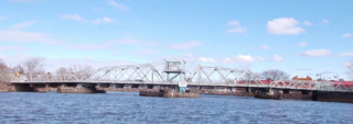
The Chaplain Washington Bridge and the Harry Laderman Bridge, or the Chaplain Washington Memorial Bridge and Laderman Memorial Bridge, are a pair of bridges on the New Jersey Turnpike crossing the Passaic River in northeastern New Jersey. The Washington Bridge built in 1952 and carries the eastern spur of the turnpike; the Laderman Bridge was built in 1970 and carries the western spur.
