Bear Mountain State Park is a 5,205-acre (21.06 km2) state park located on the west bank of the Hudson River in Rockland and Orange counties, New York. The park offers biking, hiking, boating, picnicking, swimming, cross-country skiing, cross-country running, sledding and ice skating. It also includes several facilities such as the Perkins Memorial Tower, the Trailside Museum and Zoo, the Bear Mountain Inn, a merry-go-round, a pool, and a skating rink. It also hosts the Bear Mountain Circle, where the historic Palisades Interstate Parkway and Bear Mountain Bridge meet. It is managed by the Palisades Interstate Park Commission, which is overseen by the State of New York.
At 47,527 acres (192.33 km2), Harriman State Park is the second largest state park in the U.S. state of New York. Located in Rockland and Orange counties 30 miles (48 km) north of New York City, it is a haven for hikers with over 200 miles (320 km) of hiking trails. The park is also known for its 31 lakes, multiple streams, public camping area, and great vistas. The park's hiking trails are currently maintained by volunteers from the New York - New Jersey Trail Conference.

Hudson Highlands State Park is a non-contiguous state park in the U.S. state of New York, located on the east side of the Hudson River. The park runs from Peekskill in Westchester County, through Putnam County, to Beacon in Dutchess County, in the eastern section of the Hudson Highlands.

Arastradero Preserve, officially known as Enid W. Pearson–Arastradero Preserve, is a 622 acres nature preserve that protects most of the Arastradero Creek watershed, including its ephemeral Mayfly Creek tributary. It also includes the upper reach of the Felt Creek tributary to Stanford's Felt Reservoir. The preserve is owned and operated by the City of Palo Alto, California. The main parking lot hosts an interpretive center and is located at 1530 Arastradero Road.
Mills Reservation is a county park, consisting of a 157.15-acre (0.6360 km2) protected wooded area located in Cedar Grove and Montclair, New Jersey, United States. The reservation is maintained by the Essex County Park Commission. The reservation has several walking and jogging trails, including the Lenape Trail, four major trails, and two smaller trails. One of the four main trails leads to a cliff that overlooks the New York City skyline.

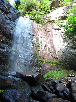
Willow River State Park is a 2,891-acre (1,170 ha) Wisconsin state park located five miles (8 km) north of Hudson. The centerpiece of the park is Willow Falls, a powerful cascade in a 200-foot (61 m) deep gorge. Another popular feature is Little Falls Lake, a shallow reservoir on the Willow River. Because of its proximity to Minneapolis-St. Paul it is one of the most visited state parks in Wisconsin. Trilobite fossils found in the lower layers of the gorge indicate the rock is around 600 million years old.
The Manasquan Reservoir is a source of water for municipalities and utilities, as well as a 1,204-acre (4.87 km2) park, located in Howell Township, in Monmouth County, New Jersey, United States. The reservoir doubles as a park that is part of the Monmouth County Park System. The park has trails, a visitor's center, a nature/environmental center, a boat launching area and several dikes for fishing, among its facilities. The reservoir itself, which is dammed from the Manasquan River, is operated by the New Jersey Water Supply Authority, which is a part of the much larger Raritan Basin Watershed. The nature trails circling around the reservoir are what makes this county park as one of the most popular hiking destinations in Central New Jersey, as the park receives over one million visitors a year. It is reachable by car and there are five parking lots, including one for vehicles hauling trailers. The park's trails are open to walkers, runners, hikers, bicyclists and equestrians.
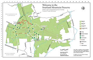
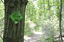
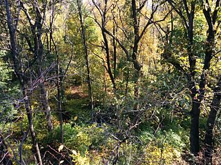
The Sourland Mountain Preserve is located on Sourland Mountain, in the Sourlands region of New Jersey. It is within Hillsborough Township and Montgomery Township of Somerset County. The largest donation of land was made by Norma Gilbert Farr, trustee of the Linus R. Gilbert Foundation. The Farr family has donated over 3,000 acres to the Sourland Mountain Preserve and the Somerset County Parks Commission.

White Clay Creek Preserve is a 3,050-acre (1,230 ha) Pennsylvania state park along the valley of White Clay Creek in London Britain Township in Chester County, Pennsylvania in the United States. The park was donated by the DuPont Company in 1984 for the purpose of "preserving the diverse and unique plant and animal species, and the rich cultural heritage of the area". Dupont also donated an additional 528 acres (214 ha) for the adjoining White Clay Creek State Park to the state of Delaware. White Clay Creek Preserve is 3 miles (4.8 km) north of Newark, Delaware on Pennsylvania Route 896.
Bad Branch Falls State Nature Preserve is a forested gorge covering 2,639 acres near Whitesburg, KY in Letcher County, Kentucky. The deep and narrow gorge, adjacent to the Jefferson National Forest is carved into the face of Pine Mountain. Sandstone boulders and cliffs along with riglines and knobs provide views into the Appalachia area. The terrain is landscaped with streams, rivers, and a 60-foot waterfall. With a variety of habitat types, this nature preserve is home to many unique and unknown species of flora and fauna.

Boyd Big Tree Preserve Conservation Area is a 949.49-acre (384.24 ha) Pennsylvania state park in Lower Paxton and Middle Paxton Townships in Dauphin County, Pennsylvania. The land for the conservation area was donated to the state by real estate developer Alex Boyd in 1999. Boyd Big Tree Preserve Conservation Area is a sanctuary for mature trees and an environment education study area. The park is on Blue Mountain just off Pennsylvania Route 443.

Salt Springs State Park is a Pennsylvania state park in Franklin Township, Susquehanna County, Pennsylvania, in the United States. The park is home to massive hemlock trees that are over 500 years old and are among the largest trees in all of Pennsylvania. The Fall Brook Natural Area within the park is recognized as a part of the Old-Growth Forest Network. The park also features a gorge with three waterfalls on Fall Brook. Salt Springs State Park is 7 miles (11 km) north of Montrose, just off Pennsylvania Route 29. The park is the only state park in Pennsylvania that is managed by a non-profit organization, the Friends of Salt Springs Park. The state owns 405 acres (164 ha) of land and the Friends own an additional 437 acres (177 ha) bringing the total amount of protected land to 842 acres (341 ha).

Frances Slocum State Park is a 1,035-acre (419 ha) Pennsylvania state park in Kingston Township, Luzerne County, Pennsylvania, in the United States. Frances Slocum Lake is a 165-acre (67 ha) man-made, horseshoe-shaped lake that is a popular fishing and boating destination. The park is 5 miles (8.0 km) from Dallas and 10 miles (16 km) from Wilkes-Barre.

Rancho San Antonio County Park and Rancho San Antonio Open Space Preserve are a conjoined public recreational area in the Santa Cruz Mountains, in the northwest quadrant of Santa Clara County, California. The County Park is bordered by Los Altos with some parts of the eastern part of the County Park in western Cupertino. The Open Space Preserve is on the west side of the County Park, also bordered by Los Altos Hills, Monte Bello Open Space Preserve, and the Permanente Quarry.
Splitrock Reservoir is 1,500 acres (610 ha) of wilderness, surrounding a 650 acre reservoir, located on the borders of Rockaway Township and Kinnelon, in Morris County, New Jersey, United States. Splitrock, along with the nearby Boonton Reservoir, provides water for Jersey City, New Jersey. The reservoir is surrounded by woods and can be reached by traveling a mile on a dirt road known as Split Rock Road. The reservoir is three miles from end to end, with many large islands. There is a man-made dam on the southwest end of the reservoir. The reservoir and surrounding natural area were opened to the public on November 21, 2003.

Franklin Lakes Nature Preserve is a 147 acre public nature reserve located mostly within Franklin Lakes, New Jersey, with a tiny portion extending into North Haledon, New Jersey. Situated between the First and Second ridges of the northern Watchung Mountains, the preserve occupies the site of the former Haledon Reservoir, which previously supplied water to North Haledon, Haledon, and Prospect Park. Passive recreation opportunities include hiking, fishing, and bird watching.

Willard Pond is a small, protected lake in Antrim, New Hampshire, United States. The lake, located in southwestern New Hampshire, is about 108 acres (44 ha) in size with an average depth of 25 feet (7.6 m) and a maximum depth of 58 feet (18 m). No petroleum motors are allowed, and fly fishing is the only form of fishing allowed. It is part of the dePierrefeu Wildlife Sanctuary, which is owned by the New Hampshire Audubon Society. Because the pond and the land around it are part of the sanctuary, the shore is unable to be developed. Therefore, there are no buildings around the pond and there won't be any in the foreseeable future. Willard is instead surrounded by extensive amounts of wilderness and hiking trails that lead around the pond and to the summits of Bald Mountain and Goodhue Hill. Willard is a popular fishing, boating and hiking destination, and it has become more popular with its mention in numerous magazines and newspapers.
Franklin Parker Preserve is an 11,379 acre natural preserve located in the Pine Barrens in Chatsworth, New Jersey. The preserve links Brendan Byrne, Wharton, and Penn State Forests. Franklin Parker Preserve is owned and managed by New Jersey Conservation Foundation.

The Hill and Dale Preserve is an approximately 300-acre (120 ha) nature reserve located in Lebanon, New Jersey. The preserve is primarily a combination of open fields and wooded sections. Higher elevations provide scenic views of the Watchung Mountains, Round Valley Reservoir and Cushetunk Mountain. A portion of Rockaway Creek and its tributaries run through the preserve.
The Bear Creek Redwoods Open Space Preserve is a public open space preserve in the Santa Cruz Mountains. The preserve is located along both sides of Bear Creek Road, west of State Route 17 and Lexington Reservoir, and mostly north and east of the Skyline Boulevard and Summit Road sections of State Route 35. It surrounds the Presentation Center, a conference and retreat facility run by the Sisters of Presentation.