A swamp is a forested wetland. Swamps are considered to be transition zones because both land and water play a role in creating this environment. Swamps vary in size and are located all around the world. The water of a swamp may be fresh water, brackish water, or seawater. Freshwater swamps form along large rivers or lakes where they are critically dependent upon rainwater and seasonal flooding to maintain natural water level fluctuations. Saltwater swamps are found along tropical and subtropical coastlines. Some swamps have hammocks, or dry-land protrusions, covered by aquatic vegetation, or vegetation that tolerates periodic inundation or soil saturation. The two main types of swamp are "true" or swamp forests and "transitional" or shrub swamps. In the boreal regions of Canada, the word swamp is colloquially used for what is more formally termed a bog, fen, or muskeg. Some of the world's largest swamps are found along major rivers such as the Amazon, the Mississippi, and the Congo.

The Great Falls of the Passaic River is a prominent waterfall, 77 feet (23 m) high, on the Passaic River in the city of Paterson in Passaic County, New Jersey, United States. The falls and surrounding area are protected as part of the Paterson Great Falls National Historical Park, administered by the National Park Service. The Congress authorized its establishment in 2009.
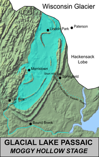
Lake Passaic was a prehistoric proglacial lake that existed in northern New Jersey in the United States at the end of the last ice age approximately 19,000–14,000 years ago. The lake was formed of waters released by the retreating Wisconsin Glacier, which had pushed large quantities of earth and rock ahead of its advance, blocking the previous natural drainage of the ancestral Passaic River through a gap in the central Watchung Mountains. The lake persisted for several thousand years as melting ice and eroding moraine dams slowly drained the former lake basin. The effect of the lake's creation permanently altered the course of the Passaic River, forcing it to take a circuitous route through the northern Watchung Mountains before spilling out into the lower piedmont.

The Great Dismal Swamp is a large swamp in the Coastal Plain Region of southeastern Virginia and northeastern North Carolina, between Norfolk, Virginia, and Elizabeth City, North Carolina. It is located in parts of the southern Virginia independent cities of Chesapeake and Suffolk and northern North Carolina counties of Gates, Pasquotank, and Camden. Some estimates place the size of the original swamp at over one million acres (4,000 km2). The current size of the Great Dismal Swamp is around 750 square miles.

Wawayanda State Park is a 34,350 acres (139.0 km2) state park in Sussex County and Passaic County in northern New Jersey. The park is in Vernon Township on the Sussex side, and West Milford on the Passaic side. There are 60 miles (97 km) of hiking trails in the park, including a 20 miles (32 km) stretch of the Appalachian Trail. The park is operated and maintained by the New Jersey Division of Parks and Forestry. The hiking trails are maintained and updated by the New York - New Jersey Trail Conference.

The National Natural Landmarks (NNL) Program recognizes and encourages the conservation of outstanding examples of the natural history of the United States. It is the only national natural areas program that identifies and recognizes the best examples of biological and geological features in both public and private ownership. The program was established on May 18, 1962, by United States Secretary of the Interior Stewart Udall.

Osceola National Forest is a National Forest located in northeast Florida.

Big Bog State Recreation Area, a recent addition to the Minnesota state park system, is located on Minnesota State Highway 72, north of Waskish, Minnesota. It covers 9,459 acres (38.3 km2), primarily swamps, bogs, and upland "islands".

The Great Swamp National Wildlife Refuge is located in Morris County, New Jersey. Established in 1960, it now is among what has grown to be more than 550 refuges in the United States National Wildlife Refuge System.

The Au Sable State Forest is a state forest in the north-central Lower Peninsula of Michigan. It is operated by the Michigan Department of Natural Resources.

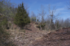
Pigeon Swamp State Park is a 1,078-acre (4.36 km2) New Jersey state park located on Deans Rhode Hall Road in South Brunswick, in Middlesex County, New Jersey, United States. It is an undeveloped park, with a mix of habitats including open ponds and uplands hardwood forests. It also includes a good example of an inner coastal plain lowland deciduous hardwood forest. At one time, it was a major nesting site for passenger pigeons before they became extinct. It was declared a National Natural Landmark in December 1976.

Dendron Swamp Natural Area Preserve is a 636-acre (257 ha) Natural Area Preserve in Sussex County, Virginia, USA. Located along the Blackwater River, the preserve supports a bald cypress and tupelo swamp. Canopy trees over 98 feet (30 m) tall line the river for two miles (3.2 km) and the swamp shows only occasional signs of logging. Some of the larger cypresses are believed to be over 600 years old. Within the preserve is a nesting site for the great blue heron.

Bear Swamp Preserve is a Nature Conservancy preserve and National Natural Landmark in Westerlo, New York. It consists of a pond and surrounding 310 acres (1.3 km2) of swamp and woodland. It is recognized for its great laurel tree population. It has two nature trails totaling about two miles (3.2 km) in length.

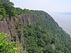
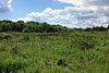
The Moggy Hollow Natural Area is a 14-acre (5.7 ha) nature preserve in Far Hills, Somerset County, New Jersey, United States. As the Wisconsin Glacier advanced, Glacial Lake Passaic formed eventually rising until it found an outlet at Moggy Hollow, draining to the Raritan River. It was designated a National Natural Landmark in January 1970.

Sunfish Pond is a 44-acre (18 ha) glacial lake surrounded by a 258-acre (104 ha) hardwood forest located on the Kittatinny Ridge within Worthington State Forest, adjacent to the Delaware Water Gap National Recreation Area in Warren County, New Jersey. The Appalachian Trail runs alongside the western and northern edges of the lake. It was created by the Wisconsin Glacier during the last ice age. The lake was declared a National Natural Landmark in January 1970.

Troy Meadows is a 3,100-acre (1,300 ha) nature preserve in Parsippany, Morris County, New Jersey. Along with the Great Swamp, it is one of the remnants of Glacial Lake Passaic. It was designated a National Natural Landmark in 1967. It is the largest freshwater marsh in New Jersey, the Whippany River goes through the swamp before connecting with the Rockaway River. It is part of the Northeastern coastal forests ecoregion.
Bear Swamp is a park and open space reserve in Ashfield, Massachusetts.

Brule Glacial Spillway is a Wisconsin Department of Natural Resources-designated State Natural Area that encompasses the valley of the upper reaches of the Bois Brule River. This valley was carved by the outlet of Glacial Lake Duluth, which occupied what is now the western portion of Lake Superior, during the retreat of the Superior lobe of Wisconsin glaciation. This outlet flowed southwestward through the valley, to what is now the St. Croix River. As the glacier melted, and the level of Lake Superior dropped, the direction of flow shifted to its present northeastward course, towards Lake Superior. A high point in a vast bog near Solon Springs marks the Saint Lawrence River Divide between the watersheds of the Gulf of Mexico and the Atlantic Ocean. This divide was used for thousands of years, by Native Americans, European explorers, fur traders, and settlers as a portage between the two watersheds.