List of National Natural Landmarks in Florida

Last updated

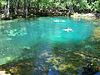
The National Natural Landmarks (NNLs) in Florida include 18 of the almost 600 such landmarks in the United States. They cover areas of geological, biological and historical importance, and include springs, swamps, marshes and seashore. Several of the sites provide habitat for rare or endangered plant and animal species. The landmarks are located in 14 of the state's 67 counties. Four counties each contain all or part of two or more NNLs, while two landmarks is split between two counties. The first designation, Corkscrew Swamp Sanctuary, was made in 1964, while the most recent designation, Archbold Biological Station, was made in 1987. [1] Natural Landmarks in Florida range from 593 to 14,000 acres (240.0 to 5,665.6 ha; 0.9 to 21.9 sq mi) in size. Owners include private individuals and several state and federal agencies. [2]

Contents

The National Natural Landmarks Program is administered by the National Park Service, a branch of the Department of the Interior. The National Park Service determines which properties meet NNL criteria and, after notifying the owners, makes nomination recommendations. The Secretary of the Interior reviews nominations and, based on a set of predetermined criteria, makes a decision on NNL designation or a determination of eligibility for designation. Both public and privately owned properties can be designated as NNLs. Owners may object to the nomination of the property as a NNL. [3] This designation provides indirect, partial protection of the historic integrity of the properties via tax incentives, grants, monitoring of threats, and other means. [4]

National Natural Landmarks

NameImageDateLocationCountyOwnershipDescription
Archbold Biological Station Archbold station.jpg May 1987 27°10′50″N81°21′0″W / 27.18056°N 81.35000°W / 27.18056; -81.35000 (Archbold Biological Station) Highlands PrivateProtects the largest undisturbed tract of the Lake Wales Ridge.
Big Cypress Bend Florida big cyp bend.jpg October 1966 25°51′32″N81°2′2″W / 25.85889°N 81.03389°W / 25.85889; -81.03389 (Big Cypress Bend) Collier StateA part of Fakahatchee Strand Preserve State Park, it features the largest grove of royal palm trees in the country.
Corkscrew Swamp Sanctuary Corkscrew swap sanctuary, Florida.jpg March 1964 26°25′4.41″N81°32′18.33″W / 26.4178917°N 81.5384250°W / 26.4178917; -81.5384250 (Corkscrew Swamp) Collier State, privateContains the nation's largest remaining virgin strand of bald cypress trees.
Devil's Millhopper Devil's Millhopper - 12.jpg December 1974 29°42′25″N82°23′42″W / 29.70694°N 82.39500°W / 29.70694; -82.39500 (Devil's Millhopper) Alachua StateA karst dry sinkhole located within the eponymous state park.
Emeralda Marsh Emeralda Marsh-Island looking west01.jpg December 1974 28°58′1.46″N81°48′13.88″W / 28.9670722°N 81.8038556°W / 28.9670722; -81.8038556 (Emeralda Marsh) Lake, Marion State, privateThis inland freshwater sawgrass marsh is also a popular birding area.
Florida Caverns Natural Area FLCaverns-Jan2007.jpg December 1976 30°48′50″N85°13′59″W / 30.81389°N 85.23306°W / 30.81389; -85.23306 (Florida Caverns Natural Area) Jackson StateEponymous state park protects Florida's only publicly accessible cave. Winter home of the endangered Indiana bat.
Ichetucknee Springs Ichetucknee Springs Headspring.jpg October 1971 29°58′2.47″N82°46′33.82″W / 29.9673528°N 82.7760611°W / 29.9673528; -82.7760611 (Ichetucknee Springs) Columbia, Suwannee StateArtesian spring, the state's third largest, included in eponymous state park.
Lignumvitae Key Florida lignum key.jpg October 1968 24°54′7.18″N80°41′57.56″W / 24.9019944°N 80.6993222°W / 24.9019944; -80.6993222 (Lignumvitae Key) Monroe StateLocated in an eponymous state park, contains the best preserved tropical hammock forest in the country.
Manatee Springs Manatee Springs State Park Florida springs05.jpg December 1971 29°29′25.49″N82°58′37.47″W / 29.4904139°N 82.9770750°W / 29.4904139; -82.9770750 (Manatee Springs) Levy StateAn eponymous state park surrounds the state's sixth largest artesian spring.
Osceola Research Natural Area Florida osce res nat area.jpg December 1974 30°17′26″N82°19′18″W / 30.29056°N 82.32167°W / 30.29056; -82.32167 (Osceola Research Natural Area) Baker FederalIsolated mixed hardwood forest featuring virgin bald cypress strands. A portion of Osceola National Forest.
Paynes Prairie Micanopy Paynes Prairie obs twr view01.jpg December 1974 29°34′1″N82°22′52″W / 29.56694°N 82.38111°W / 29.56694; -82.38111 (Paynes Prairie) Alachua State, privateFreshwater marsh in one of the state's largest sinks. Majority of the site included in Paynes Prairie Preserve State Park.
Rainbow Springs Rainbow spgs florida.JPG October 1971 29°6′9.57″N82°26′13.38″W / 29.1026583°N 82.4370500°W / 29.1026583; -82.4370500 (Rainbow Springs) Marion StateFlorida's second largest artesian spring. Part of an eponymous state park.
Reed Wilderness Seashore Sanctuary Florida reed wild sea sanc.jpg November 1967 27°2′25.64″N80°6′49.47″W / 27.0404556°N 80.1137417°W / 27.0404556; -80.1137417 (Reed Wilderness Seashore Sanctuary) Martin FederalA part of Hobe Sound National Wildlife Refuge, protects the largest undisturbed stretch of Florida's Atlantic coast. A nesting site of the loggerhead turtle.
San Felasco Hammock San Felasco Hammock pano01.jpg December 1974 29°43′44″N82°26′31″W / 29.72889°N 82.44194°W / 29.72889; -82.44194 (San Felasco Hammock) Alachua State, privateMainly located in San Felasco Hammock Preserve State Park, contains a diverse forest environment.
Silver Springs Steamboat approaching Silver Springs FL George Barker.jpg October 1971 29°12′59″N82°3′28″W / 29.21639°N 82.05778°W / 29.21639; -82.05778 (Silver Springs) Marion PrivateEponymous state park surrounds the state's largest artesian spring.
Torreya State Park Torreya Park Bluffs01.jpg December 1976 30°34′8″N84°56′53″W / 30.56889°N 84.94806°W / 30.56889; -84.94806 (Torreya State Park) Liberty StateSteep ravines cut through this eponymous state park. Home of endangered plants such as the Florida yew.
Waccasassa Bay Preserve State Park Florida wacca bay.jpg December 1976 29°10′44.37″N82°55′50.31″W / 29.1789917°N 82.9306417°W / 29.1789917; -82.9306417 (Waccasassa Bay Preserve State Park) Levy StateBrackish mangrove protected in an eponymous state park.
Wakulla Springs Florida wak springs.jpg October 1966 30°13′58″N84°17′32″W / 30.23278°N 84.29222°W / 30.23278; -84.29222 (Wakulla Springs) Wakulla StateLocated in Edward Ball Wakulla Springs State Park, includes the state's deepest artesian spring.

See also

Related Research Articles

<span class="mw-page-title-main">National Natural Landmark</span> Natural areas program in the U.S.

The National Natural Landmarks (NNL) Program recognizes and encourages the conservation of outstanding examples of the natural history of the United States. It is the only national natural areas program that identifies and recognizes the best examples of biological and geological features in both public and private ownership. The program was established on May 18, 1962, by United States Secretary of the Interior Stewart Udall.

<span class="mw-page-title-main">National Register of Historic Places listings in Hartford County, Connecticut</span>

This is a list of the National Register of Historic Places designations in Hartford County, Connecticut.

References

General
Specific
  1. "National Registry of Natural Landmarks" (PDF). National Park Service. June 2009. pp. Introduction, 18–22. Retrieved 2014-05-22.
  2. "Florida". National Park Service. June 28, 2012. Retrieved 2014-05-22.
  3. "36 CFR Part 62: National Natural Landmarks Program, Final Rule" (PDF). Federal Register. May 12, 1999. Retrieved 2014-03-01.
  4. "Frequently Asked Questions". National Park Service. Retrieved 2014-03-01.