List of National Natural Landmarks in Oregon

Last updated

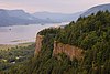
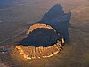
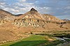
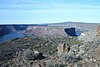
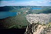
From List of National Natural Landmarks, these are the National Natural Landmarks in the U.S. state of Oregon. [1]

NameImageDateLocationCountyOwnershipDescription
1 Crown Point Vistahouse.jpg 1971 45°32′22″N122°14′39″W / 45.5395°N 122.24422°W / 45.5395; -122.24422 (Crown Point) Multnomah state park Promontory in Columbia Gorge
2 Fort Rock State Monument Fortrock.jpg 1976 43°22′19″N121°04′26″W / 43.372°N 121.074°W / 43.372; -121.074 (Fort Rock) Lake state parkVolcanic tuff ring
3 Horse Ridge Natural Area Badlands Landscape (11410988234).jpg 1967 43°55′26″N121°02′20″W / 43.924°N 121.039°W / 43.924; -121.039 (Horse Ridge) [2] Deschutes federalWestern juniper woodland on Bureau of Land Management property. [2]
4 John Day Fossil Beds Sheep Rock near sunset.jpg 1966 44°33′21″N119°38′43″W / 44.555833°N 119.645278°W / 44.555833; -119.645278 (John Day Fossil Beds) Grant federalContains a remarkable sequence of very diverse fossils.
5 The Island Cove Palisades SP Oregon 2002.03.31.jpg 2011 44°33′31″N121°16′38″W / 44.558489°N 121.277143°W / 44.558489; -121.277143 (The Island) Jefferson federalNative juniper savanna on an isolated plateau at the confluence of the Deschutes and Crooked Rivers. Part of Ochoco National Forest.
6 Lawrence Memorial Grassland Preserve 1984 44°57′03″N120°47′56″W / 44.950889°N 120.7988834°W / 44.950889; -120.7988834 (Lawrence Memorial Grassland Preserve) Oregon privateAn excellent illustration of "biscuit and scabland" topography. [3]
7 Newberry Crater Newberry caldera.jpg 1976 43°41′21″N121°15′18″W / 43.689194°N 121.254889°W / 43.689194; -121.254889 (Newberry Volcano) Deschutes federalAtypical shield volcano in Deschutes National Forest.
8 Mount Howard-East Peak Mount Howard, Oregon.jpg 2016 45°15′40″N117°10′44″W / 45.260987°N 117.178778°W / 45.260987; -117.178778 (Mount Howard-East Peak) Wallowa federalContains botanically diverse montane grassland habitats and populations of endemic and rare plant species.
9 Round Top Butte 2011 42°31′40″N122°41′02″W / 42.5277551°N 122.68381°W / 42.5277551; -122.68381 (Newberry Volcano) [4] Jackson federalExceptional native bunchgrass habitat. Located on Bureau of Land Management land. [5] [6]
10 Willamette Floodplain Willamette Floodplain.jpg 1987 44°21′50″N123°13′48″W / 44.364°N 123.23°W / 44.364; -123.23 (Willamette Floodplain) Benton, Lane, Linn, Marion, Polk federalA bottomland interior valley grassland floodplain. Part of William L. Finley National Wildlife Refuge.
11 Zumwalt Prairie Zumwalt prairie 2007.jpg 2013 45°32′N117°05′W / 45.54°N 117.09°W / 45.54; -117.09 (Zumwalt Prairie) Wallowa privateLargest contiguous remaining tract of bunchgrass prairie in the nation.

See also

Related Research Articles

This is a list of the 135 National Register of Historic Places listings in Cook County, Illinois outside Chicago and Evanston. Separate lists are provided for the 62 listed properties and historic districts in Evanston and the more than 350 listed properties and districts in in Chicago. The Chicago Sanitary and Ship Canal Historic District extends through the West Side of Chicago, DuPage County and Will County to Lockport.

<span class="mw-page-title-main">National Register of Historic Places listings in Los Angeles County, California</span>

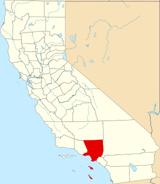
This is a list of the National Register of Historic Places listings in Los Angeles County, California.

<span class="mw-page-title-main">National Register of Historic Places listings in Newport County, Rhode Island</span>

This is a list of the National Register of Historic Places listings in Newport County, Rhode Island.

<span class="mw-page-title-main">National Register of Historic Places listings in Vigo County, Indiana</span>

This is intended to be a complete list of the properties and districts on the National Register of Historic Places in Vigo County, Indiana, United States. Latitude and longitude coordinates are provided for many National Register properties and districts; these locations may be seen together in a map.

This is a list of the National Register of Historic Places listings in Sevier County, Tennessee.

<span class="mw-page-title-main">National Register of Historic Places listings in Cameron County, Texas</span>

This is a list of the National Register of Historic Places listings in Cameron County, Texas.

Robert T. Lackey is a Canadian born fisheries scientist and political scientist living in the United States. He is best known for his work involving the interplay between science and policy, natural resource management, and assessments of the future of salmon runs. Lackey is a professor of fisheries and wildlife and adjunct professor of political science at Oregon State University. From 1981-2008, he held senior leadership posts at the United States Environmental Protection Agency research laboratory in Corvallis, Oregon.

<span class="mw-page-title-main">National Register of Historic Places listings in Hunt County, Texas</span>

This is a list of the National Register of Historic Places listings in Hunt County, Texas.

<span class="mw-page-title-main">National Register of Historic Places listings in inner Harris County, Texas</span>

This is a list of the National Register of Historic Places in inner Harris County, Texas, defined as within the I-610 loop within Harris County, Texas, but excluding those places in Downtown Houston and those in Houston Heights, which are listed separately.

Oregon Agricultural Experiment Station (OAES) is affiliated with Oregon State University and coordinates research at experiment stations in Oregon. It receives state funding and funding from contracts for its work. It has 11 branch stations. It was established in 1887 after passage of the Hatch Act of 1887 and began at Oregon Agricultural College in 1888. It publishes a station bulletin. It also produced films and public service announcements. Rural homemaking practices were studied when female researchers were added to the organization. Publication topics have included studies on soils, pests, and crops.

References

  1. Hale, Jamie (August 10, 2016). "Oregon Travel News: Oregon's 11 National Natural Landmarks". The Oregonian. Oregonlive / The Oregonian. Retrieved 2017-08-10.
  2. 1 2 "Horse Ridge Natural Area". Geographic Names Information System . United States Geological Survey, United States Department of the Interior . Retrieved 2009-04-05.
  3. "Lawrence Memorial Grassland Preserve". Conservation Gateway. The Nature Conservancy. Retrieved 2017-08-10.
  4. "Round Top Butte RNA". Pacific Northwest Interagency Natural Areas Network. Oregon State University, Forestry Sciences Laboratory. Retrieved 2017-08-31.
  5. https://www.fs.fed.us/pnw/pubs/pnw_gtr895.pdf [ bare URL PDF ]
  6. http://inr.oregonstate.edu/sites/inr.oregonstate.edu/files/2015_or_natural_areas_plan.pdf [ bare URL PDF ]