Route 7 is a state highway in the northern part of New Jersey in the United States. It has two sections, an east–west alignment running from U.S. Route 1/9 Truck in Jersey City to Route 21 in Belleville, and a north–south alignment running from the Newark/Belleville to the Nutley/Clifton border. The New Jersey Department of Transportation (NJDOT) lists Route 7 as a single north–south highway with a small gap between the alignments. The entire highway has a combined length of 9.46 mi (15.22 km).

Route 17 is a state highway in Bergen County, New Jersey, United States, that provides a major route from the George Washington Bridge, Lincoln Tunnel and other northeast New Jersey points to the New York State Thruway at Suffern, New York. It runs 27.20 mi (43.77 km) from an intersection with Route 7 and County Route 507 (CR 507) in North Arlington north to the New York border along Interstate 287 (I-287) in Mahwah, where New York State Route 17 (NY 17) continues into New York. Between Route 7 and Route 3 in Rutherford, Route 17 serves as a local road. From Route 3 north to the junction with U.S. Route 46 (US 46) in Hasbrouck Heights, the road is an expressway with jughandles. The portion of Route 17 from US 46 to I-287 near the state line in Mahwah is a limited-access highway with all cross traffic handled by interchanges, and many driveways and side streets accessed from right-in/right-out ramps from the right lane. For three miles (5 km) north of Route 4, well over a hundred retail stores and several large shopping malls line the route in the borough of Paramus. The remainder of this portion of Route 17 features lighter suburban development. The northernmost portion of Route 17 in Mahwah runs concurrently with I-287 to the New York border.

Lyndhurst is a township in Bergen County, in the U.S. state of New Jersey. As of the 2020 United States census, the township's population was 22,519, an increase of 1,965 (+9.6%) from the 2010 census count of 20,554, which in turn reflected an increase of 1,171 (+6.0%) from the 19,383 counted in the 2000 census.

The Main Line is a commuter rail line owned and operated by New Jersey Transit running from Suffern, New York to Hoboken, New Jersey, in the United States. It runs daily commuter service and was once the north–south main line of the Erie Railroad. It is colored yellow on NJ Transit system maps, and its symbol is a water wheel.

NJ Transit Rail Operations is the rail division of NJ Transit. It operates commuter rail service in New Jersey, with most service centered on transportation to and from New York City, Hoboken, and Newark. NJ Transit also operates rail service in Orange and Rockland counties in New York under contract to Metro-North Railroad. The commuter rail lines saw 45,838,200 riders in 2022, making it the third-busiest commuter railroad in North America and the longest commuter rail system in North America by route length.

Kingsland is a railroad station on New Jersey Transit's Main Line. It is located under Ridge Road (Route 17) between New York and Valley Brook Avenues in Lyndhurst, New Jersey, and is one of two stations in Lyndhurst. The station is not staffed, and passengers use ticket vending machines (TVMs) located at street level to purchase tickets. The station is not handicapped-accessible. Originally part of the Delaware, Lackawanna and Western Railroad's Boonton Branch, the current Kingsland station was built in 1918.

The Passaic–Bergen–Hudson Transit Project is a project under study by NJ Transit to reintroduce passenger service on a portion of the New York, Susquehanna and Western Railway (NYSW) right-of-way (ROW) in Passaic, Bergen and Hudson counties using newly built, FRA-compliant diesel multiple unit rail cars. Plans call for service to run from Hawthorne south through Paterson, east to Hackensack and then southeast to North Bergen, where it would join the Hudson-Bergen Light Rail (HBLR).

New Barbadoes Neck is the name given in the colonial era for the peninsula in northeastern New Jersey, US between the lower Hackensack and Passaic Rivers, in what is now western Hudson County and southern Bergen County. The neck begins in the south at Kearny Point in the Newark Bay and is characterized by a ridge along the west and part of the New Jersey Meadowlands on the east.
The North Jersey Transportation Planning Authority (NJTPA) is the federally authorized metropolitan planning organization (MPO) for the 13-county northern New Jersey region, one of three MPOs in the state. NJTPA's annual budget is more than $2 billion for transportation improvement projects. The Authority also participates in inter-agency cooperation and receives public input into funding decisions. The NJTPA sponsors and conducts studies, assists county planning agencies and monitors compliance with national air quality goals. The Authority provides federal funding to support the planning work of its 15 subregions. The funds are matched by a local contribution. As vital partners in regional planning work, the subregions help bring a local perspective to all aspects of NJTPA's work to improve the northern New Jersey transportation network.
There are three metropolitan planning organizations (MPO) in New Jersey. The organizations are the main decision-making forums for selecting projects for the Statewide Transportation Improvement Program (STIP) in deliberations involving the New Jersey Department of Transportation (NJDOT), the New Jersey Transit Corporation (NJT), county and municipal transportation planners and engineers, other transportation implementing agencies, the public and elected officials at the state, county, and municipal levels.

Bus rapid transit in New Jersey comprises limited-stop bus service, exclusive bus lanes (XBL) and bus bypass shoulders (BBS). Under the banner Next Generation Bus New Jersey Transit (NJT), the New Jersey Department of Transportation (NJDOT), and the metropolitan planning organizations of New Jersey (MPO) which recommend and authorize transportation projects are undertaking the creation of several additional bus rapid transit systems (BRT) in the state.

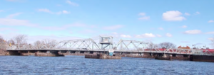
The Belleville Turnpike Bridge is a vehicular moveable bridge spanning the Passaic River in northeastern New Jersey 8.9 miles (14.3 km) from its river mouth at Newark Bay. Also known as Rutgers Street Bridge and Route 7 Bridge, it is the fourth fixed crossing to be built at the location, today the tripoint of the municipal and county lines of Belleville in Essex, Kearny in Hudson, and North Arlington in Bergen. Commissioned by the New Jersey Department of Transportation, which owns and operates it, the vertical lift bridge opened in 2002.

The Court Street Bridge, also known as the Harold J. Dillard Memorial Bridge, is a vehicular movable bridge crossing the Hackensack River between Hackensack and Bogota in Bergen County, New Jersey, which owns it. Located 16.2 miles (26.1 km) from the river mouth at Newark Bay, the swing bridge, which opened in 1908 and underwent major rehabilitation in 2010–2012, is the most-upstream bridge on the river required by federal regulations to open on request.
Gregory Avenue Bridge, earlier known as the Main Avenue Bridge, is road bridge over the Passaic River in northeastern New Jersey, United States. It is the 7th bridge to be built at the river crossing. Originally built in 1905 as a moveable bridge, it has been in a fixed closed position since 1985. A four lane road carries traffic between Passaic & Wallington at the Passaic and Bergen county line.
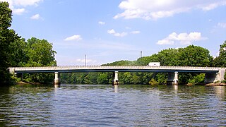
Union Avenue Bridge is a vehicular bridge over the Passaic River in northeastern New Jersey, crossing the county line at the town of Rutherford in Bergen County and the city of Passaic in Passaic County. It takes its name from Union Avenue in Rutherford which connects to River Drive in Passaic. The two-lane, four-span fixed bridge which opened in 2002 is 13.2 miles (21.2 km) from the river's mouth at Newark Bay. There is another Union Avenue Bridge traversing the Passaic at Little Falls
The Anderson Street Bridge, also known as the Cedar Lane Bridge, is a fixed-span road bridge over the Hackensack River in Hackensack and Teaneck in Bergen County, New Jersey, U.S. The crossing was built in 1971 to replace an earlier structure. Being structurally deficient, the bridge was given weight restrictions in 2012 and was partially closed in 2016 for interim repairs. It is one of several bridges over the river in Hackensack, including the Court Street Bridge, the Midtown Bridge, and those that carry Interstate 80 and Route 4.

Arch Street Bridge is Parker truss bridge over the Passaic River in Paterson, New Jersey. It was built in 1907 and rehabilitated in 1997. It was the third structure built at the location within a few years, the other having been destroyed by floods in 1902 and 1903. The bridge was once a crossing for the Public Service trolley lines.
Sixth Avenue Bridge, aka the North Sixth Street Bridge, is a pony truss vehicular bridge over the Passaic River in northeastern New Jersey. It connects the Bunker Hill neighbourhood of Paterson and Prospect Park at the border with Hawthorne via North Sixth Street. It was originally constructed 1907 as a steel structure supported on stone masonry piers and abutments and is one of several bridges built after the Passaic Flood of 1903. The older span opened was abruptly closed in 1986 after the Passaic County engineer at the time, Gaetano Fabrina, found that some steel beams had rusted and were "banging and clanging."