Island Beach State Park, New Jersey

Last updated

Island Beach State Park, New Jersey
2013-08-21 12 34 24 Wetlands along Barnegat Bay near the southern end of Island Beach State Park, New Jersey.jpg
Wetlands along Barnegat Bay near the southern end of Island Beach State Park
USA New Jersey location map.svg
Red pog.svg
Location in New Jersey
Usa edcp location map.svg
Red pog.svg
Location in United States
Location Berkeley Township, New Jersey
Nearest city Seaside Park, New Jersey
Coordinates 39°54′18.98″N74°4′53.15″W / 39.9052722°N 74.0814306°W / 39.9052722; -74.0814306 [1]
Area3,003 acres (1,215 ha)
Established1953
Administered by New Jersey Division of Parks and Forestry
Website Official website OOjs UI icon edit-ltr-progressive.svg

Island Beach State Park is a New Jersey state park located just south of Seaside Park on the Barnegat Peninsula in Berkeley Township, Ocean County, New Jersey, United States. The park is operated and maintained by the New Jersey Division of Parks and Forestry. Most of the park encompasses the former borough of Island Beach.

Contents

The park is the largest reserve of undeveloped barrier island in New Jersey and one of the largest in the United States. [2] The park is divided into two areas. The Island Beach Northern Natural Area covers 659 acres (2.7 km2), some of which is restricted to the public. The Southern Natural Area is much larger at 1,237 acres (5 km2). The park includes the Sedge Island Marine Conservation Zone, which includes about 1,600 acres (6 km2) of tidal marshes, creeks, ponds, and open water.

Coming in from the sea-front, a visitor ascends over a large primary dune covered in tall grasses and down into a narrow maritime forest, consisting of many tall bushes and short trees including holly, goldenrod and black cherry. Approaching the bay side, one finds reeds and a muddy estuary that is home to blue crabs and herons and other marine birds. The park is an excellent site for bird watching with osprey nests and bird blinds set up. [3] The Barnegat Inlet is located at the southern tip of the park, separating the Barnegat Peninsula from Long Beach Island.

Swimming, kayaking, and fishing are permitted in some areas of the park. Four wheel drive vehicles are permitted onto the beach with a permit.

Flora

Typical flora of Island Beach State Park, as seen along Shore Road, the main road through the park. IslandBeachRoad.jpg
Typical flora of Island Beach State Park, as seen along Shore Road, the main road through the park.

Among the trees found in the park are Eastern Redcedar ( Juniperus virginiana ), Pitch Pine ( Pinus rigida ), American Holly ( Ilex opaca ), Black Cherry ( Prunus serotina ), Serviceberry ( Amelanchier canadensis ), Persimmon ( Diospyros virginiana ), Atlantic White Cedar ( Chamaecyparis thyoides ) and Sweetbay ( Magnolia virginiana ). These trees appear in different areas of the park, depending on the specifics of salt and wind exposure. They are often stunted, compared to inland examples of their species, and display the "salt spray horizon" effect, with the side facing the ocean sheared tightly by the environment, with their westerly sides tending to grow taller. Thus, the trees and shrubs often take on wedge-like shapes with their low side on the east.

Shrubs in the park include Bayberry ( Myrica pensylvanica and Myrica cerifera ), Highbush blueberry ( Vaccinium corymbosum ), Beach plum ( Prunus maritima ), Swamp azalea ( Rhododendron viscosum ), Red and Black Chokeberry ( Aronia arbutifolia and Aronia melanocarpa ), Heather ( Hudsonia ericoides ) and Sweet Pepperbush ( Clethra alnifolia ). Every September the park hosts an exciting Beach Plum Festival, replete with tours, foods, music and great atmosphere.

There are also many grasses, forbs and herbaceous plants.

Many of these plants can be seen at the nature center, 1 mile (1.6 km) into the park, in a display garden, which is located by a freshwater wetland.

Attractions

Bathing beach at Island Beach State Park on a sunny summer day 2013-08-21 14 49 33 View north up the beach from the middle of the beach at Bathing Beach Number 1 in Island Beach State Park.jpg
Bathing beach at Island Beach State Park on a sunny summer day

Most visitors come for the white sand beach, the ocean waters, and natural backdrop, in contrast to the developed and boardwalk-lined beaches to the north and south. Island Beach State Park encompasses many miles of beach; the northernmost have life guards. People can swim, surf, fish, and kayak in the park. The park also allows dune buggy access in the southern portion of the park. There is also a boardwalk extending from Barnegat Bay to the main road allowing boaters access to the beach. On the bayside of Island Beach State Park is an area called Tices Shoal, where boaters gather together and anchor.

Governor’s Ocean Residence

Since New Jersey acquired the 2,694 acres (10.90 km2) estate of Henry Phipps, Jr. in 1953 for $2.75 million to form the park, the state has maintained an official vacation residence ( 39°53′11″N74°04′55″W / 39.8865°N 74.0819°W / 39.8865; -74.0819 ) exclusively for the New Jersey Governor (in addition to the governor's mansion at Drumthwacket, in Princeton near the state capital of Trenton). [4] [5] The residence was built by Phipps in the 1920s. [6]

The house is in the Cape Cod style. [5] It is now accessible via a paved road. The home is about 200 feet (61 m) from the beach. It has five bedrooms and three bathrooms with a small room for the security detail. It is the only house close to the ocean. Two other houses in the park are on Barnegat Bay (one for the superintendent of the park and a governor's guest house). [7]

In addition to the governors, guests at the house have included Lady Bird Johnson; the daughter of Alexei Kosygin; Hubert Humphrey; Walter Mondale; and Joe Biden. [8]

In July 2017 during the long July 4th holiday extended weekend the park along with other parks were closed because the state had not approved its budget. Governor Chris Christie, wife, children and friends were photographed on a deserted beach at the park. Christie took a helicopter back and forth to Trenton during the budget discussions. [4]

New Jersey is one of just four states to maintain a state-owned vacation home for its governor. [5] Other states with vacation residence are Alabama at Fort Morgan, [9] Michigan at Mackinac Island [10] and North Carolina at Asheville. [11]

Climate

According to the Köppen climate classification system, Island Beach State Park has a humid subtropical climate (Cfa). Cfa climates are characterized by all months having an average temperature > 32.0 °F (0.0 °C), at least four months with an average temperature ≥ 50.0 °F (10.0 °C), at least one month with an average temperature ≥ 71.6 °F (22.0 °C) and no significant precipitation difference between seasons. Although most summer days are slightly humid with a cooling afternoon sea breeze in Island Beach State Park, episodes of heat and high humidity can occur with heat index values > 104 °F (40 °C). Since 1981, the highest air temperature was 99.5 °F (37.5 °C) on July 5, 1999 and the highest daily average mean dew point was 77.2 °F (25.1 °C) on August 13, 2016. July is the peak in thunderstorm activity and the average wettest month is August. Since 1981, the wettest calendar day was 6.70 inches (170 mm) on August 12, 2013. During the winter months, the average annual extreme minimum air temperature is 3.7 °F (−15.7 °C). [12] Since 1981, the coldest air temperature was −4.2 °F (−20.1 °C) on January 18, 1982. Episodes of extreme cold and wind can occur with wind chill values < −6 °F (−21 °C). The average seasonal (Nov-Apr) snowfall total is between 12 inches (30 cm) and 18 inches (46 cm), and the average snowiest month is February which corresponds with the annual peak in nor'easter activity.

Climate data for Island Beach State Park, 1981-2010 normals, extremes 1981-2019
MonthJanFebMarAprMayJunJulAugSepOctNovDecYear
Record high °F (°C)70.5
(21.4)
77.5
(25.3)
83.3
(28.5)
87.9
(31.1)
94.6
(34.8)
97.2
(36.2)
99.5
(37.5)
98.9
(37.2)
97.0
(36.1)
91.9
(33.3)
79.2
(26.2)
73.9
(23.3)
99.5
(37.5)
Average high °F (°C)40.2
(4.6)
42.6
(5.9)
49.3
(9.6)
58.6
(14.8)
68.5
(20.3)
77.8
(25.4)
82.9
(28.3)
81.9
(27.7)
76.0
(24.4)
65.3
(18.5)
55.2
(12.9)
45.4
(7.4)
62.1
(16.7)
Daily mean °F (°C)32.9
(0.5)
34.9
(1.6)
41.3
(5.2)
50.4
(10.2)
60.3
(15.7)
69.7
(20.9)
75.0
(23.9)
74.1
(23.4)
67.6
(19.8)
56.5
(13.6)
47.2
(8.4)
37.8
(3.2)
54.1
(12.3)
Average low °F (°C)25.6
(−3.6)
27.2
(−2.7)
33.3
(0.7)
42.2
(5.7)
52.0
(11.1)
61.7
(16.5)
67.2
(19.6)
66.2
(19.0)
59.3
(15.2)
47.7
(8.7)
39.3
(4.1)
30.1
(−1.1)
46.1
(7.8)
Record low °F (°C)−4.2
(−20.1)
−0.2
(−17.9)
7.5
(−13.6)
18.7
(−7.4)
37.4
(3.0)
45.4
(7.4)
50.9
(10.5)
46.4
(8.0)
41.8
(5.4)
29.3
(−1.5)
16.9
(−8.4)
0.9
(−17.3)
−4.2
(−20.1)
Average precipitation inches (mm)3.62
(92)
3.03
(77)
4.27
(108)
3.85
(98)
3.50
(89)
3.56
(90)
4.40
(112)
4.47
(114)
3.49
(89)
3.70
(94)
3.70
(94)
3.87
(98)
45.46
(1,155)
Average relative humidity (%)66.063.962.163.366.070.870.171.871.169.968.966.767.6
Average dew point °F (°C)22.8
(−5.1)
23.9
(−4.5)
29.3
(−1.5)
38.4
(3.6)
48.9
(9.4)
59.8
(15.4)
64.6
(18.1)
64.4
(18.0)
57.9
(14.4)
46.8
(8.2)
37.5
(3.1)
27.7
(−2.4)
43.6
(6.4)
Source: PRISM [13]


Climate data for Atlantic City, NJ Ocean Water Temperature (38 SW Island Beach State Park)
MonthJanFebMarAprMayJunJulAugSepOctNovDecYear
Daily mean °F (°C)37
(3)
35
(2)
42
(6)
48
(9)
56
(13)
63
(17)
70
(21)
73
(23)
70
(21)
61
(16)
53
(12)
44
(7)
54
(12)
Source: NOAA [14]

Ecology

According to the A. W. Kuchler U.S. potential natural vegetation types, Island Beach State Park would have a dominant vegetation type of Northern Cordgrass (73) with a dominant vegetation form of Coastal Prairie (20). [15] The plant hardiness zone is 7a with an average annual extreme minimum air temperature of 3.7 °F (−15.7 °C). [12] The average date of first spring leaf-out is March 23 [16] and fall color typically peaks in early-November.

Related Research Articles

<span class="mw-page-title-main">Ocean County, New Jersey</span> County in New Jersey, United States

Ocean County is a county located along the Jersey Shore in the south-central portion of the U.S. state of New Jersey, and the southernmost county in the New York metropolitan area. It is the only U.S. county named Ocean. The county borders the Atlantic Ocean on the east and in terms of total area is the state's largest county. Its county seat is Toms River.

<span class="mw-page-title-main">Barnegat Light, New Jersey</span> Borough in Ocean County, New Jersey, United States

Barnegat Light is a borough in Ocean County, in the U.S. state of New Jersey. As of the 2020 United States census, the borough's population was 640, an increase of 66 (+11.5%) from the 2010 census count of 574, which in turn reflected a decline of 190 (−24.9%) from the 764 counted in the 2000 census. The borough borders the Atlantic Ocean on Long Beach Island and is home to Barnegat Lighthouse.

<span class="mw-page-title-main">Beach Haven, New Jersey</span> Borough in Ocean County, New Jersey, United States

Beach Haven is a borough situated on the Jersey Shore in southern Ocean County, in the U.S. state of New Jersey. The borough is located on Long Beach Island (LBI) and borders the Atlantic Ocean. As of the 2020 United States census, the borough's population was 1,027, a decrease of 143 (−12.2%) from the 2010 census count of 1,170, which in turn reflected a decline of 108 (−8.5%) from the 1,278 counted in the 2000 census.

<span class="mw-page-title-main">Dover Beaches North, New Jersey</span> Populated place in Ocean County, New Jersey, US

Dover Beaches North is an unincorporated community and census-designated place (CDP) located within Toms River, in Ocean County, in the U.S. state of New Jersey. As of the 2010 United States Census, the CDP's population was 1,239. The CDP includes the communities of Ocean Beaches 1, 2 and 3, Chadwick Beach, Chadwick Island, Seacrest Beach, Monterey Beach, Silver Beach, Normandy Shores and half of Normandy Beach. Dover Beaches North is situated on the Barnegat Peninsula, a long, narrow barrier peninsula that separates Barnegat Bay from the Atlantic Ocean.

<span class="mw-page-title-main">Dover Beaches South, New Jersey</span> Populated place in Ocean County, New Jersey, US

Dover Beaches South, more commonly known as Ortley Beach, is an unincorporated community and census-designated place (CDP) located within Toms River, in Ocean County, in the U.S. state of New Jersey. As of the 2010 United States Census, the CDP's population was 1,209. Dover Beaches South is situated on the Barnegat Peninsula, a long, narrow barrier peninsula that separates Barnegat Bay from the Atlantic Ocean.

<span class="mw-page-title-main">Harvey Cedars, New Jersey</span> Borough in Ocean County, New Jersey, United States

Harvey Cedars is a coastal borough situated on the Jersey Shore, in southern Ocean County, in the U.S. state of New Jersey. The borough encompasses a narrow strip of Long Beach Island fronting both the Atlantic Ocean and Barnegat Bay. As of the 2020 United States census, the borough's population was 391, its highest decennial count ever and an increase of 54 (+16.0%) from the 2010 census count of 337, which in turn reflected a decline of 22 (−6.1%) from the 359 counted in the 2000 census.

<span class="mw-page-title-main">Lavallette, New Jersey</span> Borough in Ocean County, New Jersey, United States

Lavallette is a borough situated on the Jersey Shore, in Ocean County, in the U.S. state of New Jersey. As of the 2020 United States census, the borough's population was 1,787, a decrease of 88 (−4.7%) from the 2010 census count of 1,875, which in turn had reflected a decline of 790 (−29.6%) from the 2,665 counted in the 2000 census. Lavallette is situated on the Barnegat Peninsula, a long, narrow barrier peninsula that separates Barnegat Bay from the Atlantic Ocean.

<span class="mw-page-title-main">Long Beach Township, New Jersey</span> Township in Ocean County, New Jersey, United States

Long Beach Township is a Walsh Act Township situated on the Jersey Shore, in southeastern Ocean County, in the U.S. state of New Jersey. As of the 2020 United States census, the township's population was 3,153, an increase of 102 (+3.3%) from the 2010 census count of 3,051, which in turn reflected a decline of 278 (−8.4%) from the 3,329 counted in the 2000 census.

<span class="mw-page-title-main">Mantoloking, New Jersey</span> Borough in Ocean County, New Jersey, United States

Mantoloking is a coastal borough in Ocean County, in the U.S. state of New Jersey. As of the 2020 United States census, the borough's population was 331, an increase of 35 (+11.8%) from the 2010 census count of 296, which in turn reflected a decline of 127 (−30.0%) from the 423 counted in the 2000 census. The borough has an estimated summer population of approximately 5,000.

<span class="mw-page-title-main">North Beach Haven, New Jersey</span> Populated place in Ocean County, New Jersey, US

North Beach Haven is an unincorporated community and census-designated place (CDP) constituting a part of the Jersey Shore community of Long Beach Township, in southern Ocean County, in the U.S. state of New Jersey. The CDP is situated on Long Beach Island, a barrier island separating Barnegat Bay from the Atlantic Ocean.

<span class="mw-page-title-main">Ocean Township, Ocean County, New Jersey</span> Township in Ocean County, New Jersey, United States

Ocean Township is a township located on the Jersey Shore in Ocean County, in the U.S. state of New Jersey. As of the 2020 United States census, the township's population was 8,835, its largest ever decennial count and an increase of 503 (+6.0%) from the 2010 census count of 8,332, which in turn reflected an increase of 1,882 (+29.2%) from the 6,450 counted in the 2000 census.

<span class="mw-page-title-main">Point Pleasant Beach, New Jersey</span> Borough in Ocean County, New Jersey, United States

Point Pleasant Beach is a coastal borough situated on the Jersey Shore, and the northernmost community directly facing the Atlantic Ocean within Ocean County, in the U.S. state of New Jersey. It lies at the northern end of the Barnegat Peninsula, which serves as a barrier island separating Barnegat Bay from the open Atlantic Ocean. The borough's name is derived from its location.

<span class="mw-page-title-main">Seaside Heights, New Jersey</span> Borough in Ocean County, New Jersey, United States

Seaside Heights is a borough situated on the Jersey Shore, within Ocean County, in the U.S. state of New Jersey. As of the 2020 United States census, the borough's population was 2,440, a decrease of 447 (−15.5%) from the 2010 census count of 2,887, which in turn had reflected a decline of 268 (−8.5%) from the 3,155 counted in the 2000 census. Seaside Heights is located on the Barnegat Peninsula, a long, narrow barrier peninsula that separates Barnegat Bay from the Atlantic Ocean. During the summer, the borough attracts a crowd largely under the age of 21, drawn to a community with boardwalk entertainment and one of the few shore communities with sizable numbers of apartments, attracting as many as 65,000 people who are often out until early morning visiting bars and restaurants.

<span class="mw-page-title-main">Ship Bottom, New Jersey</span> Borough in Ocean County, New Jersey, United States

Ship Bottom is a borough situated on the Jersey Shore, within Ocean County in the U.S. state of New Jersey. As of the 2020 United States census, the borough's population was 1,098, a decrease of 58 (−5.0%) from the 2010 census count of 1,156, which in turn had reflected a decline of 228 (−16.5%) from the 1,384 counted in the 2000 census. The borough is located on Long Beach Island and borders the Atlantic Ocean. The summer population can climb as high as 20,000.

<span class="mw-page-title-main">Surf City, New Jersey</span> Borough in Ocean County, New Jersey, United States

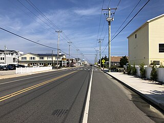
Surf City is a borough situated on the Jersey Shore in southern Ocean County, within the U.S. state of New Jersey. As of the 2020 United States census, the borough's population was 1,243, an increase of 38 (+3.2%) from the 2010 census count of 1,205, which in turn had reflected a decline of 237 (−16.4%) from the 1,442 counted in the 2000 census. The borough borders the Atlantic Ocean on Long Beach Island.

<span class="mw-page-title-main">Sandy Hook</span> Peninsula in New Jersey

Sandy Hook is a barrier spit in Middletown Township, Monmouth County, New Jersey, United States. The barrier spit, approximately 6 miles (9.7 km) in length and varying from 0.1 to 1.0 mile wide, is located at the north end of the Jersey Shore. It encloses the southern entrance of Lower New York Bay south of New York City, protecting it from the open waters of the Atlantic Ocean to the east.

<span class="mw-page-title-main">Long Beach Island</span> Barrier island in Ocean County, New Jersey, US

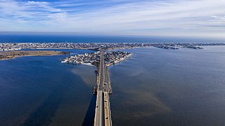
Long Beach Island is a barrier island and summer colony along the Atlantic Ocean coast of Ocean County, New Jersey, United States, on the Jersey Shore. Aligned north to south, the northern portion generally has more expensive low-density housing, whereas the southern portion possesses higher-density housing and considerable commercial development. Long Beach Island is 1-2 miles away from Mainland New Jersey. The primary industries include tourism, fishing, and real estate. The only access point to the island by land is a single causeway.

<span class="mw-page-title-main">Barnegat Peninsula</span>

The Barnegat Peninsula, also known as the Island Beach Peninsula or Barnegat Bay Island and colloquially as "the barrier island", is a 20-mile (32 km) long, narrow barrier peninsula located on the Jersey Shore in Ocean County, New Jersey, United States, that divides the Barnegat Bay from the Atlantic Ocean. It is a vacation destination and summer colony area and is heavily dependent on tourism, real estate and fishing. Notable communities on the peninsula include Point Pleasant Beach, Bay Head, Mantoloking, Lavallette, Ortley Beach, Seaside Heights, Seaside Park and the South Seaside Park section of Berkeley Township. The southern 10 miles (16 km) of the barrier island are preserved in their natural state as Island Beach State Park, New Jersey's longest stretch of undeveloped coastline.

<span class="mw-page-title-main">Barnegat Inlet</span>

Barnegat Inlet is a small inlet connecting the Barnegat Bay with the Atlantic Ocean in Ocean County, New Jersey. It separates Island Beach State Park and the Barnegat Peninsula from Long Beach Island. The Barnegat Lighthouse sits at the northern end of Long Beach Island along the inlet.

Loveladies is a neighborhood and unincorporated community located in the northernmost portion of Long Beach Township, in Ocean County, New Jersey, United States. The area is on Long Beach Island, between Barnegat Light and Harvey Cedars.

References

  1. https://www.njparksandforests.org/parks/islandbeachstatepark.html
  2. Island Beach Northern Natural Area and Southern Natural Area, accessed November 17, 2006
  3. New Jersey Birds: Island Beach State Park
  4. 1 2 "Christie spent night with his family in shuttered Island Beach State Park". Politico.com. July 2, 2017. Retrieved July 4, 2017.
  5. 1 2 3 Jennifer McDermott, Christie among the lucky few with state-owned vacation homes, Associated Press (July 3, 2017).
  6. Sharkey, Joe (August 26, 1995). "New Jersey Daily Briefing: Governor Gets the Ocean View". New York Times. Island Beach State Park, New Jersey.
  7. "The Governor's Getaway - StriperSurf Forums". Stripersurf.com. August 2, 2006. Retrieved July 4, 2017.
  8. "Archived copy" (PDF). oceanairsupportsquadron.camp8.org. Archived from the original (PDF) on February 2, 2017. Retrieved January 12, 2022.{{cite web}}: CS1 maint: archived copy as title (link)
  9. "What's in the governor's beach house? Auditor checks in". April 25, 2017.
  10. "Inside the Governor's Residence | www.mackinacislandnews.com | Mackinac Island Town Crier". www.mackinacislandnews.com. Archived from the original on October 1, 2014.
  11. "NC Governor's Mansion in Asheville". July 2, 2013.
  12. 1 2 "USDA Interactive Plant Hardiness Map". United States Department of Agriculture. Archived from the original on June 18, 2021. Retrieved July 7, 2020.
  13. "PRISM Climate Group, Oregon State University" . Retrieved July 7, 2020.
  14. "Water Temperature Table of All Coastal Regions" . Retrieved August 5, 2019.
  15. "U.S. Potential Natural Vegetation, Original Kuchler Types, v2.0 (Spatially Adjusted to Correct Geometric Distortions)" . Retrieved July 7, 2020.
  16. "Phenology Visualization Tool" . Retrieved July 7, 2020.
To the North:
Seaside Park
Beaches of New Jersey To the South
Barnegat Light