
The Passaic River is a river, approximately 80 mi (129 km) long, in northern New Jersey in the United States. The river in its upper course flows in a highly circuitous route, meandering through the swamp lowlands between the ridge hills of rural and suburban northern New Jersey, called the Great Swamp, draining much of the northern portion of the state through its tributaries. In its lower portion, it flows through the most urbanized and industrialized areas of the state, including along downtown Newark. The lower river suffered from severe pollution and industrial abandonment in the 20th century. In April 2014, the U.S. Environmental Protection Agency (EPA) announced a $1.7 billion plan to remove 4.3 million cubic yards of toxic mud from the bottom of lower eight miles of the river. It is considered one of the most polluted stretches of water in the nation and the project one of the largest clean-ups ever undertaken.
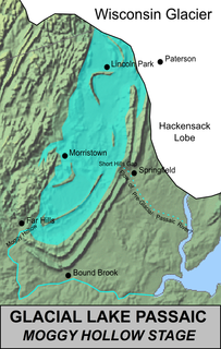
Lake Passaic was a prehistoric proglacial lake that existed in northern New Jersey in the United States at the end of the last ice age approximately 19,000–14,000 years ago. The lake was formed of waters released by the retreating Wisconsin Glacier, which had pushed large quantities of earth and rock ahead of its advance, blocking the previous natural drainage of the ancestral Passaic River through a gap in the central Watchung Mountains. The lake persisted for several thousand years as melting ice and eroding moraine dams slowly drained the former lake basin. The effect of the lake's creation permanently altered the course of the Passaic River, forcing it to take a circuitous route through the northern Watchung Mountains before spilling out into the lower piedmont.

The Pompton River is a tributary of the Passaic River, approximately 8 mi (13 km) long, in northern New Jersey in the United States.
The Rockaway River is a tributary of the Passaic River, approximately 35 mi (56 km) long, in northern New Jersey in the United States. The upper course of the river flows through a wooded mountainous valley, whereas the lower course flows through the populated New Jersey suburbs and former industrial area west of New York City. It drains an area of approximately 130 sq mi (340 km²).
The Whippany River is a tributary of the Rockaway River, approximately 20 mi (30 km) long, in northern New Jersey in the United States.
The Saddle River flows south through much of Bergen County, New Jersey. The river runs through densely populated suburban areas for much of its course. The river takes its name from the river near Saddell in Argyll and Bute in Scotland.
Spring Garden Brook is a tributary of the Passaic River in Morris County, New Jersey in the United States.
The South Branch Raritan River is a 50-mile-long (80 km) tributary of the Raritan River in central New Jersey in the United States.
The North Branch Raritan River is a tributary of the Raritan River in central New Jersey in the United States.

The Millstone River is a 38.6-mile-long (62.1 km) tributary of the Raritan River in central New Jersey in the United States.
Stevenson Brook is a tributary of the Passaic River in Hawthorne, Passaic County, New Jersey in the United States.
Little Diamond Brook is a tributary of the Passaic River which flows south through a section of Bergen County in New Jersey. Heading up the approximately two mile long brook from the Passaic River, one encounters the towns of Fair Lawn and Glen Rock.
Salt Brook is a tributary of the Passaic River in Union County, New Jersey in the United States.
Primrose Brook is a tributary of the Passaic River in the Jockey Hollow section of the Morristown National Historical Park of northern New Jersey in the United States.
Loantaka Brook is a tributary of the Passaic River in New Jersey in the United States.
The Lenape Trail is a trail connecting Newark, New Jersey with Roseland, New Jersey. It was established in 1982. It is the fifth longest trail in the state behind the Delaware and Raritan Canal Trail, the Appalachian Trail, the completed section of the Highlands Trail in the state and the Batona Trail. The Lenape trail traverses Newark and its suburbs, as well as the Watchung Mountains and Passaic Meadows. Because of the steepness of the Watchung Mountains and the flood-prone nature of the Passaic Meadows, the former basin of Glacial Lake Passaic, these areas have remained much less developed than the rest of the northeastern part of the state. This trail therefore offers hikers an opportunity to see cultural and historical sites of an urban trail, as well as large natural and undeveloped areas. The trail's proximity to New York City and the various ridges it traverses, including Forest Hill, Orange Mountain, and Second Watchung Mountain, offer many views of the skyline. The Lenape Trail forms a segment of the Liberty-Water Gap Trail and incorporates the West Essex Trail, the Lenape Trail's only rail-to-trail section. The Lenape Trail also connects with Morris County's Patriots Path trail system on its western terminus.

Goffle Hill, also referred to as Goffle Mountain and historically known as Totoway Mountain and Wagaraw Mountain, is a range of the trap rock Watchung Mountains on the western edge of the Newark Basin in northern New Jersey. The hill straddles part of the border of Bergen County and Passaic County, underlying a mostly suburban setting. While hosting patches of woodlands, perched wetlands, and traprock glades, the hill is largely unprotected from development. Extensive quarrying for trap rock has obliterated large tracts of the hill in North Haledon, and Prospect Park. Conservation efforts seeking to preserve undeveloped land, such as the local Save the Woods initiative (2007–present), are ongoing.

Oakeys Brook is a tributary of Lawrence Brook, a branch of the Raritan River in Middlesex County, New Jersey in the United States.
Weasel Brook is a tributary of the Passaic River in Passaic County, New Jersey, United States. Weasel Brook flows through Clifton and through Weasel Brook Park.

Passaic River Parkway, often called Passaic River Park, is a linear park along the banks of the Passaic River in Union County, New Jersey. It is one of the three "emerald necklaces" in the Union County Park System, the others being Rahway River Parkway and Elizabeth River Parkway.
