Bergen County is the most populous county in the U.S. state of New Jersey. As of the 2020 United States Census, the county's population was 955,732, an increase of 50,616 (5.6%) from the 905,116 residents enumerated in the 2010 census by the United States Census Bureau, which in turn represented an increase of 20,998 (2.4%) from the 884,118 counted in the 2000 Census. Located in the northeastern corner of New Jersey and its Gateway Region, Bergen County is part of the New York City metropolitan area and is directly across the Hudson River from Manhattan, to which it is connected by the George Washington Bridge.
Route 17 is a state highway in Bergen County, New Jersey, United States, that provides a major route from the George Washington Bridge, Lincoln Tunnel and other northeast New Jersey points to the New York State Thruway at Suffern, New York. It runs 27.20 mi (43.77 km) from an intersection with Route 7 and County Route 507 (CR 507) in North Arlington north to the New York border along Interstate 287 (I-287) in Mahwah, where New York State Route 17 (NY 17) continues into New York. Between Route 7 and Route 3 in Rutherford, Route 17 serves as a local road. From Route 3 north to the junction with U.S. Route 46 (US 46) in Hasbrouck Heights, the road is a suburban arterial with jughandles. The portion of Route 17 from US 46 to I-287 near the state line in Mahwah is a limited-access road with all cross traffic handled by interchanges, and many driveways and side streets accessed from right-in/right-out ramps from the right lane. For three miles (5 km) north of Route 4, well over a hundred retail stores and several large shopping malls line the route in the borough of Paramus. The remainder of this portion of Route 17 features lighter suburban development. The northernmost portion of Route 17 in Mahwah runs concurrently with I-287 to the New York border.

Saddle Brook is a township in Bergen County, New Jersey, United States. As of the 2010 United States Census, the township's population was 13,659, reflecting an increase of 504 (+3.8%) from the 13,155 counted in the 2000 Census, which had in turn declined by 141 (-1.1%) from the 13,296 counted in the 1990 Census.

Ho-Ho-Kus is a borough in Bergen County, New Jersey, United States. As of the 2010 census, the borough's population was 4,078, reflecting an increase of 18 (+0.4%) from the 4,060 counted in the 2000 Census, which had in turn increased by 125 (+3.2%) from the 3,935 counted in the 1990 Census. The borough is the home of several historical landmarks, including the Ho-Ho-Kus Inn and The Hermitage.

The Passaic River is a river, approximately 80 mi (129 km) long, in northern New Jersey in the United States. The river in its upper course flows in a highly circuitous route, meandering through the swamp lowlands between the ridge hills of rural and suburban northern New Jersey, called the Great Swamp, draining much of the northern portion of the state through its tributaries. In its lower portion, it flows through the most urbanized and industrialized areas of the state, including along downtown Newark. The lower river suffered from severe pollution and industrial abandonment in the 20th century. In April 2014, the U.S. Environmental Protection Agency (EPA) announced a $1.7 billion plan to remove 4.3 million cubic yards of toxic mud from the bottom of lower eight miles (13 km) of the river. It is considered one of the most polluted stretches of water in the nation and the project one of the largest clean-ups ever undertaken.

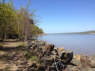
The Hackensack River is a river, approximately 45 miles (72 km) long, in the U.S. states of New York and New Jersey, emptying into Newark Bay, a back chamber of New York Harbor. The watershed of the river includes part of the suburban area outside New York City just west of the lower Hudson River, which it roughly parallels, separated from it by the New Jersey Palisades. It also flows through and drains the New Jersey Meadowlands. The lower river, which is navigable as far as the city of Hackensack, is heavily industrialized and forms a commercial extension of Newark Bay. Once believed to be among the most polluted watercourses in the United States, it staged a modest revival by the late 2000s.

The Main Line is a commuter rail line owned and operated by New Jersey Transit running from Suffern, New York to Hoboken, New Jersey, in the United States. It runs daily commuter service and was once the north–south main line of the Erie Railroad. It is colored yellow on NJ Transit system maps, and its symbol is a water wheel.

The Bergen County Line is a commuter rail line and service owned and operated by New Jersey Transit in the U.S. state of New Jersey. The line loops off the Main Line between the Meadowlands and Glen Rock, with trains continuing in either direction along the Main Line. It is colored on NJT system maps in grey, and its symbol is a cattail, which are commonly found in the Meadowlands where the line runs.
Midland Park Jr./Sr. High School is a six-year comprehensive public high school for students in seventh through twelfth grades in Midland Park, in Bergen County, New Jersey, United States. Opened in 1957, it is a junior-senior high school operating as the lone secondary school of the Midland Park School District.
Ho-Ho-Kus Brook is a tributary of the Saddle River in Bergen County, New Jersey, in the United States.

New Jersey's 5th congressional district is represented by Democrat Josh Gottheimer, who has served in Congress since 2017.

Goffle Brook is a tributary of the Passaic River which flows south through a section of Passaic County and Bergen County in New Jersey and drains the eastern side of the First Watchung Mountain. Heading up the brook from the confluence with the Passaic River, one encounters the borough of Hawthorne, the village of Ridgewood, the borough of Midland Park, and the township of Wyckoff.

Diamond Brook, also known as Bass Brook, is a tributary of the Passaic River which flows south through a section of Bergen County in New Jersey, United States. Heading up the brook from the Passaic River, one encounters the boroughs of Fair Lawn and Glen Rock, as well as the village of Ridgewood.
Orvil Township was a township that existed in Bergen County, New Jersey, United States, from 1886 to 1919.
County Route 507 is a county highway in the U.S. state of New Jersey. The highway extends 28.37 mi (45.66 km) from Harrison Avenue on the Kearny-Harrison town line to the New York state line in Mahwah. Between Ho-Ho-Kus and Mahwah, this highway is known as Franklin Turnpike. At its northern terminus, County Route 507 continues north into New York as Orange Avenue, which is a portion of U.S. Route 202 (US 202).

Saddle River County Park is a 596-acre (2.41 km2) county park in Bergen County, New Jersey, United States, stretching from Ridgewood to Rochelle Park, and extends out to Glen Rock. The park is located along the Saddle River and consists of five sections, all of which are connected by a paved path that is open to both pedestrians and bicyclists.
Ackerman House may refer to:
