Canso is a Martian crater. It lies about 450 kilometres west of the Viking 1 lander, slightly northeast of Lunae Planum, and west of Chryse Planitia, in the Lunae Palus quadrangle. The crater is named after Canso, a fishing town in Nova Scotia. The name was officially adopted in 1988 by the International Astronomical Union's Working Group for Planetary System Nomenclature (IAU/WGPSN).

Fahrenheit is a tiny lunar impact crater located in the southeast part of the Mare Crisium. This area of the surface is nearly devoid of impact features of interest. To the east are the Dorsa Harker wrinkle ridges, and beyond them is Promontorium Agarum at the edge of the mare. The landing site of the Soviet Luna 24 probe is located about 15 kilometers to the southeast.

Al-Marrakushi is a small, relatively isolated lunar impact crater in the eastern Mare Fecunditatis. It is a circular, symmetrical formation, with inner walls that slope down to the midpoint. To the northeast is the prominent crater Langrenus. The mare near Al-Marrakushi is marked by ray material from its larger neighbor.

Born is a small lunar impact crater located near the eastern edge of the Moon, to the northeast of the prominent crater Langrenus. It was previously designated Maclaurin Y before being named by the IAU in 1979. Maclaurin itself lies to the north.

Artamonov is a lunar impact crater that is located on the far side of the Moon. The eroded outer rim of Artamonov does not have the circular shape of most lunar craters, and instead has the overall shape of three or four merged craters. The largest of these formations is in the south, with smaller circular bulges to the north and east.

Barkla is a lunar impact crater that lies near the eastern limb of the Moon. It is located to the east of the prominent crater Langrenus, and was formerly designated Langrenus A before being renamed by the IAU in 1979. Due east of Barkla is Kapteyn, a formation only slightly larger with a similar size. Southwest of Barkla is the crater Lamé.

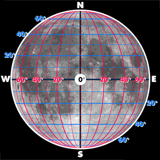
Montes Alpes is a mountain range in the northern part of the Moon's near side. It was named after the Alps in Europe; the name was confirmed by the International Astronomical Union in 1935. It lies between the selenographic coordinates latitudes 52.81°N and 42.04°N, and longitudes 5.6°W and 3.22°E. The range thus crosses the lunar prime meridian, and is partially illuminated and partially in shadow during first and last quarters. The center of the range is at 48.36°N, 0.58°W, and has a diameter of 334 km.

Damoiseau is a lunar impact crater that is located just to the west of the Oceanus Procellarum, in the western part of the Moon's near side. It lies due east of the prominent crater Grimaldi, a walled plain with a distinctive dark floor. Due south of Damoiseau is the crater Sirsalis.

Dollond is a small lunar impact crater that is located in the central region of the Moon, to the north of the crater Abulfeda. It was named after British optician John Dollond. Due west of Dollond is Anděl. Dollond is circular and cone shaped, with a tiny floor at the midpoint of the sloping interior walls.

Mons Hadley is a massif in the northern portion of the Montes Apenninus, a range in the northern hemisphere of the Moon. It has a height of 4.2 km (14,000 ft) above the adjacent plain and a maximum diameter of 25 km at the base.

Sinus Iridum is a plain of basaltic lava that forms a northwestern extension to the Mare Imbrium on Earth's moon. It is surrounded from the northeast to the southwest by the Montes Jura range. The protruding part of the range at the southwest end is named Promontorium Heraclides, while that at the northeast end is called Promontorium Laplace. This bay and the surrounding mountains is considered one of the most beautiful features on the Moon, and is a favorite among lunar observers.

Cassini is a lunar impact crater that is located in the Palus Nebularum, at the eastern end of Mare Imbrium. The crater was named after astronomers Giovanni Cassini and Jacques Cassini. To the northeast is the Promontorium Agassiz, the southern tip of the Montes Alpes mountain range. South by south-east of Cassini is the crater Theaetetus. To the northwest is the lone peak Mons Piton.

Lacus Oblivionis is a small lunar mare on the surface of the Moon. It is located at 21.0° S, 168.0° W and is 50 km in diameter. The name was adopted by the IAU in 1976.

Rupes Kelvin is an escarpment near Promontorium Kelvin on the near side of the Moon, at 27.3°S 33.1°W. It is 86 km long. It takes its name from Promontorium Kelvin, which was named after the Irish scientist, physicist and engineer William Thomson, 1st Baron Kelvin.
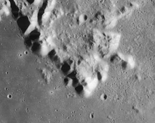
Promontorium Laplace is a raised mountainous cape situated at the end of Montes Jura in Mare Imbrium on the near side of the Moon. Its selenographic coordinates are 46.8° N, 25.5° W and it is 2600 meters high. It forms the northeast boundary of the bay of Sinus Iridum.
Mons Usov is a small lunar mountain that is located in the southeastern part of the Mare Crisium, to the north of the crater Firmicus, west of Concorcet crater, and northwest of Promontorium Agarum. It is essentially a part of the mountainous rim of the Crisium basin but appears somewhat isolated because of flooding of the basin by mare basalt.

Darwin is an impact crater on Mars, located at 57°S 19°E to the southeast of Argyre Planitia in Noachis Terra. It is approximately 176 km in diameter. The crater's name was formally approved by the IAU in 1973.
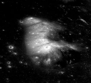
Promontorium Agassiz is a mountainous cape situated on the northeast margin of Mare Imbrium on the near side of the Moon. Its selenographic coordinates are 42.4° N, 1.77° E. It is located south of Promontorium Deville and Mons Blanc, northeast of Mons Piton, and northwest of Cassini crater.