A promontory is a prominent mass of land which overlooks lower lying land or a body of water.
Contents
Promontory may also refer to:
A promontory is a prominent mass of land which overlooks lower lying land or a body of water.
Promontory may also refer to:

Box Elder County is a county at the northwestern corner of Utah, United States. At the 2020 census, the population was 57,666, up from the 2010 figure of 49,975. Its county seat and largest city is Brigham City. The county was named for the box elder trees that abound in the county.

Howell is a town located in the Blue Creek Valley in northeast Box Elder County, Utah, United States. The population was 245 at the 2010 census.

Promontory Point is the promontory or southernmost point of the peninsula formed where the Promontory Mountains project into the northern Great Salt Lake in southeastern Box Elder County, Utah, United States.
Promontory Point may refer to:

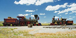
Promontory is an area of high ground in Box Elder County, Utah, United States, 32 mi (51 km) west of Brigham City and 66 mi (106 km) northwest of Salt Lake City. Rising to an elevation of 4,902 feet (1,494 m) above sea level, it lies to the north of the Promontory Mountains and the Great Salt Lake. It is notable as the location of Promontory Summit, where the First transcontinental railroad from Sacramento to Omaha in the United States was officially completed on May 10, 1869. The location is sometimes confused with Promontory Point, a location further south along the southern tip of the Promontory Mountains. Both locations are significant to the Overland Route: Promontory Summit was where the original, now abandoned, alignment crossed just north of the Promontory Mountains; while Promontory Point is where the modern alignment, called the Lucin Cutoff, crosses the southern tip of the Promontory Mountains.

Golden Spike National Historical Park is a United States National Historical Park located at Promontory Summit, north of the Great Salt Lake in east-central Box Elder County, Utah, United States. The nearest city is Corinne, approximately 23 miles (37 km) east-southeast of the site.
Cedar Hills may refer to:
The Notch may refer to:

Terrace is a ghost town in the Great Salt Lake Desert in west-central Box Elder County, Utah, United States.
Crystal Peak may refer to:

Utah State Route 3 may refer to:

Utah State Route 85 may refer to:

The Promontory Mountains are a range in Box Elder County, Utah. The range is oriented north–south and has a length of about 35 miles (56 km). The southern portion forms a cape extending 20 miles (32 km) south into the Great Salt Lake. The First transcontinental railroad was completed with the Golden Spike just north of the range at Promontory Summit in the Utah Territory. Today, trains cross the Promontory Point at the southern tip of the range via the Lucin Cutoff railroad causeway across the lake.

State Route 83 (SR-83) is a 30.726-mile (49.449 km) state highway in eastern Box Elder County, Utah, United States, that connects the towns of Corinne and Howell and provides access to Golden Spike National Historic Site from the east, as well as Thiokol's facility.

The Raft River Mountains are a mountain range in northern Box Elder County, Utah, United States. The mountains are located in the Raft River Division of the Minidoka Ranger District of the Sawtooth National Forest. The highest point is Bull Mountain, near the Dunn Benchmark, at 9,925 ft (3,025 m), and the ghost town of Yost is on the north-central slopes. Tributaries of the Raft River drain the northern slopes of the range to the Snake River then Columbia River and Pacific Ocean, while the southern slopes drain to the Great Salt Lake.
Mountain States Telephone and Telegraph Building or variations may refer to:

The Black Pine Mountains are a mountain range in the U.S. states of Idaho (~65%) and Utah (~35%), spanning Cassia County, Idaho and reaching into Box Elder County, Utah. The highest point in the range is known as Black Pine Mountains High Point, sometimes referred to as Black Peak, at 9,395 feet (2,864 m), and the range is a part of the Great Basin Divide and the Basin and Range Province. In Idaho, the mountains are part of the Black Pine Division of the Minidoka Ranger District of Sawtooth National Forest.

Utah State Route 38 may refer to:
Promontory Point is a ghost town in Box Elder County, Utah, United States, that is located about 1.7 miles (2.7 km) northeast of the cape with the same name.