
Ólafsfjörður is a town in the northeast of Iceland located at the mouth of the fjord Eyjafjörður.

Bernardino Bilbao is a province in the Northern parts of the Bolivian department of Potosí. It has its name after Bernardino Bilbao Rioja, Bolivian general and politician.

Karimama is a town, arrondissement and commune in the Alibori Department of northeastern Benin. The commune covers an area of 6102 square kilometers and as of 2013 had a population of 66,675 people. The town lies on the border with Niger.
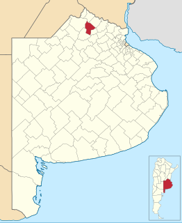
Arrecifes Partido is a partido in the north-east of Buenos Aires Province in Argentina. It is at coordinates 34°04′S60°07′W.
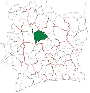
Mankono Department is a department of Béré Region in Woroba District, Ivory Coast. In 2014, its population was 215,500 and its seat is the settlement of Mankono. The sub-prefectures of the department are Bouandougou, Mankono, Marandallah, Sarhala, and Tiéningboué.

Lawrie Glacier is a glacier flowing between Mount Genecand and Mezzo Buttress, and entering the head of Barilari Bay between Cherkovna Point and Prestoy Point on the west coast of Graham Land, Antarctica. It was charted by the British Graham Land Expedition under Rymill, 1934–37, and was named by the UK Antarctic Place-Names Committee in 1959 for Robert Lawrie, an English alpine and polar equipment specialist.

Göydərə is a village in the Kalbajar District of Azerbaijan.

Boydell Glacier is a glacier on Trinity Peninsula in northern Graham Land. It is about 9 miles (14 km) long, flowing southeastward from Detroit Plateau to enter Sjögren Inlet in Prince Gustav Channel north of the terminus of Sjögren Glacier and 6 miles (10 km) west of Mount Wild. It was mapped by the Falkland Islands Dependencies Survey from surveys (1960–61), and named by the UK Antarctic Place-Names Committee for James Boydell, English inventor of a steam traction engine, the first practical track-laying vehicle.
Caulfeild Glacier is the northern of two glaciers flowing into Hugi Glacier west of Dodunekov Peak, on the west coast of Graham Land.
Weir Glacier is a glacier 8 nautical miles (15 km) long, flowing north into the south part of Barilari Bay between Prestoy Point and Byaga Point, on the west coast of Graham Land. First sighted and roughly charted in 1909 by the French Antarctic Expedition under Charcot. It was surveyed in 1935-36 by the British Graham Land Expedition (BGLE) under Rymill and later named for William D. Weir, 1st Viscount Weir of Eastwood, and his son, the Hon. James K. Weir, who contributed toward the cost of the BGLE, 1934–37.
Mount Crow is a mountain just east of Mount McClung in the Ford Ranges of Marie Byrd Land. It was discovered and mapped by the United States Antarctic Service (1939–41), and named by the Advisory Committee on Antarctic Names for Lieutenant J.L. Crow, MC, U.S. Navy, officer in charge at Byrd Station, 1963.
The Kraut Rocks are a group of rock outcrops on the snow-covered, lower southwest slopes of the Mount Berlin massif, in Marie Byrd Land, Antarctica. They were mapped by the United States Geological Survey from surveys and U.S. Navy air photos, 1959–66, and were named by the Advisory Committee on Antarctic Names for William F. Kraut, U.S. Navy, a radioman with the 1956 Army Navy Trail Party that traversed eastward from Little America V to establish Byrd Station.
Philbin Inlet is a narrow, ice-filled inlet about 15 nautical miles (28 km) long that indents the north end of Martin Peninsula between Murray Foreland and Slichter Foreland, on Walgreen Coast, Marie Byrd Land. First mapped by United States Geological Survey (USGS) from air photos taken by U.S. Navy Operation Highjump in January 1947. Named by Advisory Committee on Antarctic Names (US-ACAN) after Brigadier General Tobias "Toby" Philbin, USA, who served the Secretary of Defense in liaison with the U.S. Navy during the 1957-58 IGY.
Hugi Glacier is a glacier flowing northward into the head of Holtedahl Bay southwest of Rasnik Peak, on the west coast of Graham Land, Antarctica. It was charted by the British Graham Land Expedition under John Rymill, 1934–37, and was named by the UK Antarctic Place-Names Committee in 1959 for Franz Joseph Hugi, a Swiss teacher who was called the "father of winter mountaineering," and was author of two pioneer works on glacier phenomena.

Hoek Glacier is a glacier flowing into Dimitrov Cove northeast of Veshka Point on the northwest coast of Velingrad Peninsula on Graham Coast in Graham Land, Antarctica, southward of the Llanquihue Islands. It was charted by the British Graham Land Expedition under John Rymill, 1934–37, and was named by the UK Antarctic Place-Names Committee in 1959 for Henry W. Hoek (1878–1951), a pioneer Swiss ski-mountaineer and author of one of the earliest skiing manuals.
Mount Machatschek is a prominent, mainly snow-covered mountain in northern Adelaide Island, Antarctica, about 14 nautical miles (26 km) southwest of Mount Velain. It was mapped from air photos taken by the Ronne Antarctic Research Expedition (1947–48) and the Falkland Islands and Dependencies Aerial Survey Expedition (1956–57), and was named by the UK Antarctic Place-Names Committee after Austrian geomorphologist Fritz Machatschek (1876–1957), who was the joint author with Erich von Drygalski of Gletscherkunde, 1942.

Sölch Glacier is a glacier on the Pernik Peninsula of the Loubet Coast in Graham Land, flowing west to Salmon Cove just north of Kanchov Peak on the east side of Lallemand Fjord. It was mapped from air photos taken by the Falkland Islands and Dependencies Aerial Survey Expedition, 1956–57, and named by United Kingdom Antarctic Place-Names Committee for Johann Sölch (1883–1951), an Austrian glacial geologist and glaciologist.
Bacteridium bermudense is a species of sea snail, a marine gastropod mollusk in the family Pyramidellidae, the pyrams and their allies. The species remains within the Bacteridium genus of gastropods, with the exception of the other three related species being Bacteridium carinatum, Bacteridium resticulum and Bacteridium vittatum.
