Maps
 |  |
The Purchase Line is the name commonly given to the line dividing Indian from British Colonial lands established in the Treaty of Fort Stanwix of 1768 in western Pennsylvania. In New York State documents, it is referred to as the Line of Property. That article contains the treaty text and other sections.
The relevant section of the treaty reads:
This line was not clearly defined until in a meeting between Indian and Pennsylvania representatives in 1773 at the well-known "Canoe Place" or upper limit of canoe navigation on the Susquehanna at its confluence with Cush Cushion Creek at present-day Cherry Tree, Pennsylvania. This was agreed to as the "nearest point" of the treaty. This became the tri-point between present-day Clearfield, Cambria, and Indiana counties, although the borough of Cherry Tree, Pennsylvania was later included entirely in Indiana for convenience.
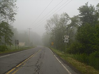
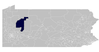
The line is still a boundary through most of its length: in Armstrong County running ESE from Kittanning it separates the townships of Rayburn and Valley (north) from Manor and Kittanning (south). There is gap through the town of Cowanshannock, but at the knick point of the boundary between Armstrong County and Indiana County the line begins again, separating the Indiana County townships of South Mahoning, East Mahoning, Grant and Montgomery (north) from Washington, Rayne and Green (south). The hamlet of Purchase Line is on PA 286 in Green township just south of the actual line.
| | |

Armstrong County is a county in the Commonwealth of Pennsylvania. As of the 2020 census, the population was 65,558. The county seat is Kittanning. The county was organized on March 12, 1800, from parts of Allegheny, Westmoreland and Lycoming Counties. It was named in honor of John Armstrong, who represented Pennsylvania in the Continental Congress and served as a major general during the Revolutionary War.

Jefferson County is a county in the Commonwealth of Pennsylvania. As of the 2020 census, the population was 44,492. Its county seat is Brookville. The county was established on March 26, 1804, from part of Lycoming County and later organized in 1830. It is named for President Thomas Jefferson. It is home to Punxsutawney Phil, the most famous groundhog that predicts when spring will come every February 2 on Groundhog Day. The county is part of the North Central Pennsylvania region of the state.

Indiana County is a county in the Commonwealth of Pennsylvania. It is located in the west central part of Pennsylvania. As of the 2020 census, the population was 83,246. Its county seat is Indiana. Indiana County comprises the Indiana, PA Micropolitan Statistical Area, which is also included in the Pittsburgh-New Castle-Weirton, PA-WV-OH Combined Statistical Area. The county is part of the Southwest Pennsylvania region of the state.

Mahoning Township is a township in Armstrong County, Pennsylvania, United States. The population was 1,406 at the 2020 census, a decrease from 1,425 at the 2010 census.

West Franklin Township is a township in Armstrong County, Pennsylvania, United States. The population was 1,709 at the 2020 census, a decline from the figure of 1,853 tabulated in 2010.
Susquehanna Township is a township in Cambria County, Pennsylvania, United States. The population was 2,007 at the 2010 census. It is part of the Johnstown, Pennsylvania Metropolitan Statistical Area.
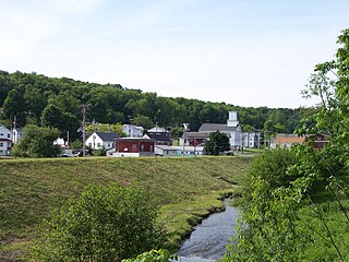
Cherry Tree is a borough in Indiana County, Pennsylvania, United States. The population was 276 at the 2020 census.

The Kittanning Path was a major east-west Native American trail that crossed the Allegheny Mountains barrier ridge connecting the Susquehanna River valleys in the center of Pennsylvania to the highlands of the Appalachian Plateau and thence to the western lands beyond drained by the Ohio River. Kittanning Village was the first major Delaware (Lenape) Indian settlement along the descent from the Allegheny Plateau.

The Line of Property is the name commonly given to the line dividing Indian lands from those of the Thirteen Colonies, which were established in the 1768 Treaty of Fort Stanwix between British officials and the Iroquois tribes. In western Pennsylvania, it is referred to as the Purchase line.
Loop was an unincorporated community in West Mahoning Township, Indiana County, Pennsylvania. It was named for being near a loop-like meander of Mahoning Creek. Lysander Barrett settled in the area around 1842; an iron furnace was erected in 1847. Before its eventual abandonment, the community had a post office, a schoolhouse, and a stop on the Buffalo, Rochester and Pittsburgh Railway.

The Mahoning Valley is a geographic valley encompassing Northeast Ohio and a small portion of Western Pennsylvania that drains into the Mahoning River. According to information at the bottom of Page 321 in a publication by the Ohio Secretary of State's Office, the river name comes from an Indian word meaning “at the licks.”
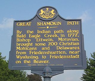
The Great Shamokin Path was a major Native American trail in the U.S. State of Pennsylvania that ran from the native village of Shamokin along the left bank of the West Branch Susquehanna River north and then west to the Great Island. There it left the river and continued further west to Chinklacamoose and finally Kittanning on the Allegheny River.

Locust is an unincorporated community located in North Mahoning Township, Indiana County, Pennsylvania, United States.
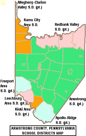
The Armstrong School District is a large, public school district which encompasses approximately 437 square miles (1,130 km2). The district is one of the 500 public school districts of Pennsylvania. In Armstrong County, Pennsylvania, Armstrong School District covers the Boroughs of Applewold, Atwood, Dayton, Elderton, Ford City, Ford Cliff, Kittanning, Manorville, Rural Valley, West Kittanning and Worthington and the Townships of Bethel Township, Boggs Township, Burrell Township, Cadogan Township, Cowanshannock Township, East Franklin Township, Kittanning Township, Manor Township, North Buffalo Township, Pine Township, Plumcreek Township, Rayburn Township, South Bend Township, Valley Township, Washington Township, Wayne Township and West Franklin Township. In Indiana County, Pennsylvania, the district includes the Borough of Smicksburg and West Mahoning Township. According to 2000 federal census data, it served a resident population of 44,970. By 2010, the District's population had declined to 43,301 people. In 2009, Armstrong School District residents' per capita income was $15,449, while the median family income was $36,907.
The 63rd Pennsylvania House of Representatives District is in Western Pennsylvania and has been represented by Donna Oberlander since 2009.

The 66th Pennsylvania House of Representatives District is located in west central Pennsylvania and has been represented by Brian Smith since 2021.

The Judge J. Frank Graff Bridge is an American truss bridge that carries U.S. Route 422 (US 422) and Pennsylvania Route 28 (PA 28) across the Allegheny River. It was named in honor of Frank Graff, an Armstrong County Court of Common Pleas Judge who later rose to become a member of the Pennsylvania Superior Court.

The Mahoning Creek Dam is a dam in Armstrong County, Pennsylvania.
Sechler Run is a tributary of Mahoning Creek in Montour County, Pennsylvania, in the United States. It is 4.63 miles (7.45 km) long. The stream flows through Cooper Township, Mahoning Township, and Danville. Its only named tributary is Blizzards Run.

The Pennsylvania Wilds, or the Pennsylvania Wilds Conservation Landscape, is a predominantly rural and forested region in northern central Pennsylvania, mostly within the Allegheny Plateau. It covers about a quarter of the state's territory, but is home to only 4% of its population. It is one of Pennsylvania's 11 state-designated tourist regions.