
Vaughan is a city in Ontario, Canada. It is located in the Regional Municipality of York, just north of Toronto. Vaughan was the fastest-growing municipality in Canada between 1996 and 2006, achieving a population growth rate of 80.2% according to Statistics Canada and having nearly doubled in population since 1991. It is the fifth-largest city in the Greater Toronto Area, and the 17th-largest city in Canada.

Kortright Centre for Conservation, or simply Kortright Centre, is a suburban conservation area in Vaughan, Ontario, Canada in the northern part of the Greater Toronto Area. It is between Rutherford Road to the south and Major Mackenzie Drive to the north. It is located 38 km northwest of downtown Toronto, about 4 km west of Highway 400. The area in which it is located is predominantly forested in its western and northern extent. The Humber River is situated in the west and the Cold Creek and Harris Creek are to the north.

Maple is a high-growth suburban community, part of the city of Vaughan, Ontario in York Region, northwest of Toronto, Ontario. As an unincorporated area, it does not have clearly defined geographic boundaries, but it grew around the former village of Maple, centred at the intersection of Major Mackenzie Drive and Keele Street in Vaughan.

Sheppard Avenue is an east–west principal arterial road in Toronto, Ontario, Canada. The street has two distinct branches near its eastern end, with the original route being a collector road leading to Pickering via a turnoff, and the main route following a later-built roadway which runs south to Kingston Road. To avoid name duplication, the Toronto portion of the northern branch was renamed Twyn Rivers Drive. The section of the street entirely in Toronto is (34.2 km) in length, while the Pickering section and Twyn Rivers Dr. is (5.4 km) long.

Kipling Avenue, is a street in the Cities of Toronto and Vaughan in Ontario, Canada. It is a concession road, 6 concessions (12 km) from Yonge Street, and is a major north–south arterial road. It consists of three separate sections, with total combined length of 26.4 km. (16.4 mi.).
Vaughan Mills Terminal is a transit terminal in York Region, Ontario, Canada, at 1 Bass Pro Mills Drive, near the northeast corridor of Vaughan Mills and the intersection of Rutherford Road and Jane Street in Vaughan, Ontario. As of 2017, oneRide ticket machines is installed at this terminal.

Victoria Village, sometimes referred to as Sloane, is a neighbourhood in the city of Toronto, Ontario, Canada bounded on the west by the Don Valley, on the north by Lawrence Avenue East, on the east by Victoria Park Avenue, and on the south by Eglinton Avenue East, although there is a small area south of Eglinton to Sunrise Avenue that is sometimes included. It is located in the southeast of the former city of North York. Its population is diverse in ancestral backgrounds with a larger proportion of South Americans than most of the city.
Teston is a suburban neighbourhood and former hamlet located at the intersection of Teston Road and Jane Street, in the City of Vaughan, Ontario, at the northern edge of the city's developed area. The Teston United Church and some homes of early settlers are still standing to this day, but the rapid development of Vaughan has impacted the area in recent years.

Toronto Gore was a township in Ontario, Canada. It is today split between Mississauga and Brampton.

Pine Point Park is a park in Toronto, Ontario, located on the east end junction of Allenby Avenue and Hadrian Drive, near the intersection of Highway 401 and Islington Avenue. The park itself is bordered by Albion Road to the west, Highway 401 to the south, and Humber River to the east.
Vaughan Road is a road in Toronto, Ontario, Canada. It is a contour collector road that is parallel to a buried creek to the north called Castle Frank Brook. Vaughan Road begins on Bathurst Street south of St. Clair Avenue West, then it becomes a north-south street, hence its address numbering system, then it becomes a northwest-southeast street. Finally, Vaughan Road ends in a dead-end near the intersection of Eglinton Avenue and Dufferin Street. Vaughan Road Academy is named after this road.
Cashel, Ontario is a small hamlet situated in Unionville, Ontario located at the intersection of Elgin Mills Road and York Regional Road 67. Originally it was called Crosby Corners after John Crosby, the village's first store owner, who came originally from New York State. The name was changed to Cashel in 1851 with the opening of its first post office. It was likely named after Cashel in Ireland. In 1851 the community had a sawmill, cobbler shop, blacksmith shop, wagon shop, inn and tavern, Masonic Lodge, and Presbyterian church. In 1890 Peaches United Church was built on land from farmer Thomas Peach at 10762 McCowan Road. The church is a historic site and not operating since the 1960s to 1970s, but cemetery remains in active use.

Mount Carmel is a primarily residential hamlet located in southwestern Ontario, Canada.
Hope is the northernmost community in the city of Vaughan, in Ontario, Canada. The community is mostly rural, with farms scattered along the major thoroughfare. The heart of the settlement is at Keele Street and Kirby Road, with its eastern side stretching as far as Bathurst Street.
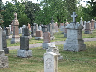
St. John's Norway Cemetery and Crematorium is an historic cemetery in Toronto, Ontario, Canada. It is located at the intersection of Kingston Road and Woodbine Avenue in the east end of the city just northwest of The Beaches neighbourhood.
Brougham is a community within the northern part of the City of Pickering, in Durham Region of Ontario, Canada. Some of its lands are affected by plans to build the proposed Pickering Airport. There are concerns because some of its buildings are of architectural significance. There is one bus in the area; the 52 York University passes through with a stop at Brock Road. The population is about 150. The children go to school at Valley View Public School in its neighbouring town of Greenwood. It has slowly reduced in population and business as the 407 wound its way through in the early 2000s. It currently houses an Antique Restoration, Pickering Animal Shelter, Hot Tub Outlet and RV dealership, as well as a handful of historical buildings dating back to the Mackenzie Rebellion. In the past, the hamlet has been home for a Mac's Milk as well as a Family Run Hardware Store, a small restaurant as well as a small mechanic shop, most of which closed down in or around the time that the plans for the 407 development came to realization.

Highland Creek is a river in the Scarborough district of Toronto, Ontario, emptying into Lake Ontario at the eastern end of the Scarborough Bluffs. It is home to several species of fish including trout, carp, bass and salmon. It is a meandering river which, like most rivers in Toronto, travels through a glacial ravine formed after the last Ice Age. The Highland Creek watershed, including tributaries, is almost entirely contained within Scarborough.
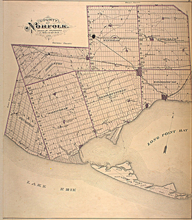
Norfolk County in the Canadian province of Ontario consists of a long list of communities. Its four designated population centres are Simcoe, Port Dover, Delhi, and Waterford.
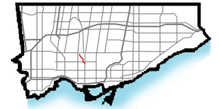
King—Vaughan is a federal electoral district in Ontario, Canada.
Tommy Douglas Secondary School (TDSS) is a secondary education facility in Woodbridge, Ontario, Canada that opened on 3 February 2015. It is named after Tommy Douglas, the seventh Premier of Saskatchewan whose government implemented North America's first single-payer, universal health care program. It is a secular public school administered by the York Region District School Board. The school is located at 4020 Major Mackenzie Drive, and its first and current principal is Ann Pace. The school day runs from 8:10 to 2:25.


