
Tsing Yi, sometimes referred to as Tsing Yi Island, is an island in the urban area of Hong Kong, to the northwest of Hong Kong Island and south of Tsuen Wan. With an area of 10.69 km², the island has extended drastically by reclamation along almost all its natural shore and the annexation of Nga Ying Chau (牙鷹洲) and Chau Tsai. Three major bays or harbours, Tsing Yi Lagoon, Mun Tsai Tong and Tsing Yi Bay (青衣灣) in the northeast, have been completely reclaimed for new towns.

Rambler Channel is a body of water in Hong Kong that separates Tsing Yi Island from Tsuen Wan and Kwai Chung in the New Territories. The channel separates the two landmasses by 900 metres at its widest point.
Tsing Yi Lagoon, or Tsing Yi Tong, was a lagoon on the east shore of Tsing Yi Island in Hong Kong. Its water came from a stream in the nearby valley of Liu To and its outlet was at Tsing Yi Bay. It acted as the shelter for nearby boat people, especially after large-scale land reclamation in Tsuen Wan and Kwai Chung. Once their boats moved into the lagoon, they never moved out. This was because their boats were too old for fishing far away. The lagoon was unable to escape the fate of development. Both the lagoon and the neighbouring Tsing Yi Bay, were reclaimed for new towns. The boat people were forced to give up their boats and were relocated to public housing estate on the island.
After reclamation, the northern portion became Tsing Yi Estate and the remainder became temporary housing areas, which were later demolished.

Tsing Yi Bay was a bay on the east side of Hong Kong's Tsing Yi Island, beside the Rambler Channel, approximately on the site of modern-day Tsing Yi Park. The whole bay was reclaimed for the development of new town. Before reclamation, it was surrounded by places known as Tsing Leng Tsui, Sheung Ko Tan (上高灘), Ha Chung Mei, Tai Wong Ha (大王下) and Tsing Yi Town. The names of these places have since changed, and can now be translated, approximately, as Grand Horizon, Green Field Garden, Fung Shue Wo Road, Tsing Yi Estate and Tsing Yi Garden.
Tsing Yi Town is located on the eastern coast of Tsing Yi Island, Hong Kong and is part of the Tsuen Wan New Town. It is based on the Tsing Yi Hui in the past and includes all the flat land surrounding, including the reclaimed land from Tsing Yi Lagoon.
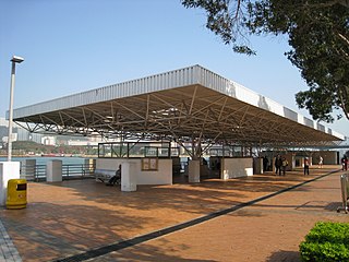
Tsing Yi Pier or Tsing Yi Ferry Terminus (青衣渡輪碼頭) is a ferry pier on Tsing Yi Island, Hong Kong. It replaced Tsing Yi Town old pier that was buried during land reclamation. There were ferries to Tsuen Wan and Central. The service ceased to exist and the pier freed for public use thereafter.
Tsing Yi North Coastal Road, also abbreviated as TYNCR, is a dual carriageway in Tsing Yi, Hong Kong. The road starts at Tsing Tsuen Road, where it travels through the northern part of the island. It ends at Route 3 and Route 8 on the western side of the island at a left-in/left-out interchange, 2.2 kilometres (1.4 mi) from its eastern terminus. The road was first planned in 1998 to relieve traffic coming from Lantau. It was constructed in 1999, and was opened in February 2002.

Tsing Yi Park is a public park on the Tsing Yi Island, Hong Kong with Tsing Yi Estate, Tsing Yi Garden, Broadview Garden and St. Paul's Village in its proximity.It was opened to the public on September 1996, with area of 7.09 hectares, the park was organised by the Leisure and Cultural Service Department, it locates in60 Tsing King Road, Tsing Yi, Kwai Tsing District, New Territories, Hong Kong Special Administrative Region, People's Republic of China. The park features a pond with lots of turles and full of trees and nature.The park was designed to have a pure European style and attract lots of people to go there.
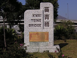
Duplicate Tsing Yi South Bridge or Duplicate Tsing Yi Bridge (青衣複制橋) or Kwai Tsing Bridge (葵青橋) is a 640-metre long bridge connecting Tsing Yi Island and Kwai Chung over the Rambler Channel of Hong Kong in parallel to Tsing Yi Bridge, which deteriorated owing to years of heavy usage. The duplicated bridge was built to relieve the overburdened Tsing Yi Bridge and opened on 26 July 1999 before the commencement of Tsing Yi Bridge renovation. This is the fourth vehicular bridge connecting Kwai Chung and Tsing Yi.

Tsing Yi Sports Ground is a sports ground in Tsing Yi, New Territories, Hong Kong. It is located near the east coast of the island, between Tivoli Garden and Tsing Yi Swimming Pool. It is the home of Hong Kong Premier League club Dreams.
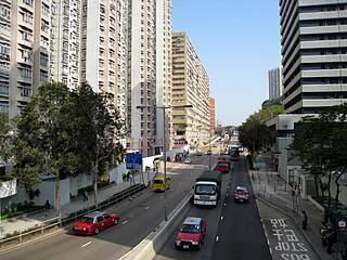
Tsing Yi Heung Sze Wui Road is one of the oldest roads on the Tsing Yi Island, Hong Kong. It was built to connect Tsing Yi Town and Tsing Yi Bridge when the bridge was being built. The name "Tsing Yi Heung Sze Wui" derives from the local Cantonese pronunciation of Tsing Yi Rural Committee. After the reclamation of Tsing Yi Lagoon and Tsing Yi Bay, the road ended at Chun Kwan Temple. The office building of the Tsing Yi Rural Committee is very close to the temple, though it is on Fung Shue Wo Road. Tsing Yi Fire Station and Tsing Yi Police Station are also on the road.
Tsing Yi Fishermen's Children's Primary School was a school for the children of fishermen on Tsing Yi Island in Hong Kong, founded by the Fish Marketing Organisation. Fishermen's Children's Primary Schools marked that fishing once was an important industry in Hong Kong and there was a concern to improve fishermen's literacy. The good harbours besides the Rambler Channel attracted many fishermen and fishing boats such that here was a need to have a school on Tsing Yi Island. The school was finally built on the top of a hill near Moon Tsai Tong. The school survived until the late 1980s when extensive reclamation forced most fishermen to abandon their living on the sea.

Tsing Yi Rural Committee is a rural committee dealing with matters of the village of Tsing Yi Island in Hong Kong.

Tsing Yi Police Station, once also known as Tsing Yi Division Police Station (青衣分區警署) is the only police station on Tsing Yi Island in Hong Kong. The station is located at Tsing Yi Heung Sze Wui Road, between Tsing Yi Police Married Quarters and Tsing Yi Fire Station, below Chung Mei Tsuen of Ha Ko Tan. Its front faces Greenfield Garden, a private housing estate.

The following is an overview of public housing estates on Tsing Yi, including Home Ownership Scheme (HOS), Private Sector Participation Scheme (PSPS), Flat-for-Sale Scheme (FFSS), and Tenant Purchase Scheme (TPS) estates.
Jiulong is the atonal pinyin romanization of various Chinese words and names.
Nanxi or Nan-hsi may refer to:
Tsing Yi Hui was a town on Tsing Yi Island, Hong Kong. Many people at that time referred to the town as Tsing Yi Main Street (青衣大街), namely the main street of the town.
Qingyi River is a major tributary of lower Yangtze River. It is the longest tributary river of lower Yangtze River valley, as well as the longest river originated in Anhui Province. The source of Qingyi River is in Huang Mountains. It has about 30 tributaries, including Hui River, Machuan River, Gufeng River and Yangxi River.
Qingyi River is a major river in western Sichuan. Qingyi means blueish-colored clothes. This name came from the local ancient kingdom Qingyi Qiang Kingdom, in which notable people preferred to wear blue clothes. Qingyi River is the longest tributary of Dadu River, and it is also a major river in upper Yangtze River system. The elevation difference between its source and mouth is more than 5000 meters.

