History
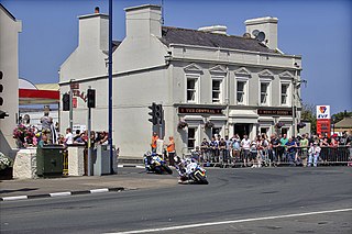
The Quarterbridge spans the River Glass at this point and forms part of the boundary between the parishes of Braddan and Onchan. A bridge at this point was washed away during a storm in 1727 and replaced with a two-arched structure 30 yards downstream. The local mason Charles Scott was contracted in 1809 to build a single-arched span across the River Glass on the present alignment for a price of £280. The bridge was extended upstream in 1862 and there was a further extension downstream in the early 1900s. [3] The public house on the site, The Union Hotel, was damaged by fire in 1830 and replaced by the present Quarterbridge Hotel. A gatehouse and nearby Quarterbridge rail-crossing were built in 1873 for the new Isle of Man Railway's Douglas to Peel line. [4] Road widening on the A1 Peel Road during the winter of 1937 included the demolition of the Brown Bobby public house and road work at the Quarterbridge road junction. In the 1930s a distinctive roadside cafe was built in a modular prefabricated concrete Post-Modernist design on the junction with the A2 Quarterbridge Road. During the winter of 1953/54 road widening to the approach to the Quarterbridge occurred for the 1954 Isle of Man TT Races. [5] In 1963 a roundabout was added to the road junction at the Quarterbridge. [6] In winter 1986/87 there was further reprofiling at the Quarterbridge road junction, with a new road traffic system including two mini-roundabouts, and the removal of a traffic island and cherry trees. In July 2008, the Department of Transport announced a £4 million road safety scheme for the road junction, including the building of a new roundabout and the demolition of the Quarterbridge Hotel. [7] In February/March 2011 the Highways Division of the Department of Infrastructure modified the junction, including major road resurfacing work, improved drainage, elevation changes and repositioning of pedestrian barriers adjacent to the Quarterbridge Hotel. [8]

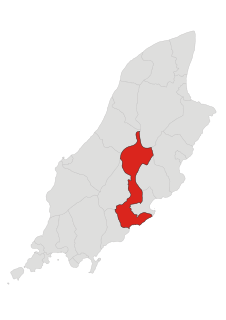
The River Glass is a river on the Isle of Man. The river begins in the area of Injebreck about 10 km north of Douglas, the Island's capital. Flowing down through the West Baldwin Valley, the river joins the River Dhoo to form the River Douglas on the outskirts of Douglas before flowing out to sea. The river has a length of appr. 8.5 km.
Braddan is one of the seventeen parishes of the Isle of Man.

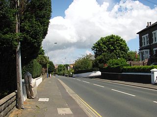
Onchan is a village in the parish of Onchan on the Isle of Man. It is at the north end of Douglas Bay. Although administratively a village, it has the second largest population of settlements on the island, after Douglas, with which it forms a conurbation.
This page is based on this
Wikipedia article Text is available under the
CC BY-SA 4.0 license; additional terms may apply.
Images, videos and audio are available under their respective licenses.

The Isle of Man TT Mountain Course or TT Course is a motor-cycle road- racing circuit located in the Isle of Man. The motor-cycle TT Course is used principally for the Isle of Man TT Races and also the separate event of the Isle of Man Festival of Motorcycling for the Manx Grand Prix and Classic TT Races held in September of each year. The start-line for the Isle of Man TT Mountain Course is located on Glencrutchery Road in the town of Douglas, Isle of Man.

Creg-ny-Baa, Isle of Man [kreg no bæ:]) is a right turn on the Snaefell Mountain Course, the motorcycle racing course used since 1911 for the Isle of Man TT races and from 1923 in the Manx Grand Prix races. It is named after the nearby Keppel Hotel or Creg-ny-Baa public house and restaurant.

Braddan Bridge is a bridge over the river Dhoo on the Douglas to Peel road, from which a halt on the Isle of Man Railway's first line to Peel took its name.
Quarterbridge Crossing was the first major crossing point of the Isle of Man Railway's first line from Douglas to Peel. Opened in 1873, it closed in 1968 with the rest of the line.

St Ninian's Crossroads is situated between the TT Grandstand and the 1st Milestone road-side marker on the Snaefell Mountain Course on the primary A2 Douglas to Ramsey road in the town of Douglas in the Isle of Man.

Bray Hill was formerly a country lane known as the Great Hill during the time of the ownership of the Duke of Atholl, and was previously known as Siberia, originally a triangle-shaped parcel of land in the Murray Estate.

Greeba Castle is situated between the 5th and 6th Milestone road-side markers on the Snaefell Mountain Course used for the Isle of Man TT Races on the junction of the primary A1 Douglas to Peel road in the parish of German in the Isle of Man.

Governor's Bridge is a hairpin bend adjacent to a road junction on the primary A18 Mountain Road in the parish of Onchan in the Isle of Man, with a sudden drop in elevation leading to Governor's Dip, followed by a left-hand bend and finally a right exiting on to the main Glencrutchery Road.

Highroads Course was a road-racing circuit used for the Gordon Bennett British Eliminating Trial held in the Isle of Man for the 1904 and 1905 Tourist Trophy Race involving touring automobiles and cars. The events were held on public roads closed for racing by an Act of Tynwald.
Parliament Square, Ramsey is situated between the 23rd and 24th Milestone road-side markers on the Snaefell Mountain Course used for the Isle of Man TT Races on the junction of the primary A3 Castletown to Ramsey road, the A9 Ramsey to Andreas road and A2 Douglas to Ramsey road situated in the town of Ramsey in the parish of Lezayre in the Isle of Man.

Kate's Cottage is a historic house which is one of Isle of Man's Registered Buildings.
Ballagarraghyn is situated between the 7th and 8th Milestone road-side markers on the Snaefell Mountain Course used for the Isle of Man TT races on the primary A1 Douglas to Peel road in the parish of German in the Isle of Man.

Ballaugh Bridge,, is a hump-backed road bridge over a stream situated between the 17th and 18th Milestone road-side markers on the Snaefell Mountain Course in Ballaugh village, on the primary A3 Castletown-to-Ramsey road and adjacent side junctions with the A10 Ballaugh-to-Ramsey coast road and the tertiary C37 Ballaugh Glen Road in the parish of Ballaugh in the Isle of Man.
The Mountain Mile is a 1.3 mile section of a purpose-built graded road situated between the 27th and 29th Milestone roadside markers on the Snaefell Mountain Course used for the Isle of Man TT and Manx Grand Prix races on the A18 Mountain Road in the parish of Lezayre in the Isle of Man.
Devil's Elbow is a hairpin bend situated on the primary A4 Peel to Kirk Michael coast road in the Isle of Man parish of German.
Quarterbridge Road is situated adjacent to the 1st Milestone road-side marker measured from the startline at TT Grandstand used for the Snaefell Mountain Course on the primary A2 Ramsey to Douglas road in the town of Douglas, Isle of Man.

Douglas Road Corner or Kirk Michael Corner is situated adjacent the 14th Milestone road-side marker on the Snaefell Mountain Course on the primary A3 Castletown to Ramsey Road and the road junction with the A4 Peel to Kirk Michael Coast Road in the parish of Michael in the Isle of Man.


