
Stratford is a town in East London, England, within the London Borough of Newham. Part of the Lower Lea Valley, Stratford is situated 6 miles (9.7 km) east-northeast of Charing Cross, and includes the localities of Maryland and East Village.
West Ham is an area in East London, located 6.1 mi (9.8 km) east of Charing Cross in the west of the modern London Borough of Newham.
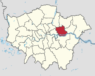
The London Borough of Newham is a London borough created in 1965 by the London Government Act 1963. It covers an area previously administered by the Essex county boroughs of West Ham and East Ham, authorities that were both abolished by the same act. The name Newham reflects its creation and combines the compass points of the old borough names. Situated in the Inner London part of East London, Newham has a population of 387,576, which is the third highest of the London boroughs and also makes it the 16th most populous district in England. The local authority is Newham London Borough Council.
Plaistow is a suburban area of East London, England, within the London Borough of Newham. It adjoins Upton Park to the north, East Ham to the east, Beckton to the south, Canning Town to the south-west and West Ham to the west.

Manor Park is a residential area of the London Borough of Newham in east London, England. The area is bordered by Ilford to the east, Forest Gate to the west, Wanstead to the north, and East Ham to the south.

Canning Town is a district in the London Borough of Newham, East London. The district is located to the north of the Royal Victoria Dock, and has been described as the "Child of the Victoria Docks" as the timing and nature of its urbanisation was largely due to the creation of the dock. The area was part of the ancient parish of West Ham, in the hundred of Becontree, and part of the historic county of Essex. It forms part of the London E16 postcode district.
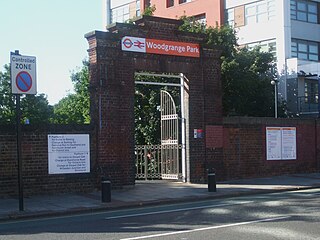
Woodgrange Park railway station is a railway station on Romford Road in Manor Park in the London Borough of Newham, east London. It is served by London Overground, and is on the Gospel Oak to Barking line, 12 miles 1 chain (19.3 km) down the line from Gospel Oak; it lies in Travelcard Zones 3 and 4. It has only limited station buildings and facilities.
Forest Gate is a district in the London Borough of Newham, East London, England. It is located 7 miles (11 km) northeast of Charing Cross.

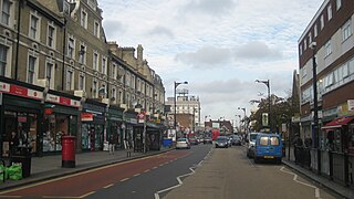
Upton Park is an area of the East London borough of Newham, centred on Green Street which is the boundary between West Ham and East Ham. West Ham United Football Club formerly played at the Boleyn Ground, commonly known as Upton Park.

Essex is a county in the East of England which originated as the ancient Kingdom of Essex and one of the seven kingdoms, or heptarchy, that went on to form the Kingdom of England.

East London is the northeastern part of London, England, east of the ancient City of London and north of the River Thames as it begins to widen. East London developed as London's docklands and the primary industrial centre. The expansion of railways in the 19th century encouraged the eastward expansion of the East End of London and a proliferation of new suburbs. The industrial lands of East London are today an area of regeneration, which are well advanced in places such as Canary Wharf and ongoing elsewhere.

Queen Elizabeth Olympic Park is a sporting complex and public park in Stratford, Hackney Wick, Leyton and Bow, in east London. It was purpose-built for the 2012 Summer Olympics and Paralympics, situated adjacent to the Stratford City development. It contains the Olympic stadium, now known as the London Stadium, and the Olympic swimming pool together with the athletes' Olympic Village and several other Olympic sporting venues and the London Olympics Media Centre. The park is overlooked by the ArcelorMittal Orbit, an observation tower and Britain's largest piece of public art.

Newham University Hospital is an acute general hospital situated in Plaistow in the London Borough of Newham. It is managed by Barts Health NHS Trust.

Green Street is a road in the London Borough of Newham, East London, which forms much of the boundary between East and West Ham.

Stratford Langthorne Abbey, or the Abbey of St Mary's, Stratford Langthorne was a Cistercian monastery founded in 1135 at Stratford Langthorne — then Essex but now Stratford in the London Borough of Newham. The Abbey, also known as West Ham Abbey due to its location in the parish of West Ham, was one of the largest Cistercian abbeys in England, possessing 1,500 acres (6.07 km2) of local land, controlling over 20 manors throughout Essex. The head of the community was known as the Abbot of West Ham.

The University of East London Stratford Campus is based in and around University House, a Grade II* listed building, located in Stratford, London in the London Borough of Newham. The nearest station is Maryland.
The Church of St Edward the Confessor is an anglican church in Romford, in the London Borough of Havering, England. It is part of the Diocese of Chelmsford. The building dates from 1849–50 and replaced an earlier church which was demolished in the mid-19th century. There has been a religious building on the site since the end of the 14th century. The current church was completed to a gothic revival design by the English architect John Johnson. It was designated as a Grade II* listed building by English Heritage in 1952.

The Passmore Edwards Museum was a museum in Stratford, East London. Earlier in its life it was also known as the Essex Local and Educational Museum of Natural History.

Newham Town Hall, formerly East Ham Town Hall, is a municipal building in Barking Road, East Ham, London. The town hall, which is the headquarters of Newham London Borough Council, is a Grade II* listed building.
Stratford Town Hall is a municipal building in Stratford, London. It is a Grade II listed building.

