Savona is a small community located at the west end of Kamloops Lake, where the Thompson River exits it. It is approximately halfway between Kamloops and Cache Creek along the Trans-Canada Highway. The countryside surrounding the community is semi-arid grasslands and hills, which support cattle ranching and agriculture. Savona has about 2000 hours of sunshine and less than 12 inches of precipitation a year. It has a population of approximately 650.

Adams Lake Provincial Park is a provincial park in British Columbia, Canada. It encompasses three distinct parks: Adams Lake Provincial Park, Adams Lake Marine Provincial Park, and Adams Lake Marine Provincial Park.
Bearhole Lake Provincial Park is a provincial park in British Columbia, Canada, located 5 km east of the mining community of Tumbler Ridge, on the Alberta Plateau. Established in January 2001, the park includes 12,705 ha of land in the Boreal White and Black Spruce biogeoclimatic zones within the Kiskatinaw Plateau. It is transition zone with mixed wood forests including spruce, pine, and larch. Bearhole Lake, the headwaters of the Kiskatinaw River provides habitat for trumpeter swans, yellow perch, burbot, rainbow trout, and northern pike.
Bridge Lake Provincial Park is a provincial park in British Columbia, Canada. It is located at the eastern end of the lake of the same name, adjacent to the community of the same name, which is the largest community on the Interlakes Highway. It was established in 1956, and a merge with the nearby Bridge Lake Centennial Park in 2004 and another expansion in 2013 brought the park to its current size.
Bonaparte Provincial Park is an 11,811 hectare provincial park in British Columbia, Canada. It is located within the Bonaparte Plateau.

Birkenhead Lake Provincial Park is a provincial park in British Columbia, Canada, located in the Lillooet Country region to the northeast of Pemberton and immediately northwest of Birkenhead Peak and Gates Lake at the community of Birken.

Canim Beach Provincial Park is a provincial park in British Columbia, Canada, located at the southwest end of Canim Lake in the Interlakes District of the South Cariboo region, adjacent to the Secwepemc Indian reserve community of Canim Lake, British Columbia just northeast of 100 Mile House. The park was established by Order-in-Council in 1956 and expanded by later legislation in 2000 and 2004 to total a current approximate of 8.2 hectares, 3.6 hectares of upland and 4.6 hectares of foreshore.
Charlie Lake Provincial Park is a provincial park in British Columbia, Canada, established on the western shore of Charlie Lake. It is roughly 92 hectares in size.
Edge Hills Provincial Park is a provincial park in British Columbia, Canada, located west of the town of Clinton. The Edge Hills flank the wall of the Fraser Canyon north of Moran Canyon and form a small fore-range between the river and the higher Marble Range just east. Access to the Edge Hills is via the Jesmond Road, which cuts north off the Pavilion Mountain Road at Kelly Lake. A spur road from the Jesmond Road west goes to an overlook atop the Edge Hills, known as Cougar Point.
Lockhart Creek Provincial Park is a provincial park in British Columbia, Canada, located adjacent to Lockhart Beach Provincial Park, 40 km north of Creston, British Columbia on the east shore of Kootenay Lake.
One Island Lake Provincial Park is a provincial park in British Columbia, Canada.
Pennask Lake Provincial Park is a provincial park in British Columbia, Canada, located on the easternmost heights of the Thompson Plateau,50 km (31 mi) to the northwest of the Okanagan town of Peachland.
Porcupine Meadows Provincial Park is a 2,704 hectare provincial park in British Columbia, Canada, located north of Tranquille Lake to the northwest of Kamloops. Its name is a direct translation of the Shuswap word for this area, "pisitsoolsia", named so for the numerous porcupine in the area.
Tsintsunko Lakes Provincial Park is a 333-hectare provincial park in British Columbia, Canada, located south of the Deadman River between Kamloops (SE) and Bonaparte Lake (NW). It is located on the Bonaparte Plateau. It was established April 30, 1996.

The Interlakes, also known as the Interlakes District, is a geographic region of the Interior of British Columbia, Canada, located along and around the Interlakes Highway between 100 Mile House on BC Highway 97 and Little Fort on the North Thompson River. The area is a subregion of the Cariboo and includes the communities of Bridge Lake and Lac des Roches.
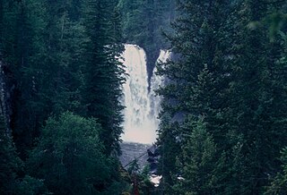
Mahood Falls is a waterfall in Wells Gray Provincial Park located on the Canim River between Canim Lake and Mahood Lake and northeast of 100 Mile House, British Columbia, Canada. The waterfall is 20 m (66 ft) high.
Deka Lake is a freshwater body of water located in the Cariboo region of British Columbia. It is located in the Interlakes area. The lake holds two islands, one of which is privately owned. The name also applies to the surrounding rural community. The name comes from a misspelling of the name Decker, which was the name of a family from the Canim Lake Indian Band.

Sulphurous Lake is a freshwater body in the Cariboo Region of British Columbia, generally considered to be part of the Interlakes area as it is near Deka Lake. The lake has only one boat launch, which is now listed as an official recreation site.
Donnely Lake Provincial Park is a BC Parks and former recreation site located in the Cariboo Regional District of British Columbia. The park was established in 2013. The park entirely surround Donnely Lake, directly north of Deka Lake. A single trail from the former recreation site of the same name leads between Bowers Lake Forest Service Road and the lake, providing access for camping and fishing.
