Franklin Township is a township in Somerset County, New Jersey, United States. As of the 2010 United States Census, the township's population was 62,300, reflecting an increase of 11,397 (+22.4%) from the 50,903 counted in the 2000 Census, which had in turn increased by 8,123 (+19.0%) from the 42,780 counted in the 1990 Census.

The Delaware and Raritan Canal is a canal in central New Jersey, United States, built in the 1830s, that served to connect the Delaware River to the Raritan River. It was an efficient and reliable means of transportation of freight between Philadelphia and New York City, especially coal from the anthracite fields in eastern Pennsylvania. The canal allowed shippers to cut many miles off the existing route from the Pennsylvania coal fields, down the Delaware, around Cape May, and up along the Atlantic Ocean coast to New York City.

Blackwells Mills is an unincorporated community and census-designated place (CDP) located in Franklin Township, in Somerset County, New Jersey, United States. As of the 2010 United States Census, the CDP's population was 803.

Titusville is an unincorporated community located within Hopewell Township in Mercer County, New Jersey, United States. The area includes a post office with its own ZIP code (08560), a small village of homes, and a large park dedicated to George Washington's crossing of the Delaware River in 1776. Titusville was added to the National Register of Historic Places in 1983.

Raritan Valley Community College (RVCC) is an accredited, coeducational, two-year, public, community college located in North Branch, New Jersey. RVCC offers Associate's degree programs leading to an Associate of Arts (A.A.), Associate of Science (A.S.), Associate of Fine Art (A.F.A) or an Associate of Applied Science (A.A.S.), as well as certificate programs and continuing education courses.

The Millstone River is a 38.6-mile-long (62.1 km) tributary of the Raritan River in central New Jersey in the United States.

This is a list of properties and districts listed on the National Register of Historic Places in New Jersey. There are more than 1,700 listed sites in New Jersey. All 21 counties in New Jersey have listings on the National Register.
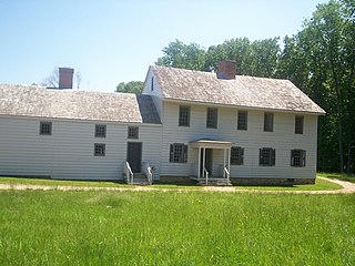
Rockingham is a historic house that was the home of John Berrien (1711–1772) and George Washington's final headquarters of the Revolutionary War. It is located at 84 Laurel Avenue, Franklin Township in Somerset County, New Jersey. The house was originally located on the hillside east of the Millstone River at Rocky Hill. It has been moved within southern Franklin Township several times, and is now closer to Kingston than to Rocky Hill. The residence is a featured part of the Millstone River Valley Scenic Byway. The oldest portion of the house was built as a two-room, two-story saltbox style house c. 1710; a kitchen and additional rooms were added on in the early 1760s, expanding with the Berrien family. The first reference to the house as "Rockingham" does not appear until a 1783 newspaper advertisement to sell the house, a name given most likely in honor of the Marquess of Rockingham.
The Meadows Foundation of Somerset County, New Jersey is a nonprofit corporation founded in 1978. It oversaw the restoration of seven historic houses in Somerset.

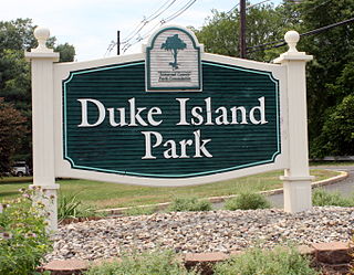
The Six Mile Run Reservoir Site, part of the Delaware and Raritan Canal State Park, is located in Franklin Township, Somerset County, New Jersey, United States. It is adjacent to the Delaware and Raritan Canal. It covers 3,037 acres (12.29 km2). The reservoir plan was to flood the Six Mile Run watershed. The Six Mile Run is a tributary of the Millstone River that, with its tributaries, drains a large area in central Franklin Township, Somerset County, New Jersey and western portions of North Brunswick and South Brunswick Townships in Middlesex County, New Jersey. It derives its name, along with other streams, from the distance early surveyors estimated it was from the point where the historic King's Highway left the Raritan River at New Brunswick to the point the roadway crossed the stream. The estimates were not very accurate but the stream names have remained in use ever since.
Six Mile Run is an unincorporated community and census-designated place (CDP) located in Franklin Township, in Somerset County, New Jersey, United States. As of the 2010 United States Census, the CDP's population was 3,184.

The Blackwells Mills Canal House is located at Blackwells Mills Road and Canal Road in Franklin Township, Somerset County, New Jersey, United States, on the Delaware and Raritan Canal. Across the canal is Blackwells Mills, New Jersey.

The Port Mercer Canal House is a historic house along the Delaware and Raritan Canal. It is located at 4278 Quakerbridge Road in the Port Mercer section of Lawrence Township, Mercer County, New Jersey, United States, near the border of West Windsor Township and Princeton, New Jersey. The house was built in the 1830s as housing for bridgetender and his family. The bridgetender was needed to open the swing bridge when canal boats came through, then close it to allow traffic to cross over the canal. From approximately 1900 to 1934, the bridgetender was John Arrowsmith. He and his wife lived in the three bedroom house with their eight children. The Arrowsmiths loved living at the house and their children enjoyed sleeping outside by the canal in the summer and skating on the frozen canal to Trenton in the winter.
The Raritan River Greenway is a proposed path in Somerset County, New Jersey that would link Branchburg Township to the East Coast Greenway with the Delaware and Raritan Canal trail in South Bound Brook. Raritan River Greenway is a priority park for Somerset County.

Neshanic Station is an unincorporated community located within Branchburg Township, in Somerset County, New Jersey, United States. In 2016 most of the village was listed on the National Register of Historic Places as the Neshanic Station Historic District.
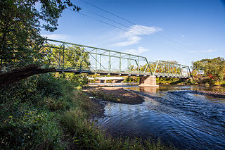
The Nevius Street Bridge once carried car traffic across the Raritan River between Hillsborough Township and Raritan Borough in Somerset County, New Jersey, United States. In the 1840s a wooden bridge crossed at this location. The current 150-foot-long (46 m) bridge was built in 1886 by the Wrought Iron Bridge Company of Canton, Ohio. It is a double intersection Pratt truss bridge. The construction of the nearby John Basilone Veterans Memorial Bridge replaced the Nevius Street Bridge in 2005; the bridge now serves as a pedestrian bridge, connecting River Road in Hillsborough with the Raritan River Greenway. The bridge, described using its historic name, Raritan Bridge, was added to the National Register of Historic Places on November 12, 1992 for its engineering and method of construction.

Mile Run is a tributary of the Raritan River in New Brunswick, New Jersey, in the United States.

The Rocky Hill Historic District encompasses the historic core of Rocky Hill, New Jersey along Washington Street and Montgomery, Princeton, and Crescent Avenues. The village is approximately one square mile and traces its beginnings to the 18th century, when George Washington stayed at Rockingham, and its major growth period to the second quarter of the 19th century. The district encompasses 145 buildings, only 12 of which are non-contributing, and has sustained its historic character without the intrusion of modern structures or parking lots. The most notable landmark in the village is Dutch Reformed Church, built in 1856 in the Carpenter Gothic style. The district was added to the National Register of Historic Places on July 8, 1982 for its significance in archeology, architecture and commerce.

The Somerset Roller Mills, also known as the Jacobs Creek Grist Mill, are a small former gristmill complex, originally built in the early 18th century, in Titusville, New Jersey.