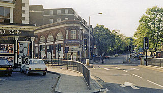
Chalk Farm is a small urban district of north west London, lying immediately north of Camden Town, in the London Borough of Camden.
St Pancras is a district in central London. It was originally a medieval ancient parish and subsequently became a metropolitan borough. The metropolitan borough then merged with neighbouring boroughs and the area it covered now forms around half of the modern London Borough of Camden. The area of the parish and borough includes the sub-districts of Camden Town, Kentish Town, Gospel Oak, Somers Town, King's Cross, Chalk Farm, Dartmouth Park, the core area of Fitzrovia and a part of Highgate.

Regent's Park is one of the Royal Parks of London. It occupies 410 acres (170 ha) of high ground in north-west Inner London, administratively split between the City of Westminster and the Borough of Camden. In addition to its large central parkland and ornamental lake, it contains various structures and organizations both public and private, generally on its periphery, including Regent's University and London Zoo.

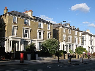
Primrose Hill is a Grade II listed public park located north of Regent's Park in London, England, first opened to the public in 1842. It was named after the 64 metres (210 ft) natural hill in the centre of the park, the second highest natural point in the London Borough of Camden. The hill summit has a clear view of central London, as well as Hampstead and Belsize Park to the north and is adorned by an engraved quotation from William Blake. Based on the popularity of the park, the surrounding district and electoral ward were named Primrose Hill. The Primrose Hill district is in the London Borough of Camden, England.

Baker Street is a street in the Marylebone district of the City of Westminster in London. It is named after builder William Baker, who laid out the street in the 18th century. The street is most famous for its connection to the fictional detective Sherlock Holmes, who lived at a fictional 221B Baker Street address on the north of the street. The area was originally high class residential, but now is mainly occupied by commercial premises.

Swiss Cottage is an area of Hampstead in the London Borough of Camden, England. It is centred on the junction of Avenue Road and Finchley Road and includes Swiss Cottage tube station. Swiss Cottage lies 3.25 miles (5.23 km) north-northwest of Charing Cross. The area was named after a public house in the centre of it, known as "Ye Olde Swiss Cottage".

The River Medlock is a river in Greater Manchester, England, which rises near Oldham and flows south and west for 10 miles to join the River Irwell in Manchester city centre.
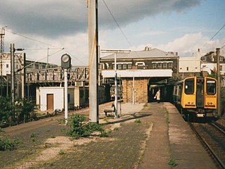
Primrose Hill was a railway station in Chalk Farm, in the London Borough of Camden, opened by the North London Railway as Hampstead Road in 1855. It was named Chalk Farm from 1862 until 1950, when it was given its final name. From the 1860s to 1915, it was linked with a formerly separate station opened by the London and North Western Railway in 1852. The station closed in 1992, and the platform buildings and canopies were removed in 2008.

Belsize Park is an affluent residential area of Hampstead in the London Borough of Camden, England.

Church End is a locality within Finchley in the London Borough of Barnet in London, England. Aside from its church it centres on Finchley Central Underground station. Church End is an old village, now a suburban development, centred 7 miles (11 km) north-northwest of Charing Cross.

Albany Street is a road in London running from Marylebone Road to Gloucester Gate following the east side of Regent's Park. It is about three-quarters of a mile in length.
Haverstock is an area of the London Borough of Camden: specifically the east of Belsize Park, north of Chalk Farm and west of Kentish Town. It is centred on Queens Crescent and Malden Road. Gospel Oak is to the north, Camden Town to the south.
The London Borough of Camden was created in 1965 from the former area of the metropolitan boroughs of Hampstead, Holborn, and St Pancras, which had formed part of the County of London. The borough was named after Camden Town, which had gained its name from Charles Pratt, 1st Earl Camden in 1795. Since the 17th century, many famous people have lived in its various districts and neighbourhoods.

The London Borough of Camden is a London borough in Inner London, England. Camden Town Hall, on Euston Road, lies 1.4 mi (2.3 km) north of Charing Cross. The borough was established on 1 April 1965 and includes the former Central London borough of Holborn, and St Pancras and Hampstead.

The Queen's is a pub and former hotel in Regent's Park Road, Primrose Hill, London.
This is a list of the etymology of street names in the area of Regent's Park in London ; the area has no formal boundaries, though it generally thought to be delimited by Prince Albert Road to the north, Park Village East and Hampstead Road/the Euston railway line/Eversholt Street to the east, Euston Road and Marylebone Road to the south and Park Road and Baker Street to the west.

Primrose Hill is a district in the London Borough of Camden, England.

Carlton Vale is a street that runs through Kilburn and Maida Vale in London. Some of its route forms the boundary between the City of Westminster to the south and the London Borough of Brent to the north. To the west the street continues as Kilburn Lane through Queen's Park, while to the east it becomes Carlton Hill running into St. John's Wood. Carlton Vale crosses or meets several roads including Kilburn Park Road, Cambridge Road and Randolph Avenue.

Gloucester Avenue is a street in the Primrose Hill area of London, England. Located in the London Borough of Camden, it is a residential road featuring many nineteenth century properties including several pubs as well as the neo-Georgian Cecil Sharp House. For much of its route it runs adjacent to the West Coast Main Line out of Euston Station.

The Chalk Farm Tavern was a public house located in what is today Regent's Park Road in Primrose Hill, London.


