Robert Fulton was an American engineer and inventor who is widely credited with developing a commercially successful steamboat; the first was called The North River Steamboat. In 1807 that steamboat traveled on the Hudson River with passengers, from New York City to Albany and back again, a round trip of 300 miles, in 62 hours. The success of his steamboat changed river traffic and trade on major American rivers.

Fulton is a home rule-class city in Fulton County, Kentucky, United States. The population was 2,445 at the 2010 census, down from 2,775 at the 2000 census. It was once known as the "Banana Capital of the World", because 70% of imported bananas to the U.S. used to be shipped through the city. U.S. Route 51 runs through the center of downtown. Fulton is part of the Union City-Hickman, TN–KY Micropolitan Statistical Area.

Mayfield is a town in Fulton County, New York, United States. The population of the town was 6,495 at the 2010 census.

New York State Route 30A (NY 30A) is a state highway in the Capital District of New York in the United States. It serves as a westerly alternate route of NY 30 from near the Schoharie County village of Schoharie to the Fulton County hamlet of Riceville, 1 mile (1.6 km) south of the village of Mayfield. While NY 30 heads generally north–south between the two locations and passes through Amsterdam, NY 30A veers west to serve the villages of Fonda and Fultonville and the cities of Johnstown and Gloversville. Along the way, it connects to several major east–west highways, including U.S. Route 20 (US 20) in Esperance and the New York State Thruway in Fultonville.
The Union City Micropolitan Statistical Area, as defined by the United States Census Bureau, is an area consisting of two counties – one in northwest Tennessee and one in southwest Kentucky – anchored by the city of Union City, Tennessee. As of the 2000 census, the μSA had a population of 40,202.

The Confederate Memorial includes a 6-foot-tall (1.8 m) Confederate soldier statue atop an arch anchored in the Fulton, Kentucky Fairview Cemetery. Funded in 1902 by the Colonel Ed Crossland Chapter No. 347 of the United Daughters of the Confederacy, the historic monument is the only such monument in Kentucky to feature an arched base, made of rough-hewn limestone.

The Confederate Memorial Gateway in Hickman, Kentucky is a historic cemetery gateway in Fulton County, Kentucky. It was funded in 1913 by the Private Robert Tyler Chapter of the United Daughters of the Confederacy. It was placed on the National Register of Historic Places in 1997.

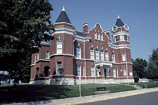
This is a list of the National Register of Historic Places listings in Fulton County, Kentucky.
U.S. Route 45 enters Kentucky at Fulton in Fulton County and travels northeast through Hickman County, Graves County, and McCracken County. After passing through Mayfield in Graves County it heads directly north into Paducah as a four-lane highway. In Paducah, US 45 serves as a major artery, intersecting with Interstate 24 at Exit 7, and intersecting US 60 and 62. U.S. 45 leaves Kentucky from Paducah's northern border across the two-lane, metal-grate Brookport Bridge to Brookport, Illinois across the Ohio River.
U.S. Route 51 in Kentucky runs 42 miles (68 km) through the western portion of the state from the Tennessee state line at Fulton to the Illinois state line at Cairo, Illinois. It is a mostly rural route, also serving the towns of Clinton, Arlington, Bardwell and Wickliffe. It also carries part of the Great River Road near the northern end of its route in Kentucky.

Riceville is an unincorporated community in Johnson County, Kentucky, United States. The community's first post office was established on October 17, 1891 and may have been named after local resident, Sherman Rice. A few years later, the community began to flourished after the Big Sandy & Kentucky River Railroad was extended into the community and a lumber mill was established. Riceville's ZIP code is 41252.
Riceville is an unincorporated community in Pittsylvania County, in the U.S. state of Virginia.
Ebenezer was an unincorporated community in Fulton County, Kentucky, United States.
Beech Grove was an unincorporated community in Fulton County, Kentucky, United States. It was also known as Watson.
Miller is an unincorporated community in Fulton County, Kentucky, United States.
Kentucky Route 94 is a 79.816-mile (km) state highway in Kentucky that runs from Tennessee State Route 78 at the Tennessee state line to Kentucky Route 80 southwest of the unincorporated community of Aurora via Hickman, Water Valley, and Murray.
Riceville is an unincorporated community in Crawford County, Indiana, in the United States.
Kentucky Route 166 is a 13.279-mile (21.370 km) state highway in Fulton County, Kentucky. It runs from Kentucky Route 125 southeast of Hickman to U.S. Route 45 and Kentucky Route 1648 in northwestern Fulton.