
Latimer County is a county located in the southeastern part of the U.S. state of Oklahoma. Its county seat is Wilburton. As of the 2010 census, the population was 11,154. The county was created at statehood in 1907 and named for James L. Latimer, a delegate from Wilburton to the 1906 state Constitutional Convention. Prior to statehood, it had been for several decades part of Gaines County, Sugar Loaf County, and Wade County in the Choctaw Nation.

Red Oak is a town in Latimer County, Oklahoma, United States. The population was 549 at the 2010 census.

Butterfield Overland Mail was a stagecoach service in the United States operating from 1858 to 1861. It carried passengers and U.S. Mail from two eastern termini, Memphis, Tennessee, and St. Louis, Missouri, to San Francisco, California. The routes from each eastern terminus met at Fort Smith, Arkansas, and then continued through Indian Territory (Oklahoma), Texas, New Mexico, Arizona, Mexico, and California ending in San Francisco. On March 3, 1857, Congress authorized the U.S. postmaster general, at that time Aaron V. Brown, to contract for delivery of the U.S. mail from St. Louis to San Francisco. Prior to this, U.S. Mail bound for the Far West had been delivered by the San Antonio and San Diego Mail Line since June 1857.

Skullyville is an unincorporated rural community in Le Flore County, Oklahoma, United States. It is approximately one mile east of Spiro and 15 miles (24 km) southwest of Fort Smith, Arkansas. It was capital of the Choctaw Nation, capital of the Moshulatubbee District of the Choctaw Nation, and in the late 1850s a stop for the Butterfield Stage. It developed as a political and business center of the nation before the Civil War. Skullyville was the site of the Choctaw Agency from 1832 until 1839.
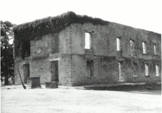
Boggy Depot is a ghost town and Oklahoma State Park that was formerly a significant city in the Indian Territory. It grew as a vibrant and thriving town in present-day Atoka County, Oklahoma, United States, and became a major trading center on the Texas Road and the Butterfield Overland Mail route between Missouri and San Francisco. After the Civil War, when the MKT Railroad came through the area, it bypassed Boggy Depot and the town began a steady decline. It was soon replaced by Atoka as the chief city in the area. By the early 20th century, all that remained of the community was a sort of ghost town.
The Butterfield Overland Mail in Indian Territory was part of the overall Butterfield Overland Mail service (1857–1861) created by Congress March 3, 1857. The route crossed Indian Territory from Colbert's Ferry to Fort Smith, Arkansas which was the Center for the Overland Mail's' 7th Division. Fort Smith was also the junction point of the south bound coaches with the Memphis mail and its passengers. From Fort Smith the 7th Division route crossed the Poteau River into Indian Territory into the Choctaw Nation at Skullyville and left the Chickasaw Nation at Colbert's Ferry into Texas. There were 12 stage stations in Indian Territory, located from 13 to 19 miles (31 km) apart. The total length of the route across the territory was approximately 197 miles (317 km). The Butterfield route met with the Texas Road near Geary's Station and followed it southward to the Red River.
Colbert's Ferry was an important Red River crossing between Texas and Indian Territory from about 1853 to 1899. Both the Texas Road and the Butterfield Overland Mail route crossed here. It was located on the Texas Road about 3 miles (4.8 km) southeast of present–day Colbert, Bryan County, Oklahoma. The nearest town on the Texas side of the river is Denison.
Nail's Station was a stage stand on the old Butterfield Overland Mail route and the Texas Road in Indian Territory. Sometimes called Blue River Station or Nail's Crossing, it was located on the east side of Blue River in what is now Bryan County, Oklahoma. It was operated by Joel H. Nail, a member of a prominent Choctaw family.
Fisher's Station, also known as Carriage Point, was a stage stand on the old Butterfield Overland Mail route and the Texas Road in Indian Territory. It was located at the head of Island Bayou in what is now Bryan County, Oklahoma. Island Bayou was then the dividing line between the Chickasaw and Choctaw Nations. From March 23, 1869, to February 6, 1871, the Carriage Point post office existed at the site and it is generally referred to by that name in the area. The Fishers were a well known Choctaw family.
Geary's Station was a stage stand on the old Butterfield Overland Mail route in Indian Territory. Sometimes called Geary's Crossing, it was located on the east side of LIttle Boggy Creek in what is now Atoka County, Oklahoma. It was operated by A.W. Geary, an inter-married Choctaw. His wife Lucy was the sister of a Choctaw chief. The Choctaw Nation had awarded Geary the privilege of building a bridge and tollgate at the Little Boggy crossing on the Fort Smith-Boggy Depot Road in 1858, which later became the route of the Butterfield Overland Mail stage.
Waddell's Station was a stage stand on the old Butterfield Overland Mail route in Indian Territory. It was located in what is now Atoka County, Oklahoma. It is sometimes confused with Roger's Station, a post-Civil War stage stand and post office, which was three miles (5 km) in an easterly direction from Waddell's.
Blackburn's Station was a stage stand on the old Butterfield Overland Mail route in Indian Territory. It was located in what is now Pittsburg County, Oklahoma. The station was named for Casper B. Blackburn, an inter-married Choctaw and trader.
Pusley's Station was a stage stand on the old Butterfield Overland Mail route in Indian Territory. It was located in what is now Latimer County, Oklahoma, on the south side of Gains Creek. The station was named for Silas Pusley, a trader and member of a prominent Choctaw family. In 1859, the Choctaw Council granted Pusley the right to build a bridge and tollbooth across Gains Creek near his station.

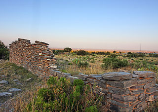
Holloway's Station, or The Narrows, was a stage stand on the old Butterfield Overland Mail route in Indian Territory. It was located near "The Narrows" at upper Brazil Creek in what is now Latimer County, Oklahoma. The station was named for William Holloway, the stage agent. In 1858, the Choctaw Council granted Holloway the right to construct a turnpike and tollbooth at "The Narrows". Holloway left after Butterfield discontinued service in 1861.
Trahern's Station was a stage stand on the old Butterfield Overland Mail route in Indian Territory. It was located in what is now Le Flore County, Oklahoma. The station was named for Judge James N. Trahern, the stage agent. Trahern was a Choctaw Indian and a long-time county judge for Skullyville County, Choctaw Nation.
Walker's Station was a stage stand on the old Butterfield Overland Mail route in Indian Territory. It was located at the old Choctaw Agency in Skullyville, in what is now Le Flore County, Oklahoma. The station was named for Tandy Walker, Choctaw chief, and later, Governor of the Choctaw Nation. The old Choctaw Agency building was his residence.
Island Bayou is a 46.0-mile-long (74.0 km) tributary of the Red River in Oklahoma.

Oak Grove Butterfield Stage Station is located in the western foothills of the Laguna Mountains, in northern San Diego County, California. It is located on State Route 79, 13 miles (21 km) northwest of Warner Springs and Warner's Ranch. The station was built on the site of Camp Wright, an 1860s Civil War outpost.
Fort Washita is the former United States military post and National Historic Landmark located in Durant, Oklahoma on SH 199. Established in 1842 by General Zachary Taylor to protect citizens of the Choctaw and Chickasaw Nations from the Plains Indians it was later abandoned by Federal forces at the beginning of the American Civil War. Confederate troops held the post until the end of the war when they burned the remaining structures. It was never reoccupied by the United States military. After years in private hands the Oklahoma Historical Society bought the fort grounds in 1962 and restored the site. Today, the Fort Washita Historic Site and Museum is a tourist attraction and hosts several events throughout the year, and it is jointly managed by the Chickasaw Nation and the Oklahoma Historical Society.
In Texas, the Butterfield Overland Mail service created by Congress on March 3, 1857, operated until March 30, 1861. The route that was operated extended from San Francisco, California to Los Angeles, then across the Colorado Desert to Fort Yuma, then across New Mexico Territory via, Tucson and Mesilla, New Mexico to Franklin, Texas, midpoint on the route. The route through Texas followed first the northern route to the Pecos River and downstream to Horse Head Crossing. The route in West Texas was changed in 1859, in order to secure a better water supply on the route and to provide mail service to a more settled area, the stages between Franklin and the Pecos River followed the San Antonio-El Paso Road to Camp Stockton and then turned east to Horsehead Crossing. From Horsehead Crossing the route crossed Texas to the Red River and into Indian Territory. In 1860 the route was changed to another route from Jacksboro to Sherman via Decatur due to the building of a new toll bridge at Bridgeport, that avoided delays crossing the West Fork of the Trinity River when it was flooded. From Colberts Ferry the route went on to Fort Smith, then up across Arkansas and southwest Missouri to Tipton with the final leg by train to St. Louis. The Texas mail route was so long that the route there, like that in California, was divided into two divisions each under a superintendent.

