Ritner Creek

Last updated
Ritner Creek
Interior of Ritner Creek Bridge.jpg
Ritner Creek Bridge interior in 2011
Name origin:For Sebastian Ritner, a settler whose donation land claim was along the creek [1]
Country United States
State Oregon
County Polk
Source Central Oregon Coast Range
 - locationnear Bald Mountain
 - elevation1,292 ft (394 m) [2]
 - coordinates 44°46′27″N123°32′29″W / 44.77417°N 123.54139°W / 44.77417; -123.54139
Mouth Luckiamute River
 - locationsouth of Pedee
 - elevation279 ft (85 m) [3]
 - coordinates 44°43′43″N123°26′36″W / 44.72861°N 123.44333°W / 44.72861; -123.44333 Coordinates: 44°43′43″N123°26′36″W / 44.72861°N 123.44333°W / 44.72861; -123.44333   [3]
USA Oregon location map.svg
Red pog.svg
Location of the mouth of Ritner Creek in Oregon

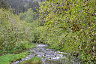
Ritner Creek is a tributary of the Luckiamute River in Polk County in the U.S. state of Oregon. [4] The creek begins near Bald Mountain in the Central Oregon Coast Range and flows generally southeast to meet the Luckiamute southwest of Pedee and north of Kings Valley. The confluence is 31 miles (50 km) upstream of the Luckiamute's mouth on the Willamette River. [4] Named tributaries of Ritner Creek from source to mouth are Sheythe, Love, Clayton, and Kinsey creeks. [4]

Luckiamute River watercourse in the United States of America

The Luckiamute River is a tributary of the Willamette River, about 61 miles (98 km) long, in western Oregon in the United States. It drains an area of Central Oregon Coast Range and the western Willamette Valley northwest of Corvallis.

Polk County, Oregon county in Oregon, USA

Polk County is a county located in the U.S. state of Oregon. As of the 2010 census, the population was 75,403, making it the least populous county in the Willamette Valley. The county seat is Dallas. The county is named for James Knox Polk, the 11th president of the United States.

U.S. state constituent political entity sharing sovereignty as the United States of America

In the United States, a state is a constituent political entity, of which there are currently 50. Bound together in a political union, each state holds governmental jurisdiction over a separate and defined geographic territory and shares its sovereignty with the federal government. Due to this shared sovereignty, Americans are citizens both of the federal republic and of the state in which they reside. State citizenship and residency are flexible, and no government approval is required to move between states, except for persons restricted by certain types of court orders. Four states use the term commonwealth rather than state in their full official names.

Contents

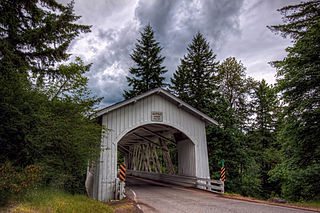
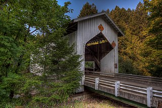
Ritner Creek passes under Oregon Route 223 just before entering the river. The Ritner Creek Bridge, a 75-foot (23 m) covered bridge, carried the highway over the creek until 1976. Replaced by a concrete span, it was the last covered bridge on an Oregon state highway. [5]

Oregon Route 223 highway in Oregon

Oregon Route 223 is a state highway in the U.S. State of Oregon, which runs between the town of Wren, Oregon and the city of Dallas, Oregon. It is known as the Kings Valley Highway No. 191 and is 31 miles (50 km) long. It lies in Benton and Polk counties.

Ritner Creek Bridge

The Ritner Creek Bridge was the last covered bridge on a state highway in Oregon. It carried Oregon Route 223 (OR 223) over Ritner Creek between Pedee and Kings Valley, about 15 miles (24 km) south of Dallas, or 10 miles (16 km) north of the junction with U.S. Route 20 (US 20) in Wren. Built in 1927, in 1976 the bridge was lifted from its foundation and relocated just downstream of its original site and replaced by a concrete bridge. The bridge was constructed in 1927 by Hamer and Curry Contractors to Oregon State Highway Commission plans. The initial construction cost was $6,964. The original portal design was rounded at the edges but was changed to a square design in the early 1960s to accommodate larger loads to pass.

Covered bridge wooden bridge with protective cover

A covered bridge is a timber-truss bridge with a roof, decking, and siding which, in most covered bridges, create an almost complete enclosure. The purpose of the covering is to protect the wooden structural members from the weather. Uncovered wooden bridges typically have a lifespan of only 20 years because of the effects of rain and sun, but a covered bridge could last 100 years.

Name

The creek was named for Sebastian Ritner, who emigrated to Oregon in 1845. His donation land claim included part of the creek. A railroad station named Ritner was part of the Valley and Siletz Railroad. It was along the line about 2 miles (3 km) north of Kings Valley. [1]

Donation Land Claim Act

The Donation Land Claim Act of 1850, sometimes known as the Donation Land Act, was a statute enacted in late 1850 by the United States Congress. It was intended to promote homestead settlements in the Oregon Territory. The law, a forerunner of the later Homestead Act, brought thousands of white settlers into the new territory, swelling the ranks of settlers traveling along the Oregon Trail. 7,437 land patents were issued under the law, which expired in late 1855.

Valley and Siletz Railroad

The Valley and Siletz Railroad (VS) is a 40.6-mile (65.3 km) defunct railroad located in Polk and Benton counties in the U.S. state of Oregon.

Parks

The covered bridge was saved and moved to an adjacent site that doubles as a small county park, the Minnie Ritner Ruiter Wayside. The park, open all year during daylight hours, has picnic tables and a portable restroom. [6]

Further upstream along Gage Road and Ritner Creek is Ritner Creek Park, another county recreation site. Amenities include fire pits, picnic tables, walking trails, and a restroom. This park is also open all year between sunrise and a half-hour after sunset. [7]

See also

Related Research Articles

Molalla River river in the United States of America

The Molalla River is a 51-mile (82 km) tributary of the Willamette River in the northwestern part of Oregon in the United States. Flowing northwest from the Cascade Range through Table Rock Wilderness, it passes the city of Molalla before entering the larger river near Canby. The Molalla is the largest Willamette tributary unblocked by a dam.

Grave Creek (Oregon) river in the United States of America

Grave Creek is a tributary, about 40 miles (64 km) long, of the Rogue River in southwestern Oregon in the United States.

Course of the Willamette River

The Willamette River is a 187-mile (301 km) tributary of the Columbia River in the U.S. state of Oregon. The upper tributaries of the Willamette originate in mountains south and southeast of Eugene and Springfield. Formed by the confluence of the Middle Fork Willamette River and Coast Fork Willamette River near Springfield, the main stem meanders generally north from source to mouth. The river's two most significant course deviations occur at Newberg, where the stream turns sharply east, and about 18 miles (29 km) downriver from Newberg, where it turns north again. Near its mouth, the river splits into two channels that flow around Sauvie Island. The main channel enters the Columbia about 101 miles (163 km) from the larger stream's mouth on the Pacific Ocean, and the smaller Multnomah Channel enters the Columbia about 14.5 miles (23.3 km) further downstream near St. Helens in Columbia County.

Little North Santiam River river in the United States of America

The Little North Santiam River is a 27-mile (43 km) tributary of the North Santiam River in western Oregon in the United States. It drains 113 square miles (290 km2) of the Cascade Range on the eastern side of the Willamette Valley east of Salem.

Little Luckiamute River river in the United States of America

The Little Luckiamute River is a stream in Polk County in the U.S. state of Oregon. It rises in the Central Oregon Coast Range near Fanno Peak and joins the Luckiamute River about 4 miles (6 km) upstream of the Sarah Helmick State Recreation Site southwest of Monmouth.

Thomas Creek (Linn County, Oregon) stream in Linn County in the U.S. state of Oregon

Thomas Creek is a stream, about 35 miles (56 km) long, in Linn County in the U.S. state of Oregon. Beginning in Willamette National Forest on the western slopes of the Cascade Range, the creek flows generally west through Santiam State Forest and farmland to meet the South Santiam River west of Scio.

Willamina Creek river in the United States of America

Willamina Creek is a tributary, about 20 miles (32 km) long, of the South Yamhill River in the U.S. state of Oregon. Beginning in the Northern Oregon Coast Range in Yamhill County, it briefly enters and exits a small part of eastern Tillamook County, then flows generally south to meet the larger stream at Willamina, near the border with Polk County.

Mosby Creek (Oregon) river in the United States of America

Mosby Creek is a 21-mile (34 km) tributary of the Row River in Lane County, in the U.S. state of Oregon. It begins at the confluence of the east and west forks of the creek near the Calapooia Divide and the border with Douglas County. From its source it flows generally north-northwest to meet the river slightly east of Cottage Grove and about 4 miles (6 km) from the larger stream's confluence with the Coast Fork Willamette River.

Crabtree Creek (South Santiam River tributary)

Crabtree Creek is a tributary of the South Santiam River in Linn County in the U.S. state of Oregon. It begins in the western foothills of the Cascade Range at Crabtree Mountain near Crabtree Lake. From there it flows generally west to meet the larger stream about 3 miles (5 km) upstream of where the South Santiam merges with the North Santiam River to form the Santiam River.

Deadwood Creek (Oregon) river in the United States of America

Deadwood Creek is a tributary of Lake Creek in the Siuslaw River basin in Lane County in the U.S. state of Oregon. Beginning near Taylor Butte in the Central Oregon Coast Range, it meanders generally southwest through the Siuslaw National Forest to meet the larger creek at the rural community of Deadwood. This is 5 miles (8 km) from Lake Creek's confluence with the river near Swisshome and 34 miles (55 km) by water from the Siuslaw River's mouth on the Pacific Ocean at Florence.

Fall Creek (Middle Fork Willamette River)

Fall Creek is a 34-mile (55 km) tributary of the Middle Fork Willamette River in Lane County in the U.S. state of Oregon. Beginning in the Cascade Range, the creek flows generally west through the Willamette National Forest to enter the Middle Fork upstream of Jasper, southeast of Springfield and Eugene.

Sandy Creek (Middle Fork Coquille River)

Sandy Creek is a tributary of the Middle Fork Coquille River in the U.S. state of Oregon. It begins near Scott Mountain in the Southern Oregon Coast Range and flows southwest to meet the river near the rural community of Remote. The creek passes under Oregon Route 42 and enters the river about 16 miles (26 km) from its mouth on the South Fork Coquille River near Myrtle Point. The creek's only named tributary is Fetter Creek, which enters from the right slightly upstream of Remote.

Rocky Creek (Oregon) short coastal stream in Lincoln County in the U.S. state of Oregon

Rocky Creek is a short coastal stream in Lincoln County in the U.S. state of Oregon. It begins near the western extremities of the Central Oregon Coast Range and flows generally west to the ocean south of Depot Bay and north of Otter Rock. It has no named tributaries.

Cavitt Creek Bridge

Cavitt Creek Bridge is a covered bridge in Douglas County in the U.S. state of Oregon. Built by Floyd C. Frear in 1943, it carries Cavitt Creek Road over the Little River about 20 miles (32 km) east of Roseburg. Cavitt Creek and the road and bridge were named for Robert L. Cavitt, who settled along the creek in the mid-19th century.

Cavitt Creek river in the United States of America

Cavitt Creek is a tributary of the Little River in Douglas County in the U.S. state of Oregon. From its source near Red Butte, the creek flows generally west then north through the Umpqua National Forest of the Cascade Range before entering the river about 1.5 miles (2.4 km) upstream of the rural community of Peel and 7 miles (11 km) above the Little River's mouth on the North Umpqua River.

Pass Creek (Elk Creek) river in the United States of America

Pass Creek is a tributary of Elk Creek in the Umpqua River basin of the U.S. state of Oregon. It begins at Divide between the Coast Fork Willamette River watershed and the Umpqua watershed along Interstate 5 (I-5) in Lane County. It flows west into Douglas County and continues generally southwest to meet Elk Creek at the city of Drain, 24 miles (39 km) upstream of Elk Creek's confluence with the Umpqua.

Lost Creek (Middle Fork Willamette River)

Lost Creek is a tributary of the Middle Fork Willamette River in the U.S. state of Oregon. It begins in the Cascade Range foothills between Dorena Lake and Lookout Point Lake and flows generally north to meet the river downstream of Lowell. Along the way, it passes by the rural community of Dexter, then under Oregon Route 58, and through part of Elijah Bristow State Park. Named tributaries of Lost Creek from source to mouth are Guiley, Gossage, Carr, Middle, Anthony, and Wagner creeks.

Horse Creek (McKenzie River)

Horse Creek is a tributary of the McKenzie River in near the unincorporated community of McKenzie Bridge in Lane County in the U.S. state of Oregon. It begins in the Cascade Range in the Three Sisters Wilderness of the Willamette National Forest. Its headwaters are near the Deschutes County border and the Pacific Crest Trail. It flows generally northwest to meet the river about 65 miles (105 km) upstream of the McKenzie's confluence with the Willamette River.

References

  1. 1 2 McArthur, Lewis A.; McArthur, Lewis L. (2003) [1928]. Oregon Geographic Names (7th ed.). Portland, Oregon: Oregon Historical Society Press. p. 813. ISBN   0-87595-277-1.
  2. Source elevation derived from Google Earth search using GNIS source coordinates.
  3. 1 2 "Ritner Creek". Geographic Names Information System. United States Geological Survey. November 28, 1980. Retrieved February 29, 2016.
  4. 1 2 3 "United States Topographic Map". United States Geological Survey. Retrieved February 29, 2016 via Acme Mapper.. The map includes mile markers along the Luckiamute River.
  5. "Ritner Creek Covered Bridge" (PDF). Oregon Department of Transportation. Retrieved February 29, 2016.
  6. "Ritner Creek Bridge". Polk County, Oregon. Retrieved February 29, 2016.
  7. "Ritner Creek Park". Polk County, Oregon. Retrieved February 29, 2016.