
Streetcars in New Orleans, Louisiana have been an integral part of the city's public transportation network since the first half of the 19th century. The longest of New Orleans' streetcar lines, the St. Charles Avenue line, is the oldest continuously operating street railway system in the world. Today, the streetcars are operated by the New Orleans Regional Transit Authority (RTA).
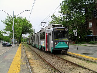
The Green Line is a light rail system run by the Massachusetts Bay Transportation Authority (MBTA) in the Boston, Massachusetts, metropolitan area. It is the oldest Boston subway line, and with tunnel sections dating from 1897, the oldest in America. It runs underground through downtown Boston, and on the surface on several radial boulevards and into inner suburbs. With an average daily weekday ridership of 169,600 in 2018, it is the third most heavily used light rail system in the country. The line was assigned the green color in 1967 during a systemwide rebranding because several branches pass through sections of the Emerald Necklace of Boston.

Harvard is a rapid transit and bus transfer station in Cambridge, Massachusetts. Located at Harvard Square, it serves the MBTA's Red Line subway system as well as MBTA Buses. The third-busiest MBTA subway station, Harvard averaged 23,199 entries each weekday in 2013, with only Downtown Crossing and South Station handling more passengers. It is also an important transfer point, with subway, bus, and trackless trolley (trolleybus) service all connecting at the station. Five of the fifteen key MBTA bus routes, with one extended late-night service, stop at the station.

West Philadelphia, nicknamed West Philly, is a section of Philadelphia, Pennsylvania. Though there is no official definition of its boundaries, it is generally considered to reach from the western shore of the Schuylkill River, to City Avenue to the northwest, Cobbs Creek to the southwest, and the SEPTA Media/Elwyn Line to the south. An alternate definition includes all city land west of the Schuylkill; this would also include Southwest Philadelphia and its neighborhoods. The eastern side of West Philadelphia is also known as University City.
The Middlesex and Boston Street Railway (M&B) was a streetcar and later bus company in the area west of Boston, Massachusetts. Streetcars last ran in 1930, and in 1972 the company's operations were merged into the Massachusetts Bay Transportation Authority (MBTA).

The Boston-area trolleybussystem forms part of the public transportation network serving Greater Boston in the U.S. state of Massachusetts. It opened on April 11, 1936, and since 1964 has been operated by the Massachusetts Bay Transportation Authority (MBTA). It currently includes two physically isolated networks: one serving the towns of Cambridge, Belmont, and Watertown, the other – the Silver Line (Waterfront) – located in the city of Boston proper. Prior to 1964, several additional trolleybus lines were in operation in Boston proper. Measured by fleet size, the system was the third-largest trolleybus system in the United States at its peak, with only the Chicago and Atlanta systems having more trolleybuses than Boston's 463.
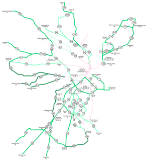
As with many large cities, a large number of Boston-area streetcar lines once existed. However, only a few remain, namely the four branches of the Green Line and the Ashmont-Mattapan High Speed Line, with only one running regular service on an undivided street.
Ashmont is an intermodal transit station in Boston, Massachusetts. Located at Peabody Square in the Dorchester neighborhood, serves the MBTA's Red Line rapid transit line, the Ashmont–Mattapan High Speed Line, and the MBTA Bus system. It is the southern terminus of the Red Line's Dorchester Branch, and the northern terminus of the Ashmont–Mattapan Line. Ashmont station is fully accessible for all modes.
The Phoenix Street Railway provided streetcar service in Phoenix, Arizona, from 1887 to 1948. The motto was, "Ride a Mile and Smile the While."

Streetcars and interurbans operated in the Maryland suburbs of Washington, D.C., between 1890 and 1962. Lines in Maryland were established as separate legal entities, but eventually they were all owned or leased by DC Transit. Unlike the Virginia lines, the Washington and Maryland lines were scheduled as a single system. Most of the streetcars were built with grand plans in mind, but none succeeded financially. A combination of the rise of the automobile, various economic downturns and bustitution eventually spelled the end of streetcars in southern Maryland.

The Third Avenue Railway System (TARS), founded 1852, was a streetcar system serving the New York City boroughs of Manhattan and the Bronx along with lower Westchester County. For a brief period of time, TARS also operated the Steinway Lines in Long Island City.

The Red Line is a line on the Pittsburgh Light Rail system that runs between South Hills Village and Downtown Pittsburgh via the Beechview neighborhood. The companion route, the Blue Line, branches off north of Martin Villa and runs through Overbrook. In March 2007, the closure of the Palm Garden Bridge for refurbishment suspended the Red Line for five months; it resumed service in September.
The Brooklyn and North River Line, operated by the Brooklyn and North River Railroad, was a trolley line in Manhattan and Brooklyn, New York City, United States. Its route ran from the Desbrosses Street Ferry across Lower Manhattan via the Canal Street Crosstown Line, over a pair of tracks on the east side of the Manhattan Bridge, and to the intersection of Flatbush Avenue and Fulton Street in Downtown Brooklyn. Operation in Manhattan and over the bridge was with conduit electrification, while in Brooklyn it used overhead trolley wire, switching at a plow pit.

The B47 is a surface transit line on Ralph Avenue in Brooklyn, New York City, United States. Once a streetcar line, it is now part of the B47 bus route, operated by the New York City Transit Authority, Prior to 1995, it was the B78 route; the northern part of the route from St. Johns Place to Woodhull Hospital was part of the B40 line. The B47 was created as a result of a merge of the B40 and B78 on September 8, 2002.
Riverside is an intown predominantly white and latino suburban neighborhood located on the Upper Westside of Atlanta. It is so named because it is situated along the Chattahoochee River.

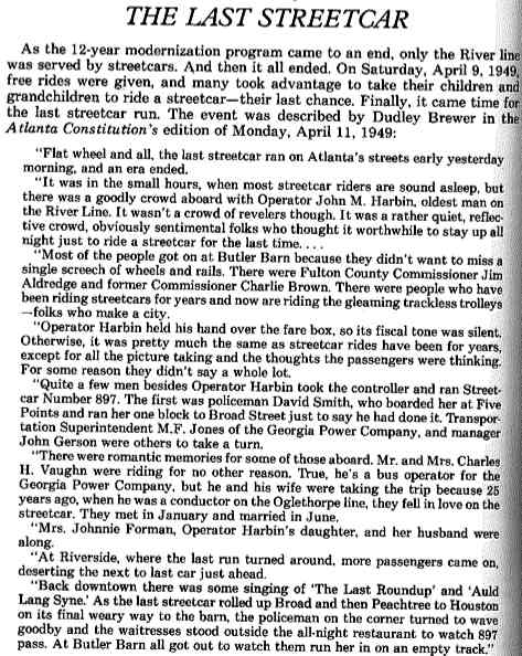
Streetcars originally operated in Atlanta downtown and into the surrounding areas from 1871 until the final line's closure in 1949.
In Atlanta, Georgia, trolleybuses, generally called trackless trolleys there, were a major component of the public transportation system in the middle decades of the 20th century, carrying some 80 percent of all transit riders during the period when the system was at its maximum size. At the end of 1949 Atlanta had a fleet of 453 trolleybuses, the largest in the United States, and it retained this distinction until 1952, when it was surpassed by Chicago.
Marietta Street Artery is an officially defined neighborhood of the city of Atlanta, Georgia, part of the West Midtown area of Atlanta, also known as the "Westside."

The Williamsburg Bridge Plaza, sometimes called Washington Plaza or the Williamsburg Bridge Transit Center, is a major bus terminal and former trolley terminal located at the foot of the Williamsburg Bridge in the New York City borough of Brooklyn, one block west of the Brooklyn-Queens Expressway (I-278). It is situated by the boundaries of Broadway, Havemeyer Street, Roebling Street and South 5th Street, south of the LaGuardia Playground. It contains six bus lanes and serves as a terminal for the many MTA New York City Transit Authority bus routes of Brooklyn and Queens that start and end their runs there.
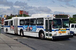
The Bx15 bus route constitutes a public transit line running primarily along Third Avenue and Willis Avenue through the South Bronx in New York City. Crossing into Manhattan, the full route also provides crosstown service along 125th Street in Harlem. Between its northern terminal at Fordham Plaza and The Hub at 149th Street, the route parallels the Bx41 bus route on Webster Avenue; the two routes are sometimes considered to share a single transit corridor through the central portion of the South Bronx.


