River Wensum SSSI

Last updated
River Wensum
Site of Special Scientific Interest

Lenwade9.JPG

The river at Lenwade
Area of Search Norfolk
Grid reference TF942246 to TG250078
Interest Biological
Area 971.9 (ac) 393.3 (ha)
Notification 1993
Location map English Nature

The River Wensum SSSI is a 'whole river' Site of Special Scientific Interest located on the River Wensum that flows through the English county of Norfolk. The river was designated a SSSI in 1993 and a Special Area of Conservation SAC in 2000. It covers 44 miles (71 km) of the Upper Wensum from its source close to South Raynham downstream to Hellesdon Mill an area of 971.9 acres (393.3 ha). [1]

Site of Special Scientific Interest conservation designation denoting a protected area in the United Kingdom

A Site of Special Scientific Interest (SSSI) in Great Britain or an Area of Special Scientific Interest (ASSI) in the Isle of Man and Northern Ireland is a conservation designation denoting a protected area in the United Kingdom and Isle of Man. SSSI/ASSIs are the basic building block of site-based nature conservation legislation and most other legal nature/geological conservation designations in the United Kingdom are based upon them, including national nature reserves, Ramsar sites, Special Protection Areas, and Special Areas of Conservation. The acronym "SSSI" is often pronounced "triple-S I".

River Wensum River in Norfolk, England

The River Wensum is a chalk river in Norfolk, England and a tributary of the River Yare, despite being the larger of the two rivers. The river is a biological Site of Special Scientific Interest and Special Area of Conservation.

England Country in north-west Europe, part of the United Kingdom

England is a country that is part of the United Kingdom. It shares land borders with Wales to the west and Scotland to the north-northwest. The Irish Sea lies west of England and the Celtic Sea lies to the southwest. England is separated from continental Europe by the North Sea to the east and the English Channel to the south. The country covers five-eighths of the island of Great Britain, which lies in the North Atlantic, and includes over 100 smaller islands, such as the Isles of Scilly and the Isle of Wight.

Contents

Description

The Wensum's upper reaches are fed by springs that rise from chalk and was selected as being one of the best examples of a lowland chalk and oolite river type III. There are four species of European importance in the river; the bullhead, the brook lamprey, the white-clawed crayfish and Desmoulin's whorl snail. [1] [2] In addition the river holds 100 plant species including water crowfoot and water starwort [2]

Chalk stream stream that flows through chalk hills towards the sea

Chalk streams are streams that flow through chalk hills towards the sea. They are typically wide and shallow, and due to the filtering effect of the chalk their waters are alkaline and very clear. Chalk streams are popular with fly fishermen who fish for trout on these rivers.

Oolite Sedimentary rock formed from ooids

Oolite or oölite is a sedimentary rock formed from ooids, spherical grains composed of concentric layers. The name derives from the Ancient Greek word ᾠόν for egg. Strictly, oolites consist of ooids of 0.25–2 millimetres' diameter; rocks composed of ooids larger than 2 mm are called pisolites. The term oolith can refer to oolite or individual ooids.

Europe Continent in the Northern Hemisphere and mostly in the Eastern Hemisphere

Europe is a continent located entirely in the Northern Hemisphere and mostly in the Eastern Hemisphere. It is bordered by the Arctic Ocean to the north, the Atlantic Ocean to the west and the Mediterranean Sea to the south. It comprises the westernmost part of Eurasia.

Conservation

After many years of decline a survey was commissioned by Natural England in 2002. It showed that the ecological condition of the river had declined. The principal reasons for this were water quality and siltation. Water quality has been addressed and was improving, but the physical character of the river needs to be restored. In 2008, a partnership known as the River Wensum Restoration Strategy (RWRS) was formed between; Environment Agency; Water Management Alliance and Natural England [3] to restore the physical functioning of the Wensum. The 2002 report found that fourteen redundant water mills along the Wensum as having the most significant factor affecting morphology of the river channel, with 67% of the river backed up behind these structures. As a priority, the strategy recommended the lowering, removal or bypassing of these structures to allow more of the river to function naturally. [4] Since 2008, the (RWRS) has made several improvements to the river. The holistic whole river approach with co-operation from land owners, fisheries managers and other organizations has seen ongoing projects ranging from restoring gravel glides to removing silt. [3]

Natural England is a non-departmental public body in the United Kingdom sponsored by the Department for Environment, Food and Rural Affairs. It is responsible for ensuring that England's natural environment, including its land, flora and fauna, freshwater and marine environments, geology and soils, are protected and improved. It also has a responsibility to help people enjoy, understand and access the natural environment.

Water quality chemical, physical, biological, and radiological characteristics of water

Water quality refers to the chemical, physical, biological, and radiological characteristics of water. It is a measure of the condition of water relative to the requirements of one or more biotic species and or to any human need or purpose. It is most frequently used by reference to a set of standards against which compliance, generally achieved through treatment of the water, can be assessed. The most common standards used to assess water quality relate to health of ecosystems, safety of human contact, and drinking water.

Siltation or siltification is the pollution of water by particulate terrestrial clastic material, with a particle size dominated by silt or clay. It refers both to the increased concentration of suspended sediments, and to the increased accumulation of fine sediments on bottoms where they are undesirable. Siltation is most often caused by soil erosion or sediment spill.

The Norfolk Anglers Conservation Association (NACA) carried out a successful river habitat restoration at their Sayers Meadow fishery at Lyng in the early 1980s. [5] After dredging and a major abstraction pipeline had a detrimental effect on the Costessey Point fishery, the association has taken action to restore this well known water. The ongoing work will be used as a blueprint for future river conservation projects. [6]

Lyng, Norfolk village and civil parish in the English county of Norfolk

Lyng is a village and civil parish in the English county of Norfolk. It is situated on the River Wensum, some 10 km (6.2 mi) north-east of the town of East Dereham and 20 km (12 mi) north-west of the city of Norwich.

Abstraction in its main sense is a conceptual process where general rules and concepts are derived from the usage and classification of specific examples, literal signifiers, first principles, or other methods.

Costessey village in the United Kingdom

Costessey is a civil parish situated 4 miles (6.4 km) west of Norwich in Norfolk, England. The parish comprises two settlements: the long-established village of Costessey, and New Costessey, which developed during the first half of the 20th century and has become a suburb of Norwich. The two settlements are separated by the River Tud and by arable land. Costessey's northern boundary with Taverham, Drayton and Hellesdon follows the course of the River Wensum.

Related Research Articles

Halvergate Marshes area of grazing marsh in the east of the English county of Norfolk

The Halvergate Marshes are an area of grazing marsh in the east of the English county of Norfolk. They form part of the area of The Broads and lie between the River Bure and the River Yare, bordering Breydon Water on the east. The marshes cover an area of around 2,642 hectares An area of 1,432.7-hectare (3,540-acre) is a biological Site of Special Scientific Interest. Some areas are also in the Breydon Water Local Nature Reserve, the Broadland and Breydon Water Ramsar sites, The Broads Special Area of Conservation, and The Broads and Breydon Water Special Protection Areas.

Marriotts Way long-distance foot, cycle path and bridleway between Norwich and Aylsham

The Marriott's Way is a long-distance footpath, cycle-path and bridleway between Norwich and Aylsham, Norfolk, England. It forms part of the National Cycle Network (NCN) and the red route of Norwich's Pedalways cycle path network. It is open to walkers, cyclists and horse riders. Its total length is 24.6 miles (39.5 km). It has a mixture of surfaces; tarmac, compacted gravel, and earth. The name of the route originates from the chief engineer and manager of the Midland and Great Northern Joint Railway (M&GNJR), William Marriott, who held the position for 41 years.

River Blythe river in the English Midlands

The River Blythe flows through the English Midlands from Southern Warwickshire, through the borough of Solihull and on to Coleshill. It runs along the Meriden Gap in the Midlands Plateau, is fed by the River Cole and is a tributary of the River Tame beside the West Midland Bird Club's Ladywalk reserve. This then joins the River Trent, whose waters reach the North Sea via the Humber Estuary.

Gloucestershire Wildlife Trust organization

The Gloucestershire Wildlife Trust is the Gloucestershire local partner in a conservation network of 47 Wildlife Trusts. The Wildlife Trusts are local charities with the specific aim of protecting the United Kingdom's natural heritage. The Gloucestershire Wildlife Trust is managed by a Board of Trustees elected from its membership who provide overall direction for the development of the Trust and there are Advisory Committees. The work of the trust is carried out through staff and volunteers.

Coombe Hill Canal

Coombe Hill Canal lies in the Vale of Gloucester, south west England, north of Leigh and runs west 2.75 miles (4.43 km) from Coombe Hill Basin to the River Severn near Wainlode Hill. It opened in 1796 and closed 80 years later in 1876, after the only lock was damaged by flooding. The Gloucestershire Wildlife Trust purchased the Coombe Hill Canal nature reserve in 1985 and the area is managed by the trust. Adjacent to the Coombe Hill Canal is a large area of wet meadowland situated midway between Gloucester and Tewkesbury to the west of the A38, which was purchased by the trust in 1999. There is a north and a south meadow. This land and the Canal itself often flood in winter, which attracts hundreds of wildfowl.

Dee Estuary river estuary marking the border of north Wales and England

The Dee Estuary is a large estuary by means of which the River Dee flows into Liverpool Bay. The estuary starts near Shotton after a five-mile (8 km) 'canalised' section and the river soon swells to be several miles wide forming the boundary between the Wirral Peninsula in north-west England and Flintshire in north-east Wales.

River Tud river in Norfolk, United Kingdom

River Tud is a tributary of the River Wensum, Norfolk in the East of England. The Tud's source is just south of East Dereham and it flows in an easterly direction for 27 kilometres (17 mi) to its confluence with the Wensum below Hellesdon mill.

Frank Sawyer MBE (1906–1980) was an English Riverkeeper, writer, and inventor of such flies as the Pheasant Tail Nymph. Sawyer also invented a number of different animal traps some of which bore his name, and the most widely used is still approved for use in the UK although no longer in production. He died in 1980 on the banks of the River Avon at Netheravon.

Sweetbriar Road Meadows, Norwich

Sweetbriar Road Meadows, Norwich is a 9.7-hectare (24-acre) biological Site of Special Scientific Interest in Norwich in Norfolk.

Wensum Local Nature Reserve

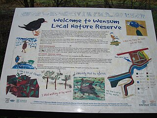
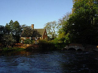
Wensum Local Nature Reserve or Wensum Valley is a Local Nature Reserve located in Norwich in the English county of Norfolk. The reserve consists of two sites; Mile Cross Marsh52.6419°N 1.2657°E and Sycamore Crescent Wood which are linked by the Riverside Path a public footpath via the Sycamore Crescent footbridge

Barnby Broad and Marshes human settlement in United Kingdom

Barnby Broad and Marshes is a Site of Special Scientific Interest (SSSI) in the Waveney district of the English county of Suffolk. The site is 189.6 hectares in size. It is in the parishes of North Cove and Barnby, located between Beccles and Lowestoft in the north of the county. The site is bordered on its southern edge by the East Suffolk railway line and to the north by the River Waveney. It is a Special Area of Conservation, a Special Protection Area under the EC Birds Directive, and a Ramsar internationally important wetland site. There are two Suffolk Wildlife Trust nature reserves in the site, Castle Marshes and North Cove.

Blo Norton and Thelnetham Fens Suffolk Wildlife Trust nature reserve

Blo' Norton and Thelnetham Fens are a 21.3 hectare biological Site of Special Scientific Interest (SSSI) on the Norfolk/Suffolk border. Blo' Norton Fen is in the parish of Blo' Norton in Norfolk and Thelnetham Fen is in Thelnetham parish in Suffolk. It is a Nature Conservation Review site, Grade 2, and part of the Waveney and Little Ouse Valley Fens Special Area of Conservation, Thelnetham Fen is managed by the Suffolk Wildlife Trust and Blo' Norton Fen by the Little Ouse Headwaters Project (LOHP).

Salmonsbury Meadows SSSI

Salmonsbury Meadows is an 18-hectare (44-acre) biological and geological Site of Special Scientific Interest in Gloucestershire, notified in 1985. The site is listed in the 'Cotswold District' Local Plan 2001-2011 as a Key Wildlife Site (KWS).

Old River Severn, Upper Lode

Old River Severn, Upper Lode is a 3.72-hectare (9.2-acre) biological Site of Special Scientific Interest in Gloucestershire, notified in 1985. It is a cross county border site between Gloucestershire and Herefordshire and Worcestershire.

Dereham Rush Meadow biological Site of Special Scientific Interest north-west of Dereham in Norfolk

Dereham Rush Meadow is a 22.2-hectare (55-acre) biological Site of Special Scientific Interest north-west of Dereham in Norfolk.

References

  1. 1 2 English Nature Retrieved 26 April 2011
  2. 1 2 Wensum Valley Trust Retrieved 5 May 2011
  3. 1 2 Environment Agency- River Wensum Restoration Strategy Retrieved 30 March 2011
  4. Natural England Retrieved 3 May 2011
  5. Sayers Meadow Retrieved 3 May 2011
  6. Costessey Point Retrieved 15 April 2011

Coordinates: 52°46′45″N0°49′52″E / 52.7791°N 0.8310°E / 52.7791; 0.8310

Geographic coordinate system Coordinate system

A geographic coordinate system is a coordinate system that enables every location on Earth to be specified by a set of numbers, letters or symbols. The coordinates are often chosen such that one of the numbers represents a vertical position and two or three of the numbers represent a horizontal position; alternatively, a geographic position may be expressed in a combined three-dimensional Cartesian vector. A common choice of coordinates is latitude, longitude and elevation. To specify a location on a plane requires a map projection.