Roaches Grit

Last updated

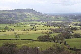
Roaches Grit is a coarse sandstone which outcrops widely throughout the western part of the Peak District of northern England and gives rise to several significant landscape features in the area. Its counterpart in the eastern part of the National Park is the Ashover Grit.

Gritstone A hard, coarse-grained, siliceous sandstone

Gritstone or grit is a hard, coarse-grained, siliceous sandstone. This term is especially applied to such sandstones that are quarried for building material. British gritstone was used for millstones to mill flour, to grind wood into pulp for paper and for grindstones to sharpen blades. "Grit" is often applied to sandstones composed of angular sand grains. It may commonly contain small pebbles.

Peak District Upland area in England

The Peak District is an upland area in England at the southern end of the Pennines. It is mostly in northern Derbyshire, but also includes parts of Cheshire, Greater Manchester, Staffordshire, West Yorkshire and South Yorkshire. An area of great diversity, it is split into the Dark Peak, where most of the moorland is found and the geology is gritstone, and the limestone area of the White Peak.

England Country in north-west Europe, part of the United Kingdom

England is a country that is part of the United Kingdom. It shares land borders with Wales to the west and Scotland to the north-northwest. The Irish Sea lies west of England and the Celtic Sea lies to the southwest. England is separated from continental Europe by the North Sea to the east and the English Channel to the south. The country covers five-eighths of the island of Great Britain, which lies in the North Atlantic, and includes over 100 smaller islands, such as the Isles of Scilly and the Isle of Wight.

The combined Roaches Grit and Ashover Grit are amongst the most widespread sandstone units within the Millstone Grit Group of the Peak District. Along with other similar sandstones, such as the immediately overlying Chatsworth Grit, it is assigned to the Marsdenian sub-stage of the Namurian stage within the Carboniferous period.

Millstone Grit

Millstone Grit is the name given to any of a number of coarse-grained sandstones of Carboniferous age which occur in the British Isles. The name derives from its use in earlier times as a source of millstones for use principally in watermills. Geologists refer to the whole suite of rocks that encompass the individual limestone beds and the intervening mudstones as the Millstone Grit Group. The term Millstone Grit Series was formerly used to refer to the rocks now included within the Millstone Grit Group together with the underlying Edale Shale Group.

In chronostratigraphy, a stage is a succession of rock strata laid down in a single age on the geologic timescale, which usually represents millions of years of deposition. A given stage of rock and the corresponding age of time will by convention have the same name, and the same boundaries.

The Namurian is a stage in the regional stratigraphy of northwest Europe with an age between roughly 326 and 313 Ma. It is a subdivision of the Carboniferous system or period and the regional Silesian series. The Namurian is named for the Belgian city and province of Namur where strata of this age occur. The Millstone Grit Group in the lithostratigraphy of northern England and parts of Wales is also of Namurian age.

The two units which, prior to the doming and erosion of the central Peak District were once one, are interpreted as delta-top sandstones. The deposited material was brought down from a northerly source by braided rivers.

Landscape features

Amongst the features for which the Roaches Grit is responsible are Axe Edge, The Roaches, Hen Cloud, Ramshaw Rocks, Back Forest and Hangingstone. The natural chasm of Lud’s Church is developed within the Roaches Grit whilst it also forms the lower slopes of Shutlingsloe.

The Roaches mountain in United Kingdom

The Roaches is a prominent rocky ridge above Leek and Tittesworth Reservoir in the Peak District of England. The ridge with its rock formations rises steeply to 505 m (1,657 ft).

Luds Church deep chasm on the hillside above Gradbach, Staffordshire, England

Lud's Church is a deep chasm penetrating the Millstone Grit bedrock created by a massive landslip on the hillside above Gradbach, Staffordshire, England. It is located in a wood known as Back Forest, in the Dark Peak, towards the southwest fringe of the Peak District National Park about 4 kilometres (2.5 mi) west of the A53 between Leek and Buxton. Over 100 metres (328 ft) long and 18 metres (59 ft) deep, all but the upper third of the slope has slipped forward towards the River Dane. It is mossy and overgrown, wet and cool even on the hottest of days.

Shutlingsloe mountain in United Kingdom

Shutlingsloe is a hill near the village of Wildboarclough, in the east of the county of Cheshire. It stands to the south of Macclesfield Forest, on the edge of the Peak District and within the Peak District National Park.

Equally the Ashover Grit contributes to the landscape in the form of Stanton Moor and Harthill Moor. The former is home to gritstone quarries whilst the latter boasts Robin Hood’s Stride and Cratcliffe Tor. Much of the country around Edensor and Baslow (though not Baslow Edge) and around Ashover, from whence it derives its name, is underlain and shaped by this rock.

Stanton Moor

Stanton Moor is a small upland area in the Derbyshire Peak District of central and northern England, lying between Matlock and Bakewell near the villages of Birchover and Stanton-in-Peak. It is known for its megaliths – particularly the Nine Ladies stone circle – and for its natural, wind-eroded sandstone pillars.

Robin Hoods Stride

Robin Hood's Stride is a rock formation on the Limestone Way in Derbyshire close to the village of Elton. The nearest town is Bakewell, to the north. The popular tourist spot can be accessed via the Limestone Way just off the B5056 between Haddon Hall and Winster, or from the unclassified road from Alport to Elton using either the Limestone Way, a concessionary footpath or Access Land. Both options have limited parking at the side of the road.

Edensor village and civil parish in Derbyshire Dales district, Derbyshire, England

Edensor is a village and civil parish in Derbyshire, England. The population of the civil parish as of the 2011 census was 145. It is the closest village to Chatsworth House. Much of it belongs to the Dukes of Devonshire, most of whom are buried in the churchyard of St Peter's Church.

Related Research Articles

Rock climbing is a popular activity in the Peak District; particularly on edges such as Stanage or Froggatt. Generally the climbing style is free climbing and the rock is either gritstone or limestone. Climbing has been practised in the Peak District since the late 19th century; James W. Puttrell is generally credited with starting the sport. The first climbing guidebook to the area was Some Gritstone Climbs, by John Laycock, published in 1913. There are over 10,000 routes in the Peak District. One of the most famous Peak District climbers, and a pioneer of many new routes, is Ron Fawcett. The climb known as "Master's Edge", on Millstone Edge, near Hathersage, is a testament to his skill and strength. The climb is graded E7 6c and rises 19m up the near vertical edge.

Pennines mountain range

The Pennines, also known as the Pennine Chain or Pennine Hills, are a range of mountains and hills in England separating North West England from Yorkshire and North East England.

Dark Peak

The Dark Peak is the higher and wilder part of the Peak District in England, mostly forming the northern Peak District but also extends south into its eastern and western margins. It is mainly in Derbyshire and parts of Staffordshire, Cheshire, Greater Manchester, West Yorkshire and South Yorkshire.

Stanage Edge mountain in the United Kingdom

Stanage Edge, or simply Stanage is a gritstone escarpment in the Peak District, England, famous as a location for climbing. The northern part of the edge forms the border between the High Peak of Derbyshire and Sheffield in South Yorkshire. Its highest point is High Neb at 458 metres (1,503 ft) above sea level. Areas of Stanage were quarried in the past to produce grindstones, and some can still be seen on the hillside—carved, but never removed.

Geology of Great Britain

The geology of Great Britain is renowned for its diversity. As a result of its eventful geological history, Great Britain shows a rich variety of landscapes across the constituent countries of England, Wales and Scotland. Rocks of almost all geological ages are represented at outcrop, from the Archaean onwards.

The Rough Rock is a widespread unit of coarse sandstone which is a prominent landscape-forming feature in the Peak District and Pennines of northern England. It is assigned by geologists to the Yeadonian sub-stage of the Namurian stage of the Carboniferous period.

Froggatt Edge

Froggatt Edge is a gritstone escarpment in the Dark Peak area of the Peak District National Park, in Derbyshire, England, close to the villages of Froggatt, Calver, Curbar, Baslow and Grindleford. The name Froggatt Edge applies only to the northernmost section of the escarpment; the middle and southernmost sections are called Curbar Edge and Baslow Edge respectively. The escarpment, like many in this area, is easily accessible from Sheffield.

Derwent Edge mountain in United Kingdom

Derwent Edge is a Millstone Grit escarpment that lies above the Upper Derwent Valley in the Peak District National Park in the English county of Derbyshire. An Ordnance Survey column marks the highest point of the Edge at Back Tor. North of Back Tor the edge extends into Howden Edge and enters the county of South Yorkshire.

The geology of Cheshire in England consists mainly of Triassic sandstones and mudstones. To the north west of Cheshire, these rocks are heavily faulted and the underlying Carboniferous Coal Measures are thrown up. Around the areas of Poynton and Macclesfield, the coal is close to the surface and was easily mined. Below the Coal Measures is the Millstone Grit, which appears towards the Derbyshire border on the flanks of the Peak District dome.

Geology of England

The geology of England is mainly sedimentary. The youngest rocks are in the south east around London, progressing in age in a north westerly direction. The Tees-Exe line marks the division between younger, softer and low-lying rocks in the south east and the generally older and harder rocks of the north and west which give rise to higher relief in those regions. The geology of England is recognisable in the landscape of its counties, the building materials of its towns and its regional extractive industries.

The geology of Wales is complex and varied; its study has been of considerable historical significance in the development of geology as a science. All geological periods from the Cryogenian to the Jurassic are represented at outcrops, whilst younger sedimentary rocks occur beneath the seas immediately off the Welsh coast. The effects of two mountain-building episodes have left their mark in the faulting and folding of much of the Palaeozoic rock sequence. Superficial deposits and landforms created during the present Quaternary period by water and ice are also plentiful and contribute to a remarkably diverse landscape of mountains, hills and coastal plains.

The Cloud (Peak District) prominent hill in England

The Cloud or Bosley Cloud is a prominent hill on the border between Cheshire and Staffordshire a couple of miles west of the Peak District National Park boundary.

Geology of Yorkshire

The Geology of Yorkshire in northern England shows a very close relationship between the major topographical areas and the geological period in which their rocks were formed. The rocks of the Pennine chain of hills in the west are of Carboniferous origin whilst those of the central vale are Permo-Triassic. The North York Moors in the north-east of the county are Jurassic in age while the Yorkshire Wolds to the south east are Cretaceous chalk uplands. The plain of Holderness and the Humberhead levels both owe their present form to the Quaternary ice ages. The strata become gradually younger from west to east.

Marros Group

The Marros Group is the name given to a suite of rocks of Namurian age laid down during the Carboniferous Period in South Wales. These rocks were formerly known as the Millstone Grit Series but are now distinguished from the similar but geographically separate rock sequences of the Pennines and Peak District of northern England and northeast Wales by this new name.

The geology of Lancashire in northwest England consists in the main of Carboniferous age rocks but with Triassic sandstones and mudstones at or near the surface of the lowlands bordering the Irish Sea though these are largely obscured by Quaternary deposits.

The geology of Merseyside in northwest England largely consists of a faulted sequence of Carboniferous Coal Measures rocks overlain in the west by younger Triassic and Permian age sandstones and mudstones. Glaciation during the present Quaternary Period has left widespread glacial till as well as erosional landforms. Other post-glacial superficial deposits such as river and estuarine alluvium, peat and blown sand are abundant.

References