Shutlingsloe

Last updated

Shutlingsloe
Shutlingsloe.jpg
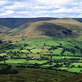
Shutlingsloe from Macclesfield Forest path
Highest point
Elevation 506 m (1,660 ft)
Prominence c. 134 m
Listing none
Geography
Location Cheshire, Flag of England.svg  England
Parent range Peak District
OS grid SJ976695
Topo map OS Outdoor Leisure 24

Shutlingsloe is a hill near the village of Wildboarclough, in the east of the county of Cheshire. It stands to the south of Macclesfield Forest, on the edge of the Peak District and within the Peak District National Park. [1]

Contents

A steep-sided hill with a distinctive profile, [1] sometimes described as the 'Matterhorn of Cheshire', it is the third highest peak in the historic county (Black Hill being the highest and Shining Tor second highest) with an elevation of 506 m (1,660 ft) and commands excellent views over Cheshire. The Peak District Boundary Walk crosses the summit, which is the highest point on the footpath's 200-mile long route. [2]

The name derives from old English 'Scyttel's hlaw' meaning 'Scyttel's (personal name) hill' and is one of several 'low' names in the Peak District, from the same Old English root that gives rise to the name "Law" for many hills in southern Scotland. [3]

Geology

The hill is formed from alternating layers of mudstones and coarse sandstones (referred to as 'gritstones' or simply 'grits') which were laid down in a delta system in the Carboniferous period. The summit tor is formed from the Chatsworth Grit and the lower slopes from the Roaches Grit. Several geological faults run northwest to southeast through the hill. [4]

Related Research Articles

Dark Peak

The Dark Peak is the higher and wilder part of the Peak District in England, mostly forming the northern section but also extending south into its eastern and western margins. It is mainly in Derbyshire but parts are in Staffordshire, Cheshire, Greater Manchester, West Yorkshire and South Yorkshire.

Ingleborough

Ingleborough is the second-highest mountain in the Yorkshire Dales, England. It is one of the Yorkshire Three Peaks, and is frequently climbed as part of the Three Peaks walk. A large part of Ingleborough is designated as a Site of Special Scientific Interest and National Nature Reserve and is the home of a new joint project, Wild Ingleborough, with aims to improve the landscape for wildlife and people.

Great Whernside

Great Whernside is a fell in the Yorkshire Dales, England, not to be confused with Whernside, some 17 miles (27 km) to the west. Its summit is the highest point of the eastern flank of Wharfedale above Kettlewell. Great Whernside forms the watershed between Wharfedale and Nidderdale, and is on the boundary between the Yorkshire Dales National Park and Nidderdale Area of Outstanding Natural Beauty. The River Nidd rises on the eastern slopes of Great Whernside, above Angram Reservoir.

Shining Tor

Shining Tor is the highest hill in the modern ceremonial county of Cheshire, England. The summit has a maximum elevation of 559 m (1,834 ft) above sea level. It is in the Peak District, between the towns of Buxton and Macclesfield, and is on the administrative boundary between Derbyshire and Cheshire East. The hill is at the south end of a north-south moorland ridge, which also includes Cats Tor, 519 metres (1,703 ft) high.

Urra Moor

Urra Moor is the highest moor in the North York Moors, North Yorkshire, England. At 1,490 feet (454 m) above sea level it is the highest point in Hambleton District and the North York Moors National Park, and the fourteenth most prominent hill in England. The name is a mix of Old English and Old Norse which means The Dirty Hill. The name of Urra Moor applies to the moor as a whole; the summit itself is known as Round Hill.

Crook Hill

Crook Hill is a small hill in the Peak District National Park in the English county of Derbyshire, 5 kilometres (3.1 mi) northeast of Castleton.

Derwent Edge Escarpment in United Kingdom

Derwent Edge is a Millstone Grit escarpment that lies above the Upper Derwent Valley in the Peak District National Park in the English county of Derbyshire. An Ordnance Survey column marks the highest point of the Edge at Back Tor. North of Back Tor the edge extends into Howden Edge and enters the county of South Yorkshire.

Wild Boar Fell

Wild Boar Fell is a mountain in the Yorkshire Dales National Park, on the eastern edge of Cumbria, England. At 2,323 feet (708 m), it is either the 4th-highest fell in the Yorkshire Dales or the 5th, depending on whether nearby High Seat (2,326 ft) is counted or not.

Wildboarclough Human settlement in England

Wildboarclough is a village in east Cheshire, England, in the civil parish of Macclesfield Forest and Wildboarclough within the Peak District National Park. Bilsborough states that the name arises from the rapid rise in levels of the Clough Brook after a heavy fall of rain, but Mills gives it as a deep valley frequented by wild boar. According to old legend it was the place where the last wild boar in England was killed.

Stanton Moor

Stanton Moor is a small upland area in the Derbyshire Peak District of central and northern England, lying between Matlock and Bakewell near the villages of Birchover and Stanton-in-Peak. It is known for its megaliths – particularly the Nine Ladies stone circle – and for its natural, wind-eroded sandstone pillars. The Peak District Boundary Walk runs across the moor.

Eldon Hill Hill in United Kingdom

Eldon Hill is a hill in the Peak District National Park in the county of Derbyshire, England, 4 kilometres (2.5 mi) southwest of the village of Castleton. It is a 470-metre (1,540 ft) limestone hill whose pastureland is used for rough grazing, although a large proportion has been lost to limestone quarrying. It lies within the Castleton Site of Special Scientific Interest. Eldon Hill was formed when a bed of pure limestone was squeezed and upfolded by geological forces to form a dome; it is the highest limestone hill north of the River Wye.

Boulsworth Hill

Boulsworth Hill is a large expanse of moorland, the highest point of the South Pennines of south-eastern Lancashire, England, separating the Borough of Pendle from Calderdale.

The Cloud (Peak District)

The Cloud or Bosley Cloud is a prominent hill on the border between Cheshire and Staffordshire a couple of miles west of the Peak District National Park boundary.

Mountains and hills of England

The mountains and hills of England comprise very different kinds of terrain, from a mountain range which reaches almost 1,000 metres high, to several smaller areas of lower mountains, foothills and sea cliffs. Most of the major upland areas have been designated as Areas of Outstanding Natural Beauty (AONB) or national parks. The highest and most extensive areas are in the north and west, while the midlands, south-east and east of the country tend to be low-lying.

Teggs Nose Hill and country park in Cheshire, England

Tegg's Nose is a hill east of Macclesfield in Cheshire, England. It has a short ridge with a high point of 380 metres (1246 feet) at SJ947725, terminating in a promontory at the southern end. It lies on the western edge of the Peak District, although outside the boundary of the national park. Much of the hill's area falls within the Tegg's Nose Country Park, managed by Cheshire East Council Countryside Management Service; Tegg's Nose is also part of the Environmentally Sensitive Area Scheme.

Macclesfield Forest

Macclesfield Forest is an area of woodland, predominantly conifer plantation, located around 3 mi (5 km) south east of Macclesfield in the civil parish of Macclesfield Forest and Wildboarclough, in Cheshire, England. The existing woodland is the last substantial remnant of the Royal Forest of Macclesfield, a once-extensive ancient hunting reserve. The area also includes two reservoirs, Trentabank and Ridgegate. Macclesfield Forest lies on the western edge of the Peak District, within the South West Peak, and is partly inside the boundary of the National Park. The hills of Tegg's Nose and Shutlingsloe stand to the north west and south east, respectively; the moorland of High Moor lies to the south and the Goyt Valley lies to the west. Nearby villages include Langley and Wildboarclough.

Roaches Grit is a coarse sandstone which outcrops widely throughout the western part of the Peak District of northern England and gives rise to several significant landscape features in the area. Its counterpart in the eastern part of the National Park is the Ashover Grit.

Bosley Minn

Bosley Minn is one of two names – the other being Wincle Minn – given to a prominent hill in southeast Cheshire and in the southwestern corner of the Peak District National Park in northern England. The long axis of the Minn runs NNE–SSW and its broad summit, which reaches to 386 metres (1,266 ft) at its highest point, slopes away to the valley of the Shell Brook in the east and towards Bosley Reservoir in the west. It is the western aspect of the hill, facing Bosley which is known as Bosley Minn whilst the eastern side which faces the village of Wincle is referred to as Wincle Minn.

Peak District Boundary Walk Long distance footpath in England

The Peak District Boundary Walk is a circular 190-mile (310 km) walking trail, starting and finishing at Buxton and broadly following the boundary of the Peak District, Britain's first national park. The route was developed by the Friends of the Peak District and was launched on 17 June 2017.

The geology of the Peak District National Park in England is dominated by a thick succession of faulted and folded sedimentary rocks of Carboniferous age. The Peak District is often divided into a southerly White Peak where Carboniferous Limestone outcrops and a northerly Dark Peak where the overlying succession of sandstones and mudstones dominate the landscape. The scarp and dip slope landscape which characterises the Dark Peak also extends along the eastern and western margins of the park. Although older rocks are present at depth, the oldest rocks which are to be found at the surface in the national park are dolomitic limestones of the Woo Dale Limestone Formation seen where Woo Dale enters Wye Dale east of Buxton.

References

  1. 1 2 Cheshire County Council: Landscape Character Type 20: Moorland Plateau (2007) (accessed 19 April 2010)
  2. McCloy, Andrew (2017). Peak District Boundary Walk: 190 Miles Around the Edge of the National Park. Friends of the Peak District. ISBN   978-1909461536.
  3. Mcmeeken, L. 'Peak Place-names', Halsgrove 2003
  4. British Geological Survey 1:50,000 map sheet 111 'Buxton' and associated memoir

Commons-logo.svg Media related to Shutlingsloe at Wikimedia Commons

Coordinates: 53°13′24″N2°02′12″W / 53.22321°N 2.03673°W / 53.22321; -2.03673