
Edale is a village and civil parish in the Peak District, Derbyshire, England, whose population was 353 at the 2011 Census. Edale, with an area of 7,030 acres (2,840 ha), is in the Borough of High Peak.

The White Peak, also known as the Low Peak, is a limestone plateau that forms the central and southern part of the Peak District in England. It is mostly between 270 metres (900 ft) and 430 metres (1,400 ft) above sea-level and is enclosed by the higher altitude Dark Peak to the west, north and east.

The Dark Peak is the higher and wilder part of the Peak District in England, mostly forming the northern section but also extending south into its eastern and western margins. It is mainly in Derbyshire but parts are in Staffordshire, Cheshire, Greater Manchester, West Yorkshire and South Yorkshire.

Kinder Scout is a moorland plateau and national nature reserve in the Dark Peak of the Derbyshire Peak District in England. Part of the moor, at 636 metres (2,087 ft) above sea level, is the highest point in the Peak District, the highest point in Derbyshire, and the highest point in the East Midlands. This summit is sometimes simply called the Peak. In excellent weather conditions the city of Manchester and the Greater Manchester conurbation can be seen, as well as Winter Hill near Bolton, and the mountains of Snowdonia in North Wales.
The mountains of Whernside, Ingleborough and Pen-y-ghent are collectively known as the Three Peaks. The peaks, which form part of the Pennine range, encircle the head of the valley of the River Ribble in the Yorkshire Dales National Park in the North of England.

The River Lathkill is a river in the Peak District National Park in Derbyshire, England.

Bonsall is a village and civil parish in the Derbyshire Dales on the edge of the Peak District. The civil parish population, including Brightgate and Horse Dale, was 775 at the 2001 Census, increasing to 803 at the 2011 Census.

Radnor Forest in the county of Radnorshire, Wales is a rock dome composed of Silurian shales, mudstones and limestone in Mid Wales. It is a forest in the medieval sense of the word. It lies within the Welsh Marches region since Offa's Dyke lies nearby to the east.
A reef knoll is a land-based landform that comprises an immense pile of calcareous material that accumulated on a previously existing ancient sea floor. At the time of its accumulation it may have had enough structure from organisms such as sponges to have been free-standing and to withstand the sea currents as material accumulated, and was likely an atoll. Another possibility is the remains of deep water coral. Such structures are thus often fossil-rich.

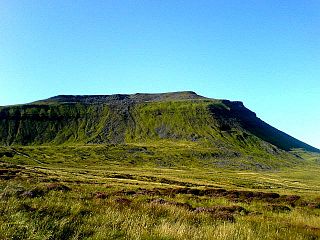
Chrome Hill is a limestone reef knoll in Derbyshire, England, in the upper Dove valley beside the border with Staffordshire, within the civil parish of Hartington Middle Quarter. It is adjacent to Parkhouse Hill, another reef knoll. The walk over Chrome Hill and Parkhouse Hill is known as the Dragon's Back ridge.

Derwent Edge is a Millstone Grit escarpment that lies above the Upper Derwent Valley in the Peak District National Park in the English county of Derbyshire. An Ordnance Survey column marks the highest point of the Edge at Back Tor. North of Back Tor the edge extends into Howden Edge and enters the county of South Yorkshire.

Padley Gorge is a deep but narrow valley in the Peak District, Derbyshire between the village of Grindleford and the A6187 road.

Shutlingsloe is a hill near the village of Wildboarclough, in the east of the county of Cheshire. It stands to the south of Macclesfield Forest, on the edge of the Peak District and within the Peak District National Park.

Eldon Hill is a hill in the Peak District National Park in the county of Derbyshire, England, 4 kilometres (2.5 mi) southwest of the village of Castleton. It is a 470-metre (1,540 ft) limestone hill whose pastureland is used for rough grazing, although a large proportion has been lost to limestone quarrying. It lies within the Castleton Site of Special Scientific Interest. Eldon Hill was formed when a bed of pure limestone was squeezed and upfolded by geological forces to form a dome; it is the highest limestone hill north of the River Wye.
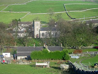
Earl Sterndale is a village in the Upper Dove Valley in the Peak District, Derbyshire, England, situated near the River Dove, 5 miles south of Buxton, and 8 miles west of Bakewell. The population at the 2011 Census is listed under Hartington Middle Quarter. It sits 1,100 feet (340 m) above sea level. The farms surrounding the village were medieval monastic granges in the care of the monks of Basingwerk Abbey. The village church, dedicated to St Michael, was built in 1828 on the site of an ancient chapel. It was substantially destroyed in 1941, when it was bombed by the Germans. It was restored in 1952, and still contains a Saxon font.

High Wheeldon is a distinctive dome-shaped hill near the Staffordshire border in Hartington Middle Quarter civil parish, Derbyshire, in the Peak District valley of Upper Dovedale, overlooking the villages of Earl Sterndale, Longnor and Crowdecote. It is close to the more distinctive and more widely known Chrome Hill and Parkhouse Hill. Popular with walkers, and possessing excellent views of the Dove and Manifold valleys, High Wheeldon is in the care of the National Trust, and has been since 1946 when it was presented by Mr F.A. Holmes of Buxton to the Trust as a war memorial. A plaque at the summit commemorates the presentation, stating that the hill was presented 'in honoured memory of the men of Derbyshire and Staffordshire who fell in the Second World War'.

The Wye Valley is the limestone valley of the River Wye in the White Peak of Derbyshire, England. The source of the River Wye is west of Buxton on Axe Edge Moor. One main channel runs underground through Poole's Cavern. The river flows though Buxton Pavilion Gardens and then along a culvert under the town centre. After leaving the flat area of central Buxton, the Wye Valley becomes distinct as a gorge running east for 10 miles (16 km) before the valley broadens at Ashford-in-the Water.

Burbage Edge is a gritstone escarpment overlooking the Burbage district of Buxton in Derbyshire, in the Peak District. The hill's summit is 500 metres (1,600 ft) above sea level.

Totley Moor is an open moorland hill to the west of the Sheffield suburb of Totley, in the Derbyshire Peak District. The summit is 395 metres (1,296 ft) above sea level.

